The Lost Breyfogle Gold Mine

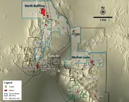
However they are not the only Company doing exploration around that area as you can see below.

4 mines as 2017.JPG

As of 2017.

Kanacki
 

Kanacki

can you merge #77 and the above (#82) on a scale that shows anything ?

Hello BillA there is technology out here to overlay. I am not tech savvy to do it.

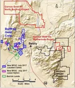
I have another map from Another exploration company. Corvus gold projects north-bullfrog.

beatty-region-map.jpg

Interesting it gives indication of smaller gold deposits east.

Could Breyfogole had found one of these smaller pockets of gold?

Kanacki
 

Hello Bill the map in post 77 should expand with a double click. Its quite detailed. Personally I prefer hand drafted maps than the new computer generated maps these days. Probably because I am used to old school. I just think they convey more accurate information.

Kanacki
 

Hello Bill the map in post 77 should expand with a double click. Its quite detailed. Personally I prefer hand drafted maps than the new computer generated maps these days. Probably because I am used to old school. I just think they convey more accurate information.

Kanacki

Amen brother to the statements you posted, I put them in bold. I would likewise opine that the old aerial photographs are much superior to the satellite imagery, the photos being taken at an altitude of some thousands of feet, while the satellite cameras are actually thousands of miles above the surface of the Earth. Old tech was and is superior to the new high tech in some respects.

Please do continue:

:coffee2: :coffee: :coffee2: :coffee2:

You might want to do a fact check on your concept of satellite altitudes ... "thousands of miles above the surface of the Earth" seriously ?
 

You might want to do a fact check on your concept of satellite altitudes ... "thousands of miles above the surface of the Earth" seriously ?
According to: earthobservatory.nasa.gov/features/OrbitsCatalog
"The semi-synchronous orbit is a near-circular orbit (low eccentricity) 26,560 kilometers from the center of the Earth (about 20,200 kilometers above the surface)".
20200 km = 12625 miles. I don't know about you, but for me that qualifies as "thousands of miles".
 

I do not know much about Altitude but I know attitude ......:laughing7:

Here is a link.

https://upload.wikimedia.org/wikipedia/commons/b/b4/Comparison_satellite_navigation_orbits.svg

https://www.nasa.gov/press-release/nasa-satellite-camera-provides-epic-view-of-earth

Now that said Google does *not* operate its own satellites, but the satellites that provide imagery to Google include GeoEye-1, QuickBird, WorldView-1, WorldView-2, and others.

GeoEye-1 orbits the Earth 15 times per day flying at an altitude of 681 kilometers or 423 miles. Likewise, QuickBird and WorldView-1 are basically at the same altitude of 450 and 496 km respectively. Note QuickBird-1's orbit decayed in Jan 2015 when it re-entered Earth's atmosphere. QuickBird II (or QuickBird-2) is still in operation.

WorldView-2 is at a higher altitude of 770 kilometers or 478 miles.

Kanacki
 

Last edited:
You might want to do a fact check on your concept of satellite altitudes ... "thousands of miles above the surface of the Earth" seriously ?

I stand corrected, change "thousands of miles" to say "several hundred miles". I stand by the whole point of the statement however, that aerial photographs shot by airplanes usually flying at 20,000 feet have greater detail and accuracy than the satellite images available to the public, taken by satellites flying at several hundred miles above the landscape. Don't take my word for it, compare some images for yourself. The old aerial photographs were and are superior to the satellite images we can get. Perhaps the military grade spy satellite imagery can match the aerial photos, can't address that as we don't have access to their best quality photos.

:coffee2: :coffee2: :coffee: :coffee2:
 

Another version of the tale online:
https://www.legendsofamerica.com/lost-breyfogle-mine/

Yet another site associated with the lost Breyfogle mine is Panamint City.
Panamint_City%2C_California.gif


Quote
By the middle of July 1907 plans, including a post office, were proceeding ahead full steam for the development of the new mining camp, which was being renamed "Panamint." Over 100 claims had now been staked, with prospectors still swarming over the area. Salt Lake interests were the principal backers of the camp, intending to organize two companies, each with a capital of 1-1/2 million dollars; two more companies were due to organize within another month. Businessmen were commencing at once to sell stock, but would wait until fall to begin actual development work:
the numerous ledges of gold discovered . . have given all a full faith in the camp. They maintain that Greenwater, Skidoo and Lee, with all of their indications, are not ahead of the new Panamint. It is also believed that the famous Breyfogle was found and lost in this section, and that the new discovery is within a few miles of "Scotty's" famous mines.

In short, the prospectors and persons interested in the new discoveries are confident that the Panamints will witness the next excitement in Nevada-California mining. [375]


from Death Valley NP: Historic Resource Study (Section III)

Time for tequila, or are we still on coffee?
source.gif

:coffee2: :coffee: :coffee2:
 

Hello Oro

That tequila goes down nicely.

Well one thing we can get out of this topic that it interesting to see how such stories evolve over time.

Cheers Kanacki
 

Hello Oro

That tequila goes down nicely.

Well one thing we can get out of this topic that it interesting to see how such stories evolve over time.

Cheers Kanacki

I like how the location gets moved around from the Amargosa mine to the Johnnie and back etc. A wee bit of shoe-fitting going on in these many claims of having found the Breyfogle, I am afraid.

Please do continue;
:coffee2: :coffee: :coffee2: :coffee2:
 

This is nearly getting as bad as the LDM. So many different versions.
1) Proponents of the Congress/Johnny mine claims that after he was hit on the head and left for dead, went back to the camp and found his partner(s) dead - he more or less walked NE where he found the spring and the ore - then wandered around for days.
2) He was hit on the head (on the way back after having been shown the vein by the indians) - crawled back to camp - found his mates dead - and then wandered. Did he find the spring/ore after that or did he take some ore from what the indians showed him?
3) Camped a li'l way away from his friends, woke up by indian attack and escaped - wandered around, found spring and ore.
4) (from 2 & 3) walking _south_ looking for the immigrant trail. Ended up in Stump Spring, was enslaved by indians and saved by mormons.

Now, the mormon trail basically went through Vegas and then SW - it did not go anywhere near Stump Spring - Searchlight might be a much better option.
Mitchell claims that he found a desolute camp at a spring on the west side of McCullough mountain (funnily enough - that is where the "Lost Mormon Mine" is supposed to be as well). Now - if you go south from there, sooner or later you are going to hit the mormon trail - again ... Searchlight ...

Funnily enough - very, very little to be found about the lost mormon mine (other than a rehash of the Breyfogle story, different names). Might be worth looking into - at least there are reports of a dead body.

I leave it to all-yall to draw your own conclusions ...
 

Last edited:
According to: earthobservatory.nasa.gov/features/OrbitsCatalog
"The semi-synchronous orbit is a near-circular orbit (low eccentricity) 26,560 kilometers from the center of the Earth (about 20,200 kilometers above the surface)".
20200 km = 12625 miles. I don't know about you, but for me that qualifies as "thousands of miles".

Well, Oro already fixed it. Not all sats do the same things, from the same heights. It is all good :D
 

Hello All

Treasure legends are very interesting and eyewitness accounts seem so seeing is believing. The following lecture questions peoples capacity visually remember events.


In regards to lost treasure stories and lost mine stories we need to be aware of the limits of eyewitness accounts. While indeed many may recounting such events when retold over time details become less clear.

I confess there are times have been guilty of this without even realizing, perhaps like everyone else?

As the old saying goes the devil is in the detail.

Kanacki
 

I confess there are times have been guilty of this without even realizing, perhaps like everyone else?

As the old saying goes the devil is in the detail.

========

I have been guilty myself. Luckily. it was my son that was observant and corrections made. :notworthy:
 

I confess there are times have been guilty of this without even realizing, perhaps like everyone else?

As the old saying goes the devil is in the detail.

========

I have been guilty myself. Luckily. it was my son that was observant and corrections made. :notworthy:

Well I thought I was wrong once myself, but I was mistaken! (OLD joke sorry for that!) :occasion14:

:coffee2: :coffee2: :coffee::coffee2: :coffee2:
 

Top Member Reactions

Users who are viewing this thread

Latest Discussions

Back
Top