The First Four French Expeditions in Florida

Attachments

  • object109.webp
    object109.webp
    45.6 KB · Views: 974
Signumops . Could you ask Gaetan Algoet to take a look at this ....I think Apalatcy are the Apalachee Indians.
 

Attachments

  • How the Natives Collect Gold in the Streams. i.webp
    How the Natives Collect Gold in the Streams. i.webp
    149.4 KB · Views: 926
  • How the Natives Collect Gold in the Streams. i.webp
    How the Natives Collect Gold in the Streams. i.webp
    149.4 KB · Views: 907
Gaetan does Dutch to English and French to English. That looks like Latin, but you're probably right about the native name. On the other hand, at the time, the French were known to be bound northward to Appalachia in Georgia on the hunt for gold, according to Laudionerre. (?)
 

yep apalachee = >) differant spelling * same tribe
 

Do you know what year the maps you posted Gatorfrog are from?I have noticed as they would move around they would use the same names over & over - fort charles & dauphin river..It's all about where they really were in 1564
 

Attachments

  • ASH 138-6-3.HMC.3.webp
    ASH 138-6-3.HMC.3.webp
    92.9 KB · Views: 303
  • french_draweing1704fort594x242.webp
    french_draweing1704fort594x242.webp
    44.7 KB · Views: 311
  • ASH 138-10-7.HMC.3.webp
    ASH 138-10-7.HMC.3.webp
    132.7 KB · Views: 378
Nice maps, Relic!
I noticed it was written in modern French. Bay of Mobile, AL. There was a Spanish encampment there. From the map, could it be west of Orange beach.. ???

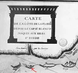
As far the pics I posted, The first one was done by Duval, Pierre (1619-1683) in 1677. the second one is actually a translation of Bellin, Jacques-Nicolas (1703-1772)'s 1744 map.

You're right about using the same names... I can see why they would have "grand marais" or "presqu'isle" as these are descriptive noun (big swamp, peninsula),but Charlesfort....

I was reading another book called A Frenchman in Florida
The author had this to say :
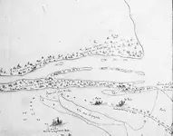
In Mr. Paul Gaffarel's interesting book "French Florida", I have
consulted with fruit for this historical summary, drew up a map of the fort of the
Caroline who disagrees with that of Jacques Le Moyne, on the em-
placement of this fort. It is also in contradiction with the facts. Menendez
crosses the distance of San-Agustino to Carolina in three days, from 17 to the
September 19, and he had to cross than the current San Diego Marsh, and not
the river of May (St John's river). Why Mr. Gaffarel place Carolina
on the left bank of this river, and at a distance such that it must be to the
least five to six days to perform San-Agustino journey to this location-
ment? Of Tocoï, station on the St. John's river, right bank, where the path of
Railway leads you to Saint-Augustin, there are twenty-three kilometres, approximately six
leagues, crossed in two hours by fast, but barely crossed lanes
in a day through woods and marshes. My research led me to think
the location of the fort is located right bank of St John's river, on the Creek
Julington, from Mandarin, thirty-five kilometres from Saint-Augustin.
The entry of this Creek specifically is a triangular Island, any sem-
similar to that which covered the fort of Carolina.
 

gatorfrog done any detecting to on that island verify your theory ? --if so it would be a huge historical and quite an important find - fort caroline was one of the first major structures built in america by europeans.
 

ivan salis said:
gatorfrog done any detecting to on that island verify your theory ? --if so it would be a huge historical and quite an important find - fort caroline was one of the first major structures built in america by europeans.

Hi Evan
That theory is not mine. It's that of the author.
I do some research on that area for forum members who may be in that area and may find information i find here and there interesting.. But for my metal detecting, I'm more focused on the fort pierce to port saint lucie area.
 

Top Member Reactions

Users who are viewing this thread

Back
Top Bottom