Swift Silver??

hiker, been collecting stories and maps on silver/gold and a few diamonds around Kentucky. started on may 6th 1969 when an old friend said you got to read this. it was in the huntington west va. news paper, had one version of the mines of john swift in it. been hooked on old mines around ky. got a dream job no one else wanted. csx railroad needed someone to inspect buildings and machinery on the system. I could go wherever. so I had a lot of time to check different towns, libraries, historical societies and talk to people that new the old stories. (digger) find the book, the big sandy valley
 

Oh, what a job. Probably a good pension too! Yea I was about 4 yrs old when you got started! Its great that you have stuck with it all this time.
 

Old RR towns (abandoned) will often give you "clues"; got one near Roanoke, Va. with @ 3 "Ore" Mines near-by, that MAY be "connected" to Beale Treasure, "legend"; Spec, Va. along RR Tracks. On BRP, it is in Iron Mine Hollow (MP 96.2). US Forest Service Ranger told me that 2 mines are open; one is closed as being TOO dangerous to "explore" NOTHING to do with "SWIFT", BUT!. "Google" Abandoned States: Deep Inside the Iron Mine of Spec, Va. ANYWAY, HH! Good Luck! :icon_thumleft: :coffee2:
 

Last edited:
I'll have to find the picture again but there in the area of Cox cemetery and licking Creek and blackwater Creek the coins were found let me dig it up again but it was on a thread about swift.brb
 

I'm sorry Boomer it was one of your threads and I do not a know why I said Spanish coins it was just "coins found" sorry bout that.
 

digger, no problem. see if library can get the book about the big sandy valley. it was at the library in west liberty and Paintsville. but it was years ago I looked at it. the coins found were French also gold coins were found on spas creek near the mouth and a single coin mold. I think the book tells of a small steam boat that was carrying army supplies up to Paintsville, a confederate cannon shot a hole in the side and the boat drifted a half mile down river from Paintsville and sank. I checked on this, the old records were in the Catlettsburg library and it told about this sinking. it had guns and ammo and cannon on it. I checked the sinking site, if it drifted down it would have hit the bend and sunk. the old records verify this and salvage records show no recovery. so get the book.
 

I was able to read some in the book online.very interesting.seems like there were lots of wealthy people in the paintsville area..hmmm
 

digger it was levisa fork. one thing I forgot to talk about, there was a photo showing the smoke stacks sticking out of the water. I think there were two, looked to be above water about 2 feet and looked to be in middle of channel. donot have date, but the photo was vary old. maybe after it sunk? I saw the picture in a book had something to do with local history. I kept no record about this. as for the coins. its been told about in two books. I used a wide bottom flat boat to get to same of those places. vary good investment. near cold cave branch at the head, just to the east is spas creek its a hard place down in that gorge. its best to go around by licking river. before spas is a branch called devils branch. their is a mine hidden there. worked by walter boggs in the 1930s. he reopened it after finding a furnace while hunting. a set of money molds were found on open fork of spas creek. I did find a few flaks of gold near the mouth of spas, but there are three creeks that come together there. hello james
 

1500085008402750598405.jpg


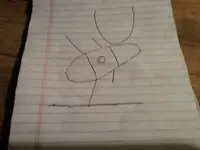
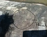
I ran into a rock carving that looked like this today. Just to the left of it is a Left Hand. The hand isn't like a picture of a hand, I could put my hand inside it and it is contoured , looks like somebody just pushed they're hand into the rock. I'll upload pictures soon, I didn't have my phone with me today. Any ideas?

I thought it was cool that my hand fit in except the pinky finger was 3/4" inches shorter.20170715_172626.jpg20170715_133530.jpg
 

Last edited:
View attachment 1472484


I ran into a rock carving that looked like this today. Just to the left of it is a Left Hand. The hand isn't like a picture of a hand, I could put my hand inside it and it is contoured , looks like somebody just pushed they're hand into the rock. I'll upload pictures soon, I didn't have my phone with me today. Any ideas?

I thought it was cool that my hand fit in except the pinky finger was 3/4" inches shorter.View attachment 1472727View attachment 1472728

Hi Brushy Bandit,

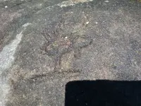
The hand of a man is telling you to stop and look for the next directional marking. That would be the drawing like an elk or something on it's hind feet. You can either go in the direction it is pointing with it's raised feet or head, which most likely is South. But if you look on the top of the Elk where the antler's are you will find written, "EAST" with the "T" as and antler pointing at a 90 degree from the direction from which the Elk is heading. So I would say go around the rocks to the right then turn 90 degrees to the EAST. There is also writing under the ELK's Feet-------I can not make it out. It most likely is the distance you need to travel. I hope I have helped you.
 

I see a circle inside another circle above the crude buffalo or bear shape and not the U shape that was drawn. I don't see any writing that resembles english.
Sometimes splashing water on carvings like this will reveal more detail, I have also waited for overcast or late day lighting and shined a flashlight across the surface of carvings for more insight.
 

Last edited:
I see a circle inside another circle above the crude buffalo or bear shape and not the U shape that was drawn. I don't see any writing that resembles english.
Sometimes splashing water on carvings like this will reveal more detail, I have also waited for overcast or late day lighting and shined a flashlight across the surface of carvings for more insight.

These pics were takin with water splashed over. The U looks like a circle in a circle cause of the width it's as wide as your finger. I'm open to suggestions tho. I'll get more pics from different angles. Thanks Hiker
 

20170716_194803.jpg

20170716_203559.jpg

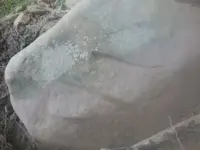
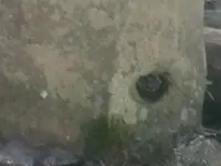
In the top picture there are 3 lines the top line forks at the left end. Looks almost like the bottom 2 lines are joined and make a triangle? The second picture, possibly a sight hole? You have to lay on the ground to look through it.
 

Last edited:
I would think the hole could be more modern in that a wooden shaft and pulley could be used in it. Depending on the weight of the stone, a rope and pulley or hoisting system of some sort. The marks could be any language. I came across these videos on carvings and petroglyphs in Clay co. interesting. They might help you. Also last one is a fun drone video of nearby area.


Top Member Reactions

Users who are viewing this thread

Back
Top