South Padre Island/Port Mansfield.. need help IDing structure on map!!!

  • Thread starter Thread starter fishunter92
  • Start date Start date
F

fishunter92

Guest
I recently got bit by the treasure hunting bug, and I can think of no other place to start hunting than on SOuth Padre Island and Port Mansfield area of the beach. I've done research on the beach and know that the Singer family lived on there and raised cattle. I also know they had several ranch outposts located at various points on the beach.
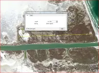
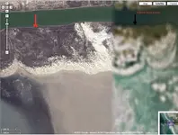
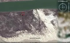
I fish so much on the beach that I decided to use a satellite to give me a bird's eye view of it. On the north end of South Padre Island there is Port Mansfield Channel. I used the satellite to see the area and noticed what looks like a structure outline. My heart skipped a beat and I felt like Indiana Jones (corny but true) when I saw this.

I was hoping you guys might be able to help me decide whether or not spend the time/money in exploring that area. I have a boat and can get to the area rather easily. I plan on buying a metal detector soon and have big plans on exploring the island. Any thoughts, help, advice would be greatly apreciated.
 

Attachments

  • PM aerial view 1 copy.webp
    PM aerial view 1 copy.webp
    32.9 KB · Views: 1,186
  • PM aerial view 2 copy.webp
    PM aerial view 2 copy.webp
    29.5 KB · Views: 1,036
Neat find. Thats wh it looks like. Awfully big.

Keep us posted.

Burt
 

Upvote 0
To me - the second picture looks like what was a fenced area... like any sectioned or portioned parcel you might see from satellite photos. The theme is carried over on the land across the channel, which looks like it was cut through the property.

Thats what I see... However I know nothing of the area or the size or distances dipicted.

You say you have fished there... what do you see when on the ground in that area? What makes you think it may be worth searching? Do you think that area was ever more than a field?

It's kinda interesting... I'll be watching this post to see what others say.
 

Upvote 0
Google earth image of it. there appears to be some structure close to the water but it looks like it might be a duck blind to me.
 

Attachments

  • Island2.webp
    Island2.webp
    51.1 KB · Views: 982
Upvote 0
Using Google Earth map and its distance/length gauge, I estimate the length of the rectangular "fenceline" to be 2750ft x width 850ft!! That's a big ass duck blind if I ever saw one. haha j/k I remember hearing stories about Singer and his numerous outposts all over the island, made to let the herds of cattle free graze within their boundaires. He was also supposed to have made the barriers/borders out of driftwood.
I also noticed the similar structure on the other side(northern) of the channel. I need to know if it was built as an area to house the materials and machines needed to dredge the channel and build the jetties, or if they found a ranch and decided it was suitable to build the channel thorugh there.
I've never set foot on the ground around that area, but have gotten to within one mile of it. I fish that area as often most people take cut their lawn. My 4x4 is suited to travel on that sand, and can only hope someone from down here (Rio Grande Valley) will contact me to set up a scouting trip.
Like I said, it's very easy to get to by boat, one of which I have.
 

Upvote 0
Here is a slighty better google map with distance reference.
 

Attachments

  • fencelength PM channel.webp
    fencelength PM channel.webp
    83 KB · Views: 1,017
Upvote 0
if in doubt --check it out---thats my motto ;D -- you never know what you might be missing out on otherwise. Ivan
 

Upvote 0
ivan salis said:
if in doubt --check it out---thats my motto ;D -- you never know what you might be missing out on otherwise. Ivan

heh...Mines always been "if in doubt...Whip it out" ...um....well i will leave it at that.
 

Upvote 0
thats how you wound up with the youngin your kissing I guess---- never know what you might be missing out on---like fatherhood and the joy and pain that kids bring you-- ;D Ivan
 

Upvote 0
ivan salis said:
thats how you wound up with the youngin your kissing I guess---- never know what you might be missing out on---like fatherhood and the joy and pain that kids bring you-- ;D Ivan
;)
 

Upvote 0
fishunter92 said:
Using Google Earth map and its distance/length gauge, I estimate the length of the rectangular "fenceline" to be 2750ft x width 850ft!! That's a big ass duck blind if I ever saw one. haha j/k

Isn't everything bigger in Texas ;) Actually the thing I thought was a duck blind is circled in this pic. if you zoom in with google earth you can get a better view of it.
 

Attachments

  • Island2.webp
    Island2.webp
    34.4 KB · Views: 719
Upvote 0
Ive been out to the Mansfield cut several times. Things look so much different once you are there than when you see a birds eye view of it on google maps. >:( 
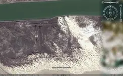
I tried looking for the mud flats where the dredgers dumped the leftover dredge materials. Never found it! lol How far is this area from the jetties?
 

Upvote 0
Is this North or South of the cut? I have been down from the North many times. Just North of the cut were a couple of Hatch covers about halfway betwen the two bodies of water.
There were also some corrals from the wild mustang days. Mustang Island
I tried it up from the South,Port Isabel, but got too low on gas to risk the last 4-5 miles. In those days, Port Isabel businesses closed at 6:00 pm including the two gas stations.

On the gulf side, less than a mile North lays the wreck of the Nicaragua, about 100 yds off the beach.
Good luck, but I bet it's corrals.
One more possibility would be the work camp for the dredge crew.
 

Upvote 0
If map is being seen with north facing up... then i beleive this is the southern part. Could be wrong. Zoomed in too far to actually tell.
 

Upvote 0
i found something similar a little further inland on the southern part of the cut. Do u think its from when the channel was being dredged? Interesting stuff!!! :icon_thumleft:
 

Upvote 0
Dear group;
What everyone is seeing is an old Naval *P* field that were used to train Naval pilots (aviators) during World War II. They were unmanned airstrips and used only to practice touch & goes, if memory serves correctly.

Also, the dredge spoils from the land cut are right next to the channel proper. As I recall, the way they used to *dredge* the channel out was to run one of those huge ocean-going tugs through the channel. That monster screw (propellor) would churn up the silt and mud and scoop out the channel.

Using a tug in that fashion tends to keep the spoilage flat and disperses it over a widely fanned area, whereas using a suction dredge tends to pile the spoilage in a high pronounced ridge, whereby the spoilage slides down upon itself and fills the channel back in upon itself, in much the same way that a mudslide occurs on a hill slope.

I remember when the local government attempted to dredge out Packery Channel in the very early 1970s. They used a suction dredge mounted on a barge and they ejected the spoilage off the sides. The channel was so soft that it was closing in behind the dredge and without jetties extending out into the Gulf, keeping the channel opened was impossible. The dredge had to dredge it's way to the Gulf and then it turned around and had to dredge it's way back to the lagoon. 8)

I've heard that they've recently jettied the mouth of Packery out to the Gulf and with the Gulf currents being quite swift, the channel should be self-dredging or at least self-clearing now.
Your friend;
LAMAR
 

Upvote 0
Not doubting you Lamar, but my Navel Avaition mechanic stationed at Corpus NAS and Kingston NAS from 49 to 51 says he doesn't remember any touch & go strips on the island. Also it seems that it would be impossible to keep it sand free. Remember..until the SPID bridge, the only way down there by land was the hand raised draw bridge @ the North end.
Now I am back to my original theroy...Cattle pens or horse corrals. The island was a cattle range until after the Nat'l sea-shore thing.
M.D.'s are forbidden (big sign at entrance) acording to the ranger lady, because we dig holes on the pristine beach. I pointed out that a 4yr old with a spoon and a beach bucket digs deeper holes that I do with my sand scoop. Just like telling obama that I can't pay for anymore hoax and chains.
 

Upvote 0
kenley said:
Not doubting you Lamar, but my Navel Avaition mechanic stationed at Corpus NAS and Kingston NAS from 49 to 51 says he doesn't remember any touch & go strips on the island. Also it seems that it would be impossible to keep it sand free. Remember..until the SPID bridge, the only way down there by land was the hand raised draw bridge @ the North end.
Now I am back to my original theroy...Cattle pens or horse corrals. The island was a cattle range until after the Nat'l sea-shore thing.
M.D.'s are forbidden (big sign at entrance) acording to the ranger lady, because we dig holes on the pristine beach. I pointed out that a 4yr old with a spoon and a beach bucket digs deeper holes that I do with my sand scoop. Just like telling obama that I can't pay for anymore hoax and chains.
Dear kenley;
My dad patrolled the island throughout WWII with the USCG. I was born in Flour Bluff so yes, I remember the old JFK causeway very well, and actually it was two separate drawbridges but most people thought it was only one because they were so close together. And it was not called SPID back then either. It was known as Lexington Boulevard. It was connected to the Crosstown Expressway at Ayers and Lexington and the name was not changed to SPID until it was completed in 1973.

Metal detectors have been illegal on the National Seashore (Little and Big Shell) since at least the late 1970s and as far as I remember, that particular law came into effect around 1969 but it wasn't enforced until the late 1970s. The reason for the law is to attempt to preserve artifacts from pilferers, or that was what they told everyone back then.

My dad pointed out the remains of the old P fields to me along with the remains of the artillery shore battery placements that dotted the beach front. If you look closely at the sat photos, you will notice that the construction layout is the same for all of them. You can see the remains of the strip and the fences, which is all there ever was to the fields. As I stated previously they were completely unmanned and unlit. In fact they were nothing more than paved strips. As I was growing up I remember at least 15 operating P fields around CC, with Cuddihay, Cabniss, Waldron and Rodd fields being the largest, along with many other smaller fields dotting the area.

I remember cattle grazing on the beach during the 1960s, but not on the National Seashore. I think that they stopped allowing grazing there in the 1950s and the rest of the island followed suit in the 1960s, with St. Joe having the last cattle grazing at least until the 1970s and possibly later.
Your friend;
LAMAR
Your friend;
LAMAR
 

Upvote 0
lamar might have a good point. The other one I saw is similar to the one on the sat photo. They have the same rectangular shape and a line going down the middle.
 

Upvote 0

Top Member Reactions

Users who are viewing this thread

Back
Top Bottom