Searching for a Buried Cannon in Pakistan

Zamzama

Jr. Member
Apr 21, 2020
23
9
Primary Interest:
All Treasure Hunting
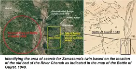
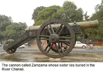
The sister of a cannon named the Zamzama which was cast 260 years ago sank while being ferried across a major river in Pakistan. i need help / advice on how to locate it and what would be the best detector to use. The Zamzama is on display in Lahore and its barrel is made of copper and bronze, weighs 4.5 tons and is 14 feet long. The river as changed its course since the sister of the Zamzama sank and the area identified for the search is now heavily cultivated and the soil is loam (clay, silt & sand). The floodplain of the river is prone to flooding and depositing layers of silt/loam and the barrel may be 10-15 feet below the surface. i have marked out an area of 6 km by 3 km and i presume a grid would have to be surveyed and marked before commencing the search. I have no experience of searching for buried objects and would certainly need expert help / advice. [SUB] Zamzama.jpgWAZIRABAD XING.png[/SUB]
 

Upvote 0
Ground Resistivity Tomography gives superior data compared to most, if not all, metal detectors and is no. 1 work horse in professional geological and arceological studies. It gives not only the position, but also a clue about size, shape, orientation and material of the target; such things as voids soil layers and water can be detected and tell apart. One of the draw-backs, beside the price of the instrument, is not all terrains permit this method. But this is not the problem in your case. The other down side is time and effort spent to sistematically scan large areas. Suppose you have a sistem that support an array of 100 probes. You would need to mark the 100 m2 area and stick a probe in each square meter in the same distance to each other, wire all probes to the instrument, run a scan and evaluate the data obtained. Than move to another area of 100 m2 etc.. So if you need to search 6 Km2, it pays to narrow down the areas that deserves a closer look, with some other, faster method first.
 

Thanks GreenBoy.......... i am now pretty clear. i can see its going to be a long haul if i undertake the project
 

Just go for it! actually finding a cannon is a bonus, not mandatory.:icon_thumright:
 

Just go for it! actually finding a cannon is a bonus, not mandatory.:icon_thumright:

I really appreciate your spirit............ its the fun of the chase........... and am with you ........will keep you posted
 

Resistivity is not appropriate for searching large areas for compact targets. I wasn’t sure from your post how accessible the site is. If cost effective instrumentation that can scan a large area is your requirement, then I would probably use a real geophysical instrument such as an electrical conductivity profiling instrument. An example of this is a Geonics EM31 that will detect any conductive target up to 20 ft in depth. I would combine it with a reasonably accurate GPS receiver, my preferred value receiver is a Juniper Systems Geode which should have accuracy of about 50 cm where you are. I would use QCTool software from PetrosEikon in Toronto, Canada to process and map the data. Let me know if you have further questions.
 

Absolutely beautiful cannon and looks like a real brute in actions. Probably take down castle walls without any problems.
 

Top Member Reactions

Users who are viewing this thread

Back
Top