Searching for a Buried Cannon in Pakistan

Zamzama

Jr. Member
Apr 21, 2020
23
9
Primary Interest:
All Treasure Hunting
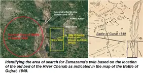
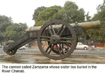
The sister of a cannon named the Zamzama which was cast 260 years ago sank while being ferried across a major river in Pakistan. i need help / advice on how to locate it and what would be the best detector to use. The Zamzama is on display in Lahore and its barrel is made of copper and bronze, weighs 4.5 tons and is 14 feet long. The river as changed its course since the sister of the Zamzama sank and the area identified for the search is now heavily cultivated and the soil is loam (clay, silt & sand). The floodplain of the river is prone to flooding and depositing layers of silt/loam and the barrel may be 10-15 feet below the surface. i have marked out an area of 6 km by 3 km and i presume a grid would have to be surveyed and marked before commencing the search. I have no experience of searching for buried objects and would certainly need expert help / advice. [SUB] Zamzama.jpgWAZIRABAD XING.png[/SUB]
 

Upvote 0
Thanks so much GreenBoy. i was hoping for advice from someone like u who has the experiance of searching for large and deep objects. After so much advice coming in (for which i am sooooooooooooo grateful) i am being drawn to the conclusion that it may be advisable to use two different types of detectors if sufficient project funding is available. That is another side that i have to seriously consider. warmest regards
 

Dear AARC....... i am looking for a cannon for sure and being new to this science, am relishing all the advice coming my way. i find the certainty with which you speak very exciting and makes my confidence level jump
 

oh yes yes coinboy..........will certainly inform you but it will be a couple of years from now. need to do more research on where is could have sunk and org funding.
 

That is an important part of my research but still dont have an answer. i suspect it was during the Monsoon season (july-sep), when the rivers rise to flood levels and currents are fast. in winter they are placid and break up into smaller channels and less chances of the ferry sinking with the gun. Zamzama
 

Thanks ...........i found the detectors you mentioned on the net except DBP2010. can you please send me a link.
Zamzama
 

This is how i do it (my personal approach):

first, i use DBP2010 with 1m x 1m coil with settings to ignore all metal items smaller than, say a beer can. In this settins the machine will report large targets up to good 2m depth. I mark the areas with signal. Than i connect the smaller coil (38cm oval in my case) with settings pushed to the limit of detector's stability. The max depth is now again around 2m, but all small items will be reported. If there is no signal with the small coil on a designated area, it means there is at least one large target deeper than 2m. This area is documented and mapped for "better times", but i never dig 2m+ targets, unless there are additional favorable data besides the detecting part. Offently, i can identify many small targets on a designated area, they fake single big target signal when under the large coil at the same time. I disregard such areas. And finally, i identify large items with the small coil, by tracking the signal at the target's edges i estimate size and shape, by lifting the coil at max signal point it's depth is estimated.

I also own a simple home made earth resistivity meter, but due to the rocky and difficult terrain, i seldom ever use it. In river sediments, however earth resistivity tomograph would offer an extra value view. Proffesional toys are valued 10.000 EUR ++ but good side is there are companies where the instrument and personall could be hired, and they usually produce an A+ scan report with interpretation.
 

Dear EccentricinTexas...thanks for putting me onto the Resistivity Survey Meter. Useful device and i will need it as the initial area is 3x6 km. and bigger if i dont locate the cannon in this rectangle. Regarding the location of the river channel 260 years ago when the cannon was lost, i am putting in a request with a govt space org for a Satellite SAR image. which may show the old channel. Will certainly post pics if i hit jackpot.......... zamzama
 

Dear EccentricinTexas...thanks for putting me onto the Resistivity Survey Meter. Useful device and i will need it as the initial area is 3x6 km. and bigger if i dont locate the cannon in this rectangle. Regarding the location of the river channel 260 years ago when the cannon was lost, i am putting in a request with a govt space org for a Satellite SAR image. which may show the old channel. Will certainly post pics if i hit jackpot.......... zamzama

Why not LIDAR... ?

IT WILL show the old river channels.
 

Thanks AARC..........I did not know about a technology called LIDAR but have now read up on it a little. Thanks for telling me. There is so much i am learning from you and the other members taking an interest in my project. i dont think LIDAR technology is avail in Pakistan and i suspect that a drone mounted device (if it can do what we require) with the right type of sensor would cost a fair amount.
 

Excellent........ thanks so much ..... as they say a look is worth a thousand words:icon_thumright:
 

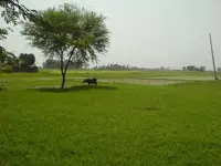
Hey TheGreenBoy...thanks a million for sharing your method with me. it sounds very logical and methodical. i am attaching a pic of the area which as you can see is flat and cultivated with little chances of getting false signals or small items. Sadly i dont think i would be able to find a company in Pakistan for a scan report but will look. wheat fields.jpg
 

Have you decided about your tool of choice yet?

HEY Geenboy...........thanks for asking .........sorry for my late reply but i was doing some research on the project and letting things sink in........ i think i will go for the Deep seeking PI with large 1m x 1m frame coil probably a pulse star II, and a smaller 18 inch coil
 

He GreenBoy…….. you have said in this post that when searching with a large coil, if there are many small targets within a designated area, they can fake a signal of a single big target. How then does one make out that this is a fake signal of a big target?
 

If a couple or more of small (i.e. a few cm in diameter) shallow targets comes under the field of a large coil, it will set the detector off even with settings to ignore small items. You will find two or more hits with small coil close enough to fall under the large coil area or near it. This will tell you it is more than one, probably shallow and small targets, rather than big deep one. In theory, however, it is possible to have many small targets over a large one, which cannot be resolved unless small targets are dug out, and area checked with the large coil again. Luckily, this situation occures rarely in reality.

If the cannon is not too deep (les than 2m) you may even find one large elongated target with the small coil. In my area this is usually a signature of a non exploded WWI 380 mm grenade or WWII avio bomb - something not ot be desturbed. But than again, pulse star II is able to discriminate iron/non iron, so you should be able to tell.
 

Last edited:
GREENBOY...…. I continue to be in your debt for giving me so much of your time and sharing so much information. in my part of the world a person like you who is so helpful we call a 'diamond' (in Urdu the word is Heera):laughing7: I am now very clear on how to differentiate false signals. As you would have understood, this is a large project in terms of time and money and I am trying to get the government interested in it. If they do agree then I will have to put a team together to do research on the possible location(s) of the cannon and then search the sites (s). it will in my estimate require 3-4 teams with metal detectors (both large and small coils) working concurrently and following the process that you have so nicely and carefully explained. The question that I want to ask is this: Should I have the site(s) first scanned with an earth sensitivity meter (ESM) and only use the metal detectors where the ESM indicates the presence of large objects? Each site area (and there may be 2-3 sites) may be 3km x 6km. How much area does an ESM cover? Warmest regards. Zamzama
 

Top Member Reactions

Users who are viewing this thread

Back
Top