SATELLITE IMAGES

So how/where does one go to source Lidar imagery of a given area? I have an area I'd like to metal detect but this certainly sounds like the place to start on the macro side of things?
 

Is there a site where I can pay for LIDAR satellite imagery?
 

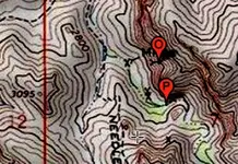
I found a mapper for gps coords on old topo chart land and sea. I tried getting gps off 2 zoomed in GE satellite images for same location looked at on IR satellite (Needle Cayon IR}. The top pin almost covered up word MINE.
 

Attachments

  • Map_Topo_NeedleCanyon_1Crop.jpg
    Map_Topo_NeedleCanyon_1Crop.jpg
    373.6 KB · Views: 51
Hello A-RON, yes, I would like to see that klm file that you got from Okie Send it to my email address: [email protected]. We also use data that Issac sends us. I will text you later on this afternoon.
 

Top Member Reactions

Users who are viewing this thread

Latest Discussions

Back
Top