Prospectors Research Tools

Clay Diggins

Silver Member
Nov 14, 2010
4,958
14,504
The Great Southwest
Primary Interest:
Prospecting
Prospector's Research Tools

I haven't been around much this summer and with the desert prospecting season just starting it's a good time to show off what I did this long hot summer. I have been working with a few friends on a new non-profit organization to give you a single place for all your land research.

The result is MyLandMatters.Org. This is the gateway to your land information repository. Maps, books, tutorials, community resources and quality, easy-to-access information about the land around you.

No ads, No memberships, No log-in required. :thumbsup:

This past spring while sitting around with some friends we came to the conclusion that most of the important and useful things that we want to know about the land around us was difficult to locate and tough to understand. Despite the many sources of information there was no single place to find the information available.

We decided we could do something about that. We agreed to put our time and energy into creating a single place that anyone could find the answers to questions about the land.

It's a big project. It has taken a lot of work, learning and resources to get things started. But after six months of long days, and more than a few nights, the Land Matters repository is ready for you to use.

Land Matters is all about the land. You can find Land Status Maps, Active Mining Claims Maps (with live direct links into the current LR2000 claims database), A great collection of mining books, Land Laws, Geology books and maps, Forest Travel Plans and a whole lot more.

Land Matters is for land users. Our collections are guided by community input. That's you. Let us know what kind of material you would like to find in our Library or a particular map you would like to see. Help us build Land Matters to best serve the community.

We've already got a lot of things that prospectors have been asking for - the claims maps alone were almost universally requested. Land Matters isn't just for prospectors and miners. But you can help prioritize our efforts and drive the content of Land Matters. Prospectors now have a unique opportunity to help guide and build an information resource designed by prospectors and for prospectors.

We are just getting started filling the Library but there will be hundreds of books, maps and items added in the next few weeks. We've even got a Newsletter so you can get regular updates about new additions to the Land Matters repository.

Check it out and let me know what you think. Here are a few good places to start:

Tutorials - the current focus is on understanding Land Status.
Maps - We all like maps and we've got some you will love.
Library - search for something.

Heavy Pans
Barry & Leigh
 

Upvote 12
As many of you know Land Matters updates their free online mining claims maps twice a month.

Normally we get updates from the BLM servers in Denver on the 2nd and the 16th of each month. We just received word today that the BLM has been having difficulty with their database updates for the last month or two and now it's affecting their partner delivery system. Best estimate right now is we will see updates by end of day tomorrow January 6th.

If you were wondering when the claims map update is coming or when the Claims Advantage Member reports will be available now you know. We will bring those updates to you as soon as we have the information.

Heavy Pans
 

Thanks for the info Clay , I will be getting a membership soon to land matter .
 

well the people at Mohave Prospectors seem to be getting on board with LandMatters! I introduced a couple of them to the site and it's starting to snowball! I was asked to do a handout and I will be including the address for the site as well as several others handy sites in it. Wanna guess which one will be on the top of the list?
 

Last edited:
well the people at Mohave Prospectors seem to be getting on board with LandMatters! I introduced a couple of them to the site and it's starting to snowball! I was asked to do a handout and I will be including the address for the site as well as several others handy sites in it. Wanna guess which one will be on the top of the list?

Thanks Jeff! :thumbsup:

Land Matters use is way up the last two months. We're serving in the range of 1,000 maps per hour pretty consistently now.

The more the merrier. :laughing7:

Heavy Pans
 

I'd be expecting the library section to be getting some more hits as well once this handout goes out to the club. We've got a lot of people in need of learning some map reading skills so I directed them to the copy of FM21-26.

I just finished writing it up and Land Matters is the first site listed in the reference section. It was hard to know just how much information to put in the hand out when it comes to finding ground to prospect. I sure wasn't going to give them a copy of all my research since most wouldn't know how to use it anyway. I did cover research, due diligence requirements, staking, testing and filing pretty well but left some room for them to do some learning on their own.

I also put my e-mail address in it for those that have further questions. I guess I'll find out how big a mistake if any that will turn out to be.
 

Last edited:
Land Matters Mining Claims Maps are all updated now.

The BLM was very late this month but we stayed up late last night to make sure you could have first crack at the updated maps. :thumbsup:

Lots of good ground opening up this season. In New Mexico some of the best areas are opening up. At Rich Hill in Arizona more than 200 acres opened up and I'm expecting another 500 acres to open soon. :hello:

Heavy Pans

How about "CO the slow"?
 

Clay I had a question regarding claims if I have a gold claim can anyone else claim a different mineral like quartz on my claim area?
 

Clay I had a question regarding claims if I have a gold claim can anyone else claim a different mineral like quartz on my claim area?

Mining claims apply to all the valuable minerals within the boundaries. No one else can prospect or mine on a valid mining claim without the owners permission. It doesn't matter what mineral the claim was made for all the valuable minerals belong to the claim owner.

Here's how the mining law states that basic principle:
1872 Mining Act said:
the locators of all mining locations... shall have the exclusive right of possession and enjoyment of all the surface included within the lines of their locations

There's a lot more to the law than that and I would encourage you to read and understand all the rights and responsibilities involved whether you own a mining claim or are prospecting for your own mine.

You can read the 1872 Mining Act HERE.

Heavy Pans
 

Sage Grouse Withdrawal Map and Report

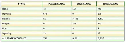
The Sage Grouse Proposed Mineral Withdrawal by the BLM would close nearly 10 million acres of land to mineral entry. This affects claims in 5 western states.

Friday the 15th of January (this Friday!) is the deadline for comments on the proposal. Generally comments and opinions don't apply to the Secretary's decision but with the time near and facts on hand a little attention by more than a few voters and representatives might just convince the Secretary to think twice.

If the withdrawal goes ahead no new claims can be made in the withdrawn area. In addition the existing claims are likely to come under greater scrutiny and challenges to their validity. That puts nearly 7,000 mining claims in the sights of the BLM land managers.

Now is the most effective time to share your opinions and present facts to influence the outcome. With little time left the Secretary will have less chance to bring influence or political pressure to bear on members of Congress should they object.

Land Matters has been working hard to figure out how many and which claims will be at stake should the withdrawal be approved. We've produced a comprehensive report on all the claims affected in this proposal and made an interactive map with just the claims within the proposed withdrawal area.

The BLM did not assist in the preparation of this report. We spent considerable time and effort in hand mapping the location of these claims in relation to the proposed withdrawal. I could find no evidence the Secretary even knows how many or what claims would be affected. I'm sure she and your representatives would appreciate being informed of this information to help their decisions to be made on all the facts available.

This is a factual report that you can not only view online but there is a zipped download available directly from the reports front page. At a mere 159Kb in size this report can be shared by email quite easily.

Why not look over the whole situation and check in with your representatives to make sure they know the facts about the potential effects of this withdrawal should it be approved.

The new custom interactive Sage Grouse Proposed Withdrawal Map shows just the claims affected with all the claim information normally found only on the Land Matters Mining Claims Maps.

Be sure to read and download the interactive Sage Grouse Proposed Withdrawal Report too.

To give you an idea of whats at stake with this withdrawal look over this summary chart from the report.

Screen shot 2016-01-13 at 4.05.19 PM.png

Heavy Pans
 

Last edited:
Mining Clams Maps updated to January 15 2016

As they do twice each month the Land Matters Mining Claims Maps have been updated.

Not much change in California or Colorado this time - more on that later.

Arizona had some big closures in Mohave and La Paz Counties. Nearly 1,600 claims total.

New Mexico continues with the closing of a lot of claims in Sierra, Catron and Grant Counties.

Nevada topped this list again with more than 2,100 closed claims.

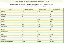
The most recent Claims Advantage Report is showing there have been 26,689 closed since last September 1 with at least 18,904 still to be determined. The bulk of those undetermined claims are in California, Colorado, Nevada and Wyoming.

Percentage wise California is the big hold up - they have processed 46 claims in the last 4 1/2 months with at least 3,477 claims still to go. That's a little more than .01% of their job done after more than 1/3 of the mining year has passed. :BangHead:

Heavy Pans
 

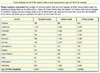
Here's an example of where each BLM State Office stands in their annual claims updates. This is from from the Claims Advantage Report that went out to members yesterday.

Claims1_15.png

Open up the image and you can see how well each state office is doing.


These are the number of claims already closed this year.

Screen shot 2016-01-17 at 1.47.24 PM.png

Obviously California has a long way to go. At this rate they will still be finishing the remaining 3,477 claims from September of last year in 2046. :BangHead:

This claims case work they are supposed to be doing is already paid for directly with claims fees. At some point (soon?) there will be a flood of closed claims and they will all be backdated to September 1, 2015.

Heavy Pans
 

Leigh is doing some updates to the Public Land Survey databases today so there may be some glitches and missing information on the PLSS map layers from time to time. If you have a problem just wait a minute or so and reload your map and it should come back faster and more accurate than ever! :thumbsup:

Heavy Pans
 

Love the updates on the PLSS layer Clay! Tell Ruby thank you very VERY much! I've been wishing for the quarter/quarter section display and it looks great!!!!
 

I swear I used to be able to see blm "lots " labeled in areas with weird angles and patents mixed in. That caused there to be "lots". And for he life of me I can't figure it out again....was I mistaken. I swear I remember something labeled " l3 " or something. What am I not doing
 

The PLSS updates are just getting started. This has been a multi year effort on our part to bring the PLSS up to date. The previous PLSS map files were abandoned in about 2009 and the new CadNSDI land survey is still being completed.

The old abandoned PLSS is whats still being used on all the other web map sites, including the BLM, Forest Service, USGS, Google and all the others. The old PLSS is not very accurate or up to date. The new CadNSDI is much more accurate but there are problems with that survey that have lingered for years. We decided to quit waiting for the government to fix those problems and figure out what would make the new survey usable. You are now starting to see the results of that effort on the Land Matters website.

This is going to be phased in gradually over the next several weeks. All of the maps have the new Meridian, Township, Ranges and Section Survey (first division). Some of the maps already have a working and queryable new second division survey. On those maps you will see a new layer called "PLSS Second Division". With this layer turned on and zoomed in you will see all of the sub section lots, aliquots, unsurveyed protracted, unsurveyed unprotracted and lots of miscellaneous things like aliquot remainders etc.

That's where your "l3" went Goldwasher. It's still there but you need to turn it on.

We will be documenting these map layers, how they were derived, what their sources are and a lot more. The important part for now is that these are a lot more accurate, complete and current than the old PLSS you see everywhere else and it is being updated to reflect new survey information regularly. The old PLSS mapping will never be updated.

This has been a huge project and it's far from over. Land Matters tries it's best to bring you accurate up to date land information and this new PLSS is just the tip of the iceberg of what's still to come. :thumbsup:

Heavy Pans
 

The Public Land Surveys (PLSS) are updated on all the Land Matters Mining Claim Maps. Much more to come soon! :thumbsup:

Land Matters servers had a glitch earlier today. The Maps and Library were down for almost an hour. There's a lot of work going on behind the scenes at Land Matters and we try not to interrupt Land Matters users while we are doing that work. Today was the exception and I apologize for any inconvenience it may have caused.

Heavy Pans
 

I didn't even notice any problems Clay. I was on checking out areas near Chloride and it was smooth as silk for me.
 

Top Member Reactions

Users who are viewing this thread

Back
Top