Prospectors Research Tools

Clay Diggins

Silver Member
Nov 14, 2010
4,958
14,510
The Great Southwest
Primary Interest:
Prospecting
Prospector's Research Tools

I haven't been around much this summer and with the desert prospecting season just starting it's a good time to show off what I did this long hot summer. I have been working with a few friends on a new non-profit organization to give you a single place for all your land research.

The result is MyLandMatters.Org. This is the gateway to your land information repository. Maps, books, tutorials, community resources and quality, easy-to-access information about the land around you.

No ads, No memberships, No log-in required. :thumbsup:

This past spring while sitting around with some friends we came to the conclusion that most of the important and useful things that we want to know about the land around us was difficult to locate and tough to understand. Despite the many sources of information there was no single place to find the information available.

We decided we could do something about that. We agreed to put our time and energy into creating a single place that anyone could find the answers to questions about the land.

It's a big project. It has taken a lot of work, learning and resources to get things started. But after six months of long days, and more than a few nights, the Land Matters repository is ready for you to use.

Land Matters is all about the land. You can find Land Status Maps, Active Mining Claims Maps (with live direct links into the current LR2000 claims database), A great collection of mining books, Land Laws, Geology books and maps, Forest Travel Plans and a whole lot more.

Land Matters is for land users. Our collections are guided by community input. That's you. Let us know what kind of material you would like to find in our Library or a particular map you would like to see. Help us build Land Matters to best serve the community.

We've already got a lot of things that prospectors have been asking for - the claims maps alone were almost universally requested. Land Matters isn't just for prospectors and miners. But you can help prioritize our efforts and drive the content of Land Matters. Prospectors now have a unique opportunity to help guide and build an information resource designed by prospectors and for prospectors.

We are just getting started filling the Library but there will be hundreds of books, maps and items added in the next few weeks. We've even got a Newsletter so you can get regular updates about new additions to the Land Matters repository.

Check it out and let me know what you think. Here are a few good places to start:

Tutorials - the current focus is on understanding Land Status.
Maps - We all like maps and we've got some you will love.
Library - search for something.

Heavy Pans
Barry & Leigh
 

Upvote 12
Small Miners Claim Acreage

Thanks everybody, I hope all of you are enjoying your Holiday! :thumbsup:

I had street tacos in another country for Thanksgiving dinner. Ruby got lots of hugs. I love street tacos and hugging Ruby so this holiday trip has been a real treat. :laughing7:

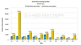
Here's a chart to go along with the Number of acres of Mining Claims by State that I posted before Thanksgiving. Take a look at how the Small Miners are doing in comparison. Seems small miners like Placer Claims. 8-)

SmMineAcre.jpg

Heavy Pans
 

That makes sense to me. Lode mining equipment is costly and placer mining gear for the most part won't break the bank. I did notice a few states where the hard rockers outnumber the placer guys but it's not by a high percentage. While I really enjoy going on tours of lode mines I couldn't work one full time. I've got to be able to see the sky and feel the sun on my face.

(Check your PMs in a bit Clay)
 

What happens to old placer claims when they are closed?

Land Matters Claims Advantage Members have been receiving their twice monthly Closed Claims Reports for about a month now. These reports can be very helpful for someone doing claims research and might be used for several things. Maybe even finding recently opened land for prospecting or mining claims? :thumbsup:

In addition to the twice monthly update reports Claims Advantage Members are mailed a series of Special Reports as soon as they are created. There have been two Special Reports since the Land Matters Membership program was started last month. These reports are about 15 pages long and have State by State interactive tables to help claims researchers.

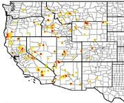
I can't share the reports themselves but with each report Land Matters includes heat maps to give a visual aid in identifying the most active areas. Special Report #1 presented Placer Mining Claims that were closed within the last three years AND were more than 30 years old when they were closed. This was an interesting report because claims that are more than 30 years old are usually considered valuable and worth keeping. Not your average exploratory claim that lasts for a year or two. Useful information for the clever prospector.

Here's the heat map from Special Report #1. The map shows the areas with the most closed Placer claims as a deep red and then fewer claims density are shaded down from lighter red to pale yellow. The smaller black lines are county borders to give you a little better idea where the activity is taking place.

placer.jpg

Although this map is nowhere near as detailed as the full report it does give a good view of where the claims changed and even potentially tracks areas of higher mineralization and claims interest. The report itself shows each claim, 14 data fields per claim and a direct link to the BLM records for the claim.

The Special Report #2 is similar to the first but deals with 30 year lode claims. Neither of these Special Reports or the twice monthly Closed Claims Reports could be created from LR2000 information.

We are working on Special Report #3 now and I'm really excited about what that's going to reveal. The things Land Matters can do with our huge databases is truly amazing. I'll have more info on that report when we get closer to releasing it.

Heavy Pans
 

Last edited:
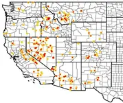
Probably ought to share the lode claims map with you from Special Report #2. :thumbsup:

Same 30 year old claim base as the above Placer Claims report just showing lode claims in this heat map.

lode.jpg

Heavy Pans
 

It appears that our own gubermint is using the strategy of "divide and conquer" against us. it appears to me they think its EZer to beat down a few miners and then use that strategy to knock down everyone else! and it appears to be working for the most part , EXCEPT for those pesky people that put up a fight FOR their RIGHTS ! My hat is off to ALL of them that are doing the fighting for us to bad we cant get everyone on the same page and go after these wacoenviromentalists AND these jelly spined gubermint officials and the BIASED judges that pine for reelection!!!
 

Mining Clams Maps updated to December 1 2015

New updated Land Matters Mining Claims Maps are up and running!

Big changes in Nevada. Another 55,000 plus acres just opened to location!

Check out your favorite area, you just might find a bit of Holiday Cheer! :thumbsup:

Heavy Pans
 

Congrats on the 33K views Clay!:headbang:

Hey thanks Jeff, that's pretty neat! :thumbsup:

I didn't even see that one coming. I started looking around and Land Matters got nearly 400,000 hits last month alone. Served up more than 76 Gigabytes of maps, books, movies and files in November too! I guess the word is getting around? :hello:

No wonder I've been so busy. :laughing7:

Heavy Pans

Ok.... Ok.... Maybe I need to slow down on the research just a little. I know I generated a couple of hundred hits this last month. :laughing7: What do you expect when it's such a great resource? :notworthy: At least I've been sharing the wealth around. :tongue3:
 

Ok.... Ok.... Maybe I need to slow down on the research just a little. I know I generated a couple of hundred hits this last month. :laughing7: What do you expect when it's such a great resource? :notworthy: At least I've been sharing the wealth around. :tongue3:

Um... we did notice Jeff. We are considering getting another server just for you! :laughing7:

Please keep researching all you need - that's what Land Matters is for. :thumbsup:

Heavy Pans
 

Well if you're going to set me up my own server I'll send you the specs! :laughing7:

Actually, I've been figuring out new ways of making the site even more "portable". Hence my research binder(s) are getting pretty thick. When I go to the county recorders office next Monday I may have to haul them in with a hand truck to save my back!
 

Last edited:
Special Report #3

We've been saving up data for Land Matters for a while now. We have a lot of sources for the data we are compiling but the biggest part, most months, is the twice monthly BLM database copies we archive from the BLM server in Denver.

We download more than 3 Gb of database files each month in updates and that allows us to do time based comparisons of the information. That's a whole other dimension of analysis than looking around the LR2000 database.

Besides our twice monthly Mining Claims Maps updates and twice monthly Claims Advantage Closed Claims Reports we have started to publish Special Reports that leverage our database to answer questions that can't be answered by just looking through the public information. That's where we are getting the information to make the charts I've been posting here and the very popular Mining Claims Maps on the Land Matters website.

The latest Special Report answers the question:

How many Placer Claim locations were held for more than 20 years and are now unclaimed?

The basic answer is pretty amazing:

Totals.png

Yeah... that many, that old and that long. That many old historical Placer Claims are not now claimed. Makes you wonder if we are missing something or if in the old days they mined mud for fun. :icon_scratch:

To get the final result we broke these claims down by Quarter Section and took out the obvious withdrawn and now private areas. We checked against current active claims locations. Then we made a 13 page report, broken down by State and County, of each and every one of those claims. These report tables are sortable and each claim has a link to the Serial Register page for their closed case file.

Since we had to use GIS software to make the report we ended up with a map that gives a basic outline of these areas. Even though we are still putting the finishing touches to the report I thought I would put up that map and let you take a quick look around at what 18,835 open claims look like. :thumbsup:

Here's the link to the map:

Special Report #3 Map

Look around. There might be something in your backyard! :thumbsup:

Heavy Pans
 

Hey Clay... Is there anyway that the information windows on the claims maps could be output as a PDF so the entire thing could be printed out? I'm thinking like the LR2000 reports here. Some of the sections I'm researching next to have 32 twenty acre claims and I can't get the bottom part of the information window to print out. That's a lot of information to transcribe to word or excel.
 

Hey Clay... Is there anyway that the information windows on the claims maps could be output as a PDF so the entire thing could be printed out? I'm thinking like the LR2000 reports here. Some of the sections I'm researching next to have 32 twenty acre claims and I can't get the bottom part of the information window to print out. That's a lot of information to transcribe to word or excel.

You can make the window bigger and it will stay that size the next time you open it.

Even easier is to just copy and paste all the results at once into your spreadsheet program. You might have to delete the first column after you do because it also copies the zoom button when you highlight the result text. The links to the LR2000 should be copied in too.

That was probably too obvious? Now you can do the face/palm thing. :laughing7:

Heavy Pans
 

Hey Barry...still learning but I have two problems so far.
#1 On an earlier map you showed a big red dot real close to me. Now it's gone...or maybe now NE of me???

#2 As I zoomed in to confirm #1, the map reverted back to a previous size and will not zoom in again. I have a slow sat link for an ISP and it's storming but???
 

Top Member Reactions

Users who are viewing this thread

Back
Top