Navigation
Install the app
How to install the app on iOS
Follow along with the video below to see how to install our site as a web app on your home screen.
Note: This feature may not be available in some browsers.
More options
You are using an out of date browser. It may not display this or other websites correctly.
You should upgrade or use an alternative browser.
You should upgrade or use an alternative browser.
One Oak Island Answer
- Thread starter Mark Wright
- Start date
Mark Wright
Jr. Member
- Thread starter
- #2
Mark Wright
Jr. Member
- Thread starter
- #3
The solution is in three parts. I'll post the exact coordinates for all 3 parts before the explanations.
Here is the first set. I just tested them so there shouldn't be any problems. Total distance is 483.92 miles.
44.51250635762446, -64.28523114916395
43.831201538320336, -66.14977685162975
41.611860361874335, -71.48513865081655
42.611860361874335, -71.48513865081655
Here is the first set. I just tested them so there shouldn't be any problems. Total distance is 483.92 miles.
44.51250635762446, -64.28523114916395
43.831201538320336, -66.14977685162975
41.611860361874335, -71.48513865081655
42.611860361874335, -71.48513865081655
Mark Wright
Jr. Member
- Thread starter
- #4
To see how this lays out and to solve part 3, plot these coordinates.
42.653784, -71.417584
42.538709, -71.384726
42.526201, -71.423804
42.557416, -71.47871
42.5738, -71.483765
42.576878, -71.498006
42.617406, -71.493527
41.653784, -71.417584
41.538709, -71.384726
41.526201, -71.423804
41.557416, -71.47871
41.5738, -71.483765
41.576878, -71.498006
41.617406, -71.493527
Mark Wright
Jr. Member
- Thread starter
- #5
TruthbeTold
Full Member
- Aug 16, 2023
- 129
- 95
Yet another theory based on random stone picking.
If five oak island treasure supporters here looked at the same stones, they would all come to different conclusions.
If only somebody would post ACTUAL HISTORICAL FACTS about a treasure being buried on oak island in the first place, then there would be a starting point.
In the past we've seen folks here state that the following items are buried on the island:
a) Some sort of random treasure (which has never been defined or backed up with factual historical information)
b) Writings of Shakespeare
c) Sir Francis Bacon's Tomb
d) Aztec Gold
e) Mayan Gold
f) Blackbeard's treasure
g) Other pirate's treasure (fill in the blank)
h) The grave of the fictional King Arthur's brother
i) British payroll
j) The Templar's treasure
k) A space/time portal that the Templars used to travel and take treasure to Mars.
There have been several other treasure types mentioned but the above have been mentioned more often.
Mark Wright
Jr. Member
- Thread starter
- #7
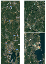
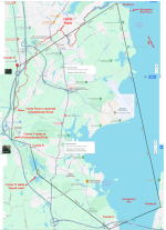
The Oak Island Signpost points directly at the Miner Property in Rhode Island with a 4 decimal point degree of precision.
Unlike Oak Island, no one has generated a legend about a buried treasure on the Miner property. It is a wetland adjacent to a significant river with essentially no possibility of development or treasure hunting.
Unlike Oak Island, the Miner property is pointed at by:
a. Oak Island
b. Rhode Island State, County and Town lawmakers
c. The Boat Stone 184
The 3 pointers to the Miner Plot are glaringly obvious. It’s not a matter of finding them. It’s a matter of following them.
Attachments
Mark Wright
Jr. Member
- Thread starter
- #8
Thak you for your response. I truly do appreciate your input, and I agree with you.Yet another theory based on random stone picking.
If five oak island treasure supporters here looked at the same stones, they would all come to different conclusions.
If only somebody would post ACTUAL HISTORICAL FACTS about a treasure being buried on oak island in the first place, then there would be a starting point.
In the past we've seen folks here state that the following items are buried on the island:
a) Some sort of random treasure (which has never been defined or backed up with factual historical information)
b) Writings of Shakespeare
c) Sir Francis Bacon's Tomb
d) Aztec Gold
e) Mayan Gold
f) Blackbeard's treasure
g) Other pirate's treasure (fill in the blank)
h) The grave of the fictional King Arthur's brother
i) British payroll
j) The Templar's treasure
k) A space/time portal that the Templars used to travel and take treasure to Mars.
There have been several other treasure types mentioned but the above have been mentioned more often.
I hope that by posting everything that I've done, you will give me an exact critique on my process.
I've posted Parts 1 and 2 today. I have 4 more to post plus several explanations.
Have you plotted any of the coordinates I've posted?
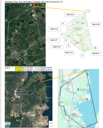
I think that it's an amazing coincidence that the entire town of Westford, MA is exactly 69.09 miles directly above the Rhode Island town of North Kingstown.
My first post shows a map overlay of Westford (black lines) onto North Kingstown.
They are exactly 1 arc degree of Latitude apart. 69.09 statute miles
That's incredible considering the boundaries were made 150+ years ago.
I'll post something on that too
Mark Wright
Jr. Member
- Thread starter
- #9
I do not support anything being anywhere. In 2022 I was accused of just drawing lines. I've attached one complaint I' received from a critic.
I see patterns, do the math, all the scientific method stuff.
I have no idea where it leads until I get there.
I am completely surprised where the path goes.
I see patterns, do the math, all the scientific method stuff.
I have no idea where it leads until I get there.
I am completely surprised where the path goes.
Attachments
Mark Wright
Jr. Member
- Thread starter
- #10
There are 3 legs to this solution.
I gave the first one above
I'll do most of this one for you.
IT REQUIRES the use of the Narragansett Rune Stone
44.512504531084296, -64.28523106528966
43.831199010037224, -66.14978286390084
41.648333180744494, -71.40800087885681
41.614886464378074, -71.48713365668105
42.614886464378074, -71.48713365668105
Mark Wright
Jr. Member
- Thread starter
- #11
treasure1822
Hero Member
- Dec 9, 2010
- 543
- 242
I will give you one to think about...The Shugborough monument in Staffordshire England has the letters carved into it.
O.U.O.S.V.A.V.V
D. M.
(0=15)+(U=21)+(O=15)+(S=19)=70 (V=22)+(A=1)+(V=22)+(V=22)=67 (70 to 67 Longitude) and the is West Longitude
(D=4) (M=13 or (1+3=4) 44 Latitude North
Puts you off the west end of Nova Scotia, By the Overton Stone...
O.U.O.S.V.A.V.V
D. M.
(0=15)+(U=21)+(O=15)+(S=19)=70 (V=22)+(A=1)+(V=22)+(V=22)=67 (70 to 67 Longitude) and the is West Longitude
(D=4) (M=13 or (1+3=4) 44 Latitude North
Puts you off the west end of Nova Scotia, By the Overton Stone...
Mark Wright
Jr. Member
- Thread starter
- #13
Excellent! I'm aware of the shepherd's monument there. I use the mansion roof for measurements. 52.80000941257228, -2.012835755832281I will give you one to think about...The Shugborough monument in Staffordshire England has the letters carved into it.
O.U.O.S.V.A.V.V
D. M.
(0=15)+(U=21)+(O=15)+(S=19)=70 (V=22)+(A=1)+(V=22)+(V=22)=67 (70 to 67 Longitude) and the is West Longitude
(D=4) (M=13 or (1+3=4) 44 Latitude North
Puts you off the west end of Nova Scotia, By the Overton Stone...
I'm working on connecting it to the Kensington Rune Stone.
45.81111613519725, -95.66077731355695
Currently the best route is through Nova Scotia - 4354.92 miles
The closest I get is 2737 ft short of the Kensington parking lot.
I am unfamiliar of your Lat/Long system, but it appears to be the Spirit Pond rune stones, Phippsburg, Maine; 43.74823216691847, -69.80897328069999
Mark Wright
Jr. Member
- Thread starter
- #14
People argue over the meaning of the lettersExcellent! I'm aware of the shepherd's monument there. I use the mansion roof for measurements. 52.80000941257228, -2.012835755832281
I'm working on connecting it to the Kensington Rune Stone.
45.81111613519725, -95.66077731355695
Currently the best route is through Nova Scotia - 4354.92 miles
The closest I get is 2737 ft short of the Kensington parking lot.
I am unfamiliar of your Lat/Long system, but it appears to be the Spirit Pond rune stones, Phippsburg, Maine; 43.74823216691847, -69.80897328069999
Charlie P. (NY)
Gold Member
- Feb 3, 2006
- 13,018
- 17,171
- Detector(s) used
- Minelab Musketeer Advantage Pro w/8" & 10" DD coils/Fisher F75se(Upgraded to LTD2) w/11" DD, 6.5" concentric & 9.5" NEL Sharpshooter DD coils/Sunray FX-1 Probe & F-Point/Black Widows/Rattler headphone
- Primary Interest:
- Metal Detecting
When I see the glitter of treasure I will agree. Until then . . . just another pipe dream of exact measurements to an imaginary goal. Thank you for adding to a rich history of wasted effort.
Mark Wright
Jr. Member
- Thread starter
- #16
Thank you for your comments. You've been on this site for 18 years and you've seen it all.When I see the glitter of treasure I will agree. Until then . . . just another pipe dream of exact measurements to an imaginary goal. Thank you for adding to a rich history of wasted effort.
For what it's worth, I'm not interested in the treasure at all. You may be laughing at that statement but it's true. I'm old, severely disabled, live comfortably on my retirement and in a great country. What more do I need?
I'm interested the hunt. I wish that someone like you, with almost 2 decades of experience, could help rookies like me through the maze. Imagine how many people you could significantly help.
I know where this trail ends to within 5 feet. I haven't told the owner yet because I would like for people on this website to participate. Maybe I've made a mistake. I'd hate to tell the owner what I know and for me to me wrong.
I'm not worried that people will charge onto the property and dig it up. It would be fun to watch them try.
If you can spare the time, why don't you enter some of the coordinates and see where they lead you. You might find that you enjoy being on this side of the game.
treasure1822
Hero Member
- Dec 9, 2010
- 543
- 242
The system is one of the oldest forms of coding...a numerical system based on the alphabet. Replace the letter with its corresponding number then take it to it basic number 0 thru 9. Latitude is easy to calculate. Longitude was not as exact so sailor would sail hitting the Latitude first then sail into their Longitude. They gave a range 70 to 67 degrees. We read left to right so on a chart
This is probably the most basic of coding and it is not number to letter but rather the opposite. Those letters give a Latitude and longitude based on the prime meridian. Locations being an approximate nothing finite about the numbers. Remember the Monument had the Shepherds pointing to the carvings in stone. These will be the what is sought after. Overton stone has a circle with a templar cross in it, The native American depiction of the earth is the circle with a cross in it. This carving also has 4 points on it and the are at the cardinal directions. The Eagle feathers and tobacco leaves are at the north east section of the carving. The feathers and leaves are a "Gift from the gods". The crescent moon is a time duration of 3 to 4 days being that there are 8 quarters to the lunar cycle. It just so happens that the second peninsulas is within that time frame at it also references a gift from the Norse god Odin. These stones are markers for great deeds and the legend of Sigurd. The problem is that within the body of Fafner the Runes do not specify the great deed that was done. But in the legend Fafnir was the guardian of a great treasure that was a gift from Odin. On the slaying of Fafnir Regin, Fafnir's brother told Sigurd to eat Fafnir's heart. When Sigurd had done that he was able to understand the language of the Birds. There is another legend that the language of the birds or the language of the angles were given and that was to Enoch. This language is also called the "Green Language". Referencing the "Green Man" carvings of Roslyn Chapel. When viewing the stone one also has view of Mahone Bay.Excellent! I'm aware of the shepherd's monument there. I use the mansion roof for measurements. 52.80000941257228, -2.012835755832281
I'm working on connecting it to the Kensington Rune Stone.
45.81111613519725, -95.66077731355695
Currently the best route is through Nova Scotia - 4354.92 miles
The closest I get is 2737 ft short of the Kensington parking lot.
I am unfamiliar of your Lat/Long system, but it appears to be the Spirit Pond rune stones, Phippsburg, Maine; 43.74823216691847, -69.80897328069999
Mark Wright
Jr. Member
- Thread starter
- #18
Thank you for the explanation. I'd read about the number system on the Spirit stones. The document was written in paragraph form, and I couldn't keep track of the numbers. Seeing your example first, followed by the explanation really helped.The system is one of the oldest forms of coding...a numerical system based on the alphabet. Replace the letter with its corresponding number then take it to it basic number 0 thru 9. Latitude is easy to calculate. Longitude was not as exact so sailor would sail hitting the Latitude first then sail into their Longitude. They gave a range 70 to 67 degrees. We read left to right so on a chart
This is probably the most basic of coding and it is not number to letter but rather the opposite. Those letters give a Latitude and longitude based on the prime meridian. Locations being an approximate nothing finite about the numbers. Remember the Monument had the Shepherds pointing to the carvings in stone. These will be the what is sought after. Overton stone has a circle with a templar cross in it, The native American depiction of the earth is the circle with a cross in it. This carving also has 4 points on it and the are at the cardinal directions. The Eagle feathers and tobacco leaves are at the north east section of the carving. The feathers and leaves are a "Gift from the gods". The crescent moon is a time duration of 3 to 4 days being that there are 8 quarters to the lunar cycle. It just so happens that the second peninsulas is within that time frame at it also references a gift from the Norse god Odin. These stones are markers for great deeds and the legend of Sigurd. The problem is that within the body of Fafner the Runes do not specify the great deed that was done. But in the legend Fafnir was the guardian of a great treasure that was a gift from Odin. On the slaying of Fafnir Regin, Fafnir's brother told Sigurd to eat Fafnir's heart. When Sigurd had done that he was able to understand the language of the Birds. There is another legend that the language of the birds or the language of the angles were given and that was to Enoch. This language is also called the "Green Language". Referencing the "Green Man" carvings of Roslyn Chapel. When viewing the stone one also has view of Mahone Bay.
treasure1822
Hero Member
- Dec 9, 2010
- 543
- 242
Is it truly a waste if one finds the possibility of explanation in his work? The true waste is the one who never tries...When I see the glitter of treasure I will agree. Until then . . . just another pipe dream of exact measurements to an imaginary goal. Thank you for adding to a rich history of wasted effort.
Mark Wright
Jr. Member
- Thread starter
- #20
Top Member Reactions
-
 2953
2953 -
 2038
2038 -
 1602
1602 -
 1580
1580 -
 1176
1176 -
 1094
1094 -
 1051
1051 -
 1010
1010 -
 910
910 -
 860
860 -
 706
706 -
 684
684 -
 539
539 -
 537
537 -
 400
400 -
 398
398 -
 393
393 -
E
380
-
 370
370 -
 294
294
Users who are viewing this thread
Total: 2 (members: 0, guests: 2)


