Oak Island Artifacts: Just the Facts

All Righty, lets take this one at a time. You say that the people of that area would have know if it was Oak or African Pearwood. So what would they have thought if the wood they were viewing was 25% denser and 16% heavier then Red Oak? Here is the source if you question it....
Pearwood (African) Lumber for Woodworkers - Friendly Service & Fast Shipping from Woodworkers Source

Comments: Sometimes called African Pear, though the wood bears little botanical relation to true Pear (Pyrus genus). Moabi is a very large African tree, frequently yielding figured lumber and veneer; not too unlike Makore. information from this site
Moabi | The Wood Database - Lumber Identification (Hardwoods)

here is a picture of a "African Pearwood"
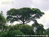
images


Okay, as for the second part....How many people would it take on a 140 acre Island to be considered populated enough to travel to one of the three university and enlist the help of one of their professors...Or would it have been even worth it seeing how it was such a small amount of trees.

Okay now, lets look at the third party. I think you need to add some more information on that. Too many variable to compare the Black Locust to the "Pearwood". As for the tree surviving the Atlantic cold, the only thing I can say is it adapted or went dormant for the cold weather,

Last but not least....Dismissing and Disrespecting, I wasn't talking about the Mi'kmaq.....I am refering to the Overton Stone and the Norumbega Vinland Stone, The "G" staone and the stone trialgle, the white granite stones with the 1/4" holes in them.....I about lost my mind when that "Expert" from "Curse of Oak Island" said the "Overton Carving" was a "Treaty" with the Portuguese. The "First Nation" believed in your words not a "Stone Carving" What people fail to realize is that stone carving is the first "Shepherd of Arcadia". Look at the "Shepherd of Arcadia" monument at Shugsborough Hall in the UK. What are the Shepherds of Arcadia? The answer is quite simple, they are what the shepherds are pointing to...."Stone Carvings". And what do the shepherds protect, " I! Tego arcana dei," God's secrets. So what does the first stone say? The circle with a cross in it is a First Nations symbol for the "Earth" and the 4 directions of the wind. But seeing the Templar cross in it signifies a Templars journey, northeast lies gifts from the gods. But how far, the waning mood which happens every 3 to 4 day....Think about it the Overton stone shows gifts from the gods of the First Nation, The second stone shows gift from the Norse god Odin. What gifts did God give man.....The DM code on the bottom of the Shepherds monument is the longitude and latitude of the west cost of Nova Scotia.
 

As for the Ethnic cleansing of the Arcadiens, it's all good. Those Creole people add a lot to Louisiana....
 

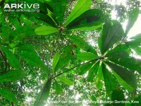
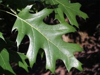
Instead of comparing the differences between the properties of oak versus moabi woods, I'm sure they would have used a more apparent method of identifying the trees; their leaves.
Moabi-leaves-underside.jpg
Moabi has a palmately compound leaf which would be confused with a horse chestnut if it was confused with anything at all.
OAK_RED2_leaves.jpg
Red oak leaves; simple, pinately lobed.
Again, I can't see how these people would have called these trees oak.

How many people would it take on a 140 acre Island to be considered populated enough to travel to one of the three university and enlist the help of one of their professors...
At the time, the area around Mahone Bay, Chester, Chester Basin, Lunenburg was some of the more densely populated areas of the province. The shipbuilding and fishing industries in this area brought people in from away, and sent locals to many other parts of the world. It wasn't as isolated an area as you might think. Halifax is not that far off at all.

Regarding the stones ... well, you have an interesting theory, but there is nothing in there that even remotely resembles a fact. Why is it so unreasonable that the Overton Stone is a Portuguese creation? While the FN in the area were pre-literate and may have taken people at their word, that didn't apply to the Portuguese... and we KNOW that the Portuguese were in this area. We do not know that the Templars, Norse, etc were in the area.
northeast lies gifts from the gods. But how far, the waning mood which happens every 3 to 4 day....
A 3-4 day sail northeast from Overton takes you nowhere near Oak Island.
Think about it the Overton stone shows gifts from the gods of the First Nation, The second stone shows gift from the Norse god Odin.
The Templars ... a Christian order ... referring to gifts from FN or Norse gods?
 

Okay, we are way off track with this whole "Island Name" thing. From here on out it's Island #28. So Island #28 had a undermined cluster of tree's that neither Nova Scotia nor the other 300 islands in Mahone bay had. That is FACT!
The carbon dating on the coconut fiber was dated to 1260 to 1400 AD. This is FACT! Okay, now out of all the possible "Who done it's", which one fits the carbon dating? Sir Henry Sinclair.....Prime suspect!

As for the Portuguese creating the"Overton Stone", I need more like what the whole carving means. Just to say that the Stone was a "treaty" because it had a "Cross" that kind of resembled a cross that the "Knights of Christ" displayed and the Tobacco leave and Eagle Feather were considered to be a gift from the God. That is pretty vague you think.....
Granted, the area had a population of Portuguese but that was in the late 16th century to mid 17th century. If we are to examine the "Cross" closer we find that actually find that it is not "Symmetrical" as represented by the "Knights of Christ". It actually off set like the Knights Hospitaller.

Now, who told you to get back on the ship after you view the "Overton Stone"? Start walking mister, you have a 3 to 4 day walk Northeast following the shore line. Find the second Shepherd.

As for Templar's....they were an "Enochian" Order and to this day are still present but under the Vail of secrecy. The Templar's modeled their beliefs on "Right Hand of God", Enoch....Enoch was favored by God and was taken to heaven without experiencing death. He was also given the ability to speak the language of the bird or also know as the language of the Angels. The Norumbega Stone is a depiction of Sigurd battling Fafnir, the dragon and guardian of a golden treasure. After Sigurd defeated Fafnir, he had roasted Fafnir heart on command of his half brother Regin. Sigurd had tasted the blood of Fafnir and all of a sudden understood what the birds were saying and they warned him of Regins treachery. The stone itself just represents a great deed done somewhere in Mahone Bay. So why Gifts from the Gods....The Mi'kmaq had "Glooscap", The Norse had Odin, Templar's had Enoch. Sir Henry Sinclair was believed to be "Glooscap", He was of Norse descent....His voyage to the New World was coined in the Odal Rights and the Feudal Wrongs; A memorial to Orkney where it is said that him and his men were "Retracing the steps of his ancestors the Vikings. Last but not least, he was a Templar and bound by oath not only to his brethren but to God. He had traveled to the edge of the world, and there was shown a great abyss, where the fallen angels dwelled.
 

So Island #28 had a undermined cluster of tree's that neither Nova Scotia nor the other 300 islands in Mahone bay had. That is FACT!

If it is a FACT then there would be verifiable, concrete evidence indicating so. There is not.

As for the Portuguese creating the"Overton Stone", I need more like what the whole carving means. Just to say that the Stone was a "treaty" because it had a "Cross" that kind of resembled a cross that the "Knights of Christ" displayed and the Tobacco leave and Eagle Feather were considered to be a gift from the God. That is pretty vague you think.....
Granted, the area had a population of Portuguese but that was in the late 16th century to mid 17th century. If we are to examine the "Cross" closer we find that actually find that it is not "Symmetrical" as represented by the "Knights of Christ". It actually off set like the Knights Hospitaller.

Vague, yes, but that seems to be the theme when discussing this sort of thing. All kinds of vague notions being chased with no real, actual facts to support anything. However, jumping feet first into the idea that it HAS to be a Templar carving, when there is absolutely no reason to suspect Templars ... and to completely overlook the FACT that there were Portuguese in the area (Joao Alvares Fagundes was in the area in 1520, by the way) is poor scholarship.

Now, who told you to get back on the ship after you view the "Overton Stone"? Start walking mister, you have a 3 to 4 day walk Northeast following the shore line. Find the second Shepherd.

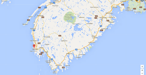
I have a few issues with this. First, I'd have to accept that these theorized people would just abandon their ships to spend days walking along a rough, rocky shore instead of staying in their ships and sailing. Secondly, if they did walk, there is no way they are making it to Oak Island in 3-4 days. Thirdly, if they head NE from Overton, they are nowhere near Oak Island. Take a look at the map:
Overton.png
You can't sail NE from Overton, and if you walk 3-4 days NE from Overton, you end up in the middle of the woods, probably somewhere west or south of Keji.

they were an "Enochian" Order and to this day are still present but under the Vail of secrecy.

Not so secret if you know about it. Odds are that, because of their relationship with St. Bernard, their beliefs were more in line with the Cistercians.

The Templar's modeled their beliefs on "Right Hand of God", Enoch....

Must be cramped at God's right hand. Is Enoch sitting on Christ's lap? The essential tenets of the Christian faith are laid out in the Apostles and Nicene Creeds. Since 381 AD - the first council of Constantinople - Christ has, apparently, been the Right Hand of God.

The Norumbega Stone is a depiction of Sigurd battling Fafnir...

The Norumbega Stone is widely regarded to be a modern carving.

Sir Henry Sinclair was believed to be "Glooscap"...

*facepalm*
Glooscap is the creator god for the people of the Wabanaki Confederacy - the Mi'kmaq, Malliseet, Passamaquoddy, Penobscot, and Abenaki - who occupied a territory that now encompasses Nova Scotia, New Brunswick, PEI, the Gaspe region of Quebec, parts of the St Lawrence valley, in addition to Maine, New Hampshire, Vermont and Massachusetts. Do you really expect people to believe that Sinclair was such an amazing person who accomplished such awesome feats that not only did the local Mi'kmaq throw away their previous theology to accept him as their creator god, but they manage to convince the rest of the Confederacy to do so as well? ... and over a wide geographic area and short period of time? To believe that Glooscap is Sinclair would be to throw away all the stories that the Mi'kmaq have built around him... disregard their entire faith system.

His voyage to the New World ...

His ALLEGED voyage to the New World.... there is no evidence of this voyage.

Last but not least, he was a Templar ...

... except there is nothing to suggest that he was ...
 

If it is a FACT then there would be verifiable, concrete evidence indicating so. There is not.


Vague, yes, but that seems to be the theme when discussing this sort of thing. All kinds of vague notions being chased with no real, actual facts to support anything. However, jumping feet first into the idea that it HAS to be a Templar carving, when there is absolutely no reason to suspect Templars ... and to completely overlook the FACT that there were Portuguese in the area (Joao Alvares Fagundes was in the area in 1520, by the way) is poor scholarship.


I have a few issues with this. First, I'd have to accept that these theorized people would just abandon their ships to spend days walking along a rough, rocky shore instead of staying in their ships and sailing. Secondly, if they did walk, there is no way they are making it to Oak Island in 3-4 days. Thirdly, if they head NE from Overton, they are nowhere near Oak Island. Take a look at the map:
View attachment 1323065
You can't sail NE from Overton, and if you walk 3-4 days NE from Overton, you end up in the middle of the woods, probably somewhere west or south of Keji.


Not so secret if you know about it. Odds are that, because of their relationship with St. Bernard, their beliefs were more in line with the Cistercians.


Must be cramped at God's right hand. Is Enoch sitting on Christ's lap? The essential tenets of the Christian faith are laid out in the Apostles and Nicene Creeds. Since 381 AD - the first council of Constantinople - Christ has, apparently, been the Right Hand of God.


The Norumbega Stone is widely regarded to be a modern carving.


*facepalm*
Glooscap is the creator god for the people of the Wabanaki Confederacy - the Mi'kmaq, Malliseet, Passamaquoddy, Penobscot, and Abenaki - who occupied a territory that now encompasses Nova Scotia, New Brunswick, PEI, the Gaspe region of Quebec, parts of the St Lawrence valley, in addition to Maine, New Hampshire, Vermont and Massachusetts. Do you really expect people to believe that Sinclair was such an amazing person who accomplished such awesome feats that not only did the local Mi'kmaq throw away their previous theology to accept him as their creator god, but they manage to convince the rest of the Confederacy to do so as well? ... and over a wide geographic area and short period of time? To believe that Glooscap is Sinclair would be to throw away all the stories that the Mi'kmaq have built around him... disregard their entire faith system.


His ALLEGED voyage to the New World.... there is no evidence of this voyage.


... except there is nothing to suggest that he was ...

In the immortal words of Ralph Kramden..."Your Killing me Alice!"....

You looked at the picture of Smith Cove with the "Unique Tree's". My Question... Where are those tree's on the main land or the other island....Simple...

As for the "Portuguese in the area" is not new news to me. The "Expert" on "Curse of Oak Island" said it was the "Knights of Christ" because of the "Cross" in the stone carving.....I am saying it is "Hospitaller". You just said it's not "Templar" but no reason why.....

The 3 to 4 day's common..... Strike a straight line from Overton to the Second Peninsula on the south end of Mahone Bay. Gee, about 100 mile....A person walk's at a adverage speed of 3.0 miles per hour. Roughly 8 hours a day factoring in eating and resting. About 24 to 25 miles a day...Equals 4 days or less if they walked longer per day or faster.

Yes, some people do think it's a modern carving....Produce the "Artist"....That shouldn't be hard, an artist who put that kind of time into it would not have done it for nothing....And I would have expected a better attempt at creating a reproduction by an artist. BY the way, how deep is was carving on that stone and what is the rate of erosion? You see the expert they had sent the pictures to and yes, that's how he had made his judgement, by pictures, and by the idea that Viking's never came this far into the new world.

The "Secret Society" I was referring to is the "Freemason"....

Have you ever looked into the stories of Glooscap"....Here is an exert fro "These Stones Bear Witness"..."Glooscap is described as having fair skin and blue eye's. He carries a sword of sharpness, and he sailed from his island home in the East on "a floating island".page 84...

Prove to all that believe in his voyage, it did happen.....show me his grave with proof of his remains.....Tell me why his son, never took the position of Earl of Orkney until 12 years after Henry's so called death? What was he waiting for, the dead to arise again.
 

Where are those tree's on the main land or the other island....Simple...

Simple. Tell me what species of tree they are, and whether the unique shape is natural to that species or whether it's the result of krumholtz.


You just said it's not "Templar" but no reason why.....

Actually, I didn't say that. What I was getting at was that there is no evidence that it is Templar, and that claiming it is without evidence is trying to twist the 'proof' to suit your conclusions.


The 3 to 4 day's common..... Strike a straight line from Overton to the Second Peninsula on the south end of Mahone Bay. Gee, about 100 mile....A person walk's at a adverage speed of 3.0 miles per hour. Roughly 8 hours a day factoring in eating and resting. About 24 to 25 miles a day...Equals 4 days or less if they walked longer per day or faster.

I'm a forester. I spend weeks at a time slogging through the woods, most of the time in the area that we're talking about here ... between Yarmouth and Chester. First off, following Highway 103, which roughly follows the coast, it's 150 miles from Overton to Oak Island. Secondly, you stated that they would be following instructions which told them to go NW from the Overton stone. Oak island is not NW of Overton. Thirdly, even if it were 100 miles, there is no way they are making it in 3-4 days. Off the top of my head, there are six large rivers between Overton and Chester that they would have to find some way to cross. Not to mention the swamps. Hell, most of Shelburne County is swamp. Slogging through, or diverting around, would take a lot of time. Fourth, if they were to have taken a straight bearing from Overton to the Second Peninsula, how would they keep a true bearing? Even if they did have a compass, how precise would it have been? If it were out by even one degree, over 100 miles, they'd never find where they were supposed to be.


That shouldn't be hard, an artist who put that kind of time into it would not have done it for nothing....

... unless his reward was seeing all the fantastic theories that evolved from his hoax. Like the man says: "some people just want to watch the world burn".


"..."Glooscap is described as having fair skin and blue eye's. He carries a sword of sharpness, and he sailed from his island home in the East on "a floating island".page 84...

He was also credited with creating Prince Edward Island and the Annapolis Valley, which would be a surprise to the people who were living there for millennia prior to Sinclair's alleged visit. It should also be noted that Glooscap's home is on Cape Blomidon on the Minas Basin, not Oak Island, not New Ross, not Annapolis Royal.


Prove to all that believe in his voyage, it did happen.....show me his grave with proof of his remains.....Tell me why his son, never took the position of Earl of Orkney until 12 years after Henry's so called death? What was he waiting for, the dead to arise again.

That isn't how it works. You can't prove a negative. It is up to you to prove that he did make this voyage, not for anyone to prove he didn't.
 

Simple. Tell me what species of tree they are, and whether the unique shape is natural to that species or whether it's the result of krumholtz.


Actually, I didn't say that. What I was getting at was that there is no evidence that it is Templar, and that claiming it is without evidence is trying to twist the 'proof' to suit your conclusions.


I'm a forester. I spend weeks at a time slogging through the woods, most of the time in the area that we're talking about here ... between Yarmouth and Chester. First off, following Highway 103, which roughly follows the coast, it's 150 miles from Overton to Oak Island. Secondly, you stated that they would be following instructions which told them to go NW from the Overton stone. Oak island is not NW of Overton. Thirdly, even if it were 100 miles, there is no way they are making it in 3-4 days. Off the top of my head, there are six large rivers between Overton and Chester that they would have to find some way to cross. Not to mention the swamps. Hell, most of Shelburne County is swamp. Slogging through, or diverting around, would take a lot of time. Fourth, if they were to have taken a straight bearing from Overton to the Second Peninsula, how would they keep a true bearing? Even if they did have a compass, how precise would it have been? If it were out by even one degree, over 100 miles, they'd never find where they were supposed to be.


... unless his reward was seeing all the fantastic theories that evolved from his hoax. Like the man says: "some people just want to watch the world burn".


He was also credited with creating Prince Edward Island and the Annapolis Valley, which would be a surprise to the people who were living there for millennia prior to Sinclair's alleged visit. It should also be noted that Glooscap's home is on Cape Blomidon on the Minas Basin, not Oak Island, not New Ross, not Annapolis Royal.


That isn't how it works. You can't prove a negative. It is up to you to prove that he did make this voyage, not for anyone to prove he didn't.

LOL! Your the "Forestry Personel", who claimed that those tree's were not "African Oaks" and not "Pearwood Trees". My point is that they were "Unique or non indigenous" to the area. You won't even take a guess based on the size and shape of the tree.

So you are saying it might or might not be a "Templar cross" but because there were Portuguese there It has to because of them? That really doesn't make any sense.....

Ummm no, I said Northeast from Overton. You see if they had given a time span that means they had to of either made it in that time or they had created a way to get there in that time. You are basing your answers by today's standards, What was the terrain like in 1400? And I don't believe that they were that stupid....They managed to travel great distances without the aid of a compass.

"Some people just want to watch the world burn".....So your saying some guy for laughs, created a Rune stone depicting the legend of "Sirgurd" and the just to mess with peoples mind he added the "Christian Cross" to the back of a Nordic legend. I don't know about that....The Nordic people had adopted Christianity but did not mix the two. I would suggest looking into the legend of "Sigurd" shares a commonality with the Story of Enoch and the rights to becoming a Freemason.

The legends of "Glooscap" I am sure was well before the arrival of Sir Henry Sinclair and the Templar's. But here's a theory and tell me if it is possible. Seeing how the Mi'kmaq people were not as well traveled as other people of the "World". Could Sir Henry or any one else of the group be thought of as a "Deity", big boat thought of as a island...Teaching the game of Shinty to the Mi'kmaq which is now lacrosse. Teaching the Mi'kmaq to fish with nets. Weapons made of steel while the Mi'kmaq still used wood and stone tools and weapons. Gee, one of the friends of "Glooscap" even had facial hair....Not a trait in the people of the First nation. I'm just wondering, is it possible.....

"You can't prove a negative"....Is that some "Canadian" thing? I am saying that "Europeans" were there during that time and you are saying no. If you are looking for hard "Tangible" proof....all I can say is remember the key theme behind their venture was "SECRECY"...
 

My point is that they were "Unique or non indigenous" to the area. You won't even take a guess based on the size and shape of the tree.

Your first claim was that they were African oak ... then some pearwood ... then non-native ... now it's just unique. What is your guess going to be tomorrow? That's why I'm not going to guess. It makes a person look silly. I don't know what they are but, as I have mentioned before, there is no way that a non-native tree growing that vigorously for hundreds of years on Oak Island would not spread to the mainland.


So you are saying it might or might not be a "Templar cross" but because there were Portuguese there It has to because of them? That really doesn't make any sense.....

I am saying that there is no evidence that it is Templar. There is a cross carved into a rock that looks similar to what the Portuguese were known for. We know that the Portuguese were in the area in the 1500's. Occam's razor says that if this carving is anything, odds are it's Portuguese, if not something more modern.


Ummm no, I said Northeast from Overton.

You're right. You did say NE. I mis-typed. My statement still stands, though. Travelling NE from Overton will take you nowhere near Oak Island.


You are basing your answers by today's standards, What was the terrain like in 1400?

The terrain 600+ years ago was the same as it is today. The rivers, swamps, lakes, rock fields, and bogs that are there now didn't just show up in the past few centuries.


They managed to travel great distances without the aid of a compass.

How? Travelling more than a hundred miles, over rough terrain, around lakes and swamps, over rivers ... and able to hit their mark? That's an impressive feat even with a compass. How exactly were they able to navigate so effectively and with such precision without a compass? ... and in 3-4 days, too...


So your saying some guy for laughs, created a Rune stone depicting the legend of "Sirgurd"

I'm saying that it's more likely that some guy was bored, and tried to copy a Scandinavian carving.


...just to mess with peoples mind he added the "Christian Cross" to the back of a Nordic legend.

...assuming it was the same carver.


Could Sir Henry or any one else of the group be thought of as a "Deity", big boat thought of as a island...Teaching the game of Shinty to the Mi'kmaq which is now lacrosse. Teaching the Mi'kmaq to fish with nets. Weapons made of steel while the Mi'kmaq still used wood and stone tools and weapons. Gee, one of the friends of "Glooscap" even had facial hair....Not a trait in the people of the First nation.

The island that Glooscap is said to have come from is Newfoundland. Lacrosse was originated by the Algonquians in the Great Lakes region, not by the Mi'kmaq ... or did Sinclair visit there, too. Mi'kmaq have been fishing with nets for millennia. First Nations can also grow facial hair, just not as thick as other ethnicities. Is it possible that you are, once again, trying to mangle things to suit your pet theory?


I am saying that "Europeans" were there during that time and you are saying no. If you are looking for hard "Tangible" proof....all I can say is remember the key theme behind their venture was "SECRECY"...

I am saying that there is no evidence to suggest that there were Europeans in Nova Scotia at that time. To suggest that there is no evidence of them being there because of the secrecy of their mission, and suggesting that this lack of evidence is actually evidence is beyond foolish.
 

Your first claim was that they were African oak ... then some pearwood ... then non-native ... now it's just unique. What is your guess going to be tomorrow? That's why I'm not going to guess. It makes a person look silly. I don't know what they are but, as I have mentioned before, there is no way that a non-native tree growing that vigorously for hundreds of years on Oak Island would not spread to the mainland.


I am saying that there is no evidence that it is Templar. There is a cross carved into a rock that looks similar to what the Portuguese were known for. We know that the Portuguese were in the area in the 1500's. Occam's razor says that if this carving is anything, odds are it's Portuguese, if not something more modern.


You're right. You did say NE. I mis-typed. My statement still stands, though. Travelling NE from Overton will take you nowhere near Oak Island.


The terrain 600+ years ago was the same as it is today. The rivers, swamps, lakes, rock fields, and bogs that are there now didn't just show up in the past few centuries.


How? Travelling more than a hundred miles, over rough terrain, around lakes and swamps, over rivers ... and able to hit their mark? That's an impressive feat even with a compass. How exactly were they able to navigate so effectively and with such precision without a compass? ... and in 3-4 days, too...


I'm saying that it's more likely that some guy was bored, and tried to copy a Scandinavian carving.


...assuming it was the same carver.


The island that Glooscap is said to have come from is Newfoundland. Lacrosse was originated by the Algonquians in the Great Lakes region, not by the Mi'kmaq ... or did Sinclair visit there, too. Mi'kmaq have been fishing with nets for millennia. First Nations can also grow facial hair, just not as thick as other ethnicities. Is it possible that you are, once again, trying to mangle things to suit your pet theory?


I am saying that there is no evidence to suggest that there were Europeans in Nova Scotia at that time. To suggest that there is no evidence of them being there because of the secrecy of their mission, and suggesting that this lack of evidence is actually evidence is beyond foolish.

Man, you do not pay attention.....My only belief was that the tree was a "Pearwood", and you went off on "People were smart enough to know the difference between the kinds of tree". Well if they were able to determine what kind of tree they were why did they call them "Oaks"? And are you saying that "Pearwood" is indigenous to the area? I never claimed they were African Oaks, that was written in that passage I copied. And two, there were 3 or 4 trees in that picture, you call that "Vigorous".

You keep saying the "Portuguese" carved that cross, but what "Portuguese"? What the expert in the "Curse of Oak Island" season 3 episode 4 said was "Portuguese Templar's"....You keep saying "Portuguese", are you suggesting "Joe Average Portuguese Immigrant" just randomly decided to create such a piece just to see how people would react?....Seems to be a lot of that there in Nova Scotia.....You claimed that there are a lot more population then I give Nova Scotia credit for and that any non indigenous tree specie would have been noted and written about but yet it seems no one could hear a hammer and chisel on a boulder....

And again....your being selective on what you read....I never said it would take you to "Oak Island"....I said to the north shore of the second peninsula on the southern end of Mahone Bay. And yes it will take you there...And by the way, the dry compass was being used in medieval Europe as early as 1300 AD so it was available during that time.

So, your telling me that you have walked pretty much a straight line from Overton to the second Peninsula and it is virtually impassible....so my only question would be, "How long did it take you?"

You have it in your mind that the people back then were stupid....How did they ever find Jerusalem during the first crusades, they didn't even have a compass..

You might want to recheck your dates on the whole "Field Hockey", The Algonquin's were noted playing it in the late 1700's but the origin's is based on Northeast region of North America in Canada....

And I am saying that to ignore the legends of the First Nation is beyond ignorant because you close yourself out to possibly the only evidence that they were here. You tell me how did the "White Man" get into the Mi'kmaq legends if he was never here! They didn't lie, the spoke of what they had seen....the "Blue Eye's" and "Facial hair" is not in the genetics of any Native North American unless bread in by a European. The only thing that is foolish is a closed mind!
 

Well if they were able to determine what kind of tree they were why did they call them "Oaks"?

Maybe they were oaks.


And are you saying that "Pearwood" is indigenous to the area?

No.


And two, there were 3 or 4 trees in that picture, you call that "Vigorous".

Yes I do. The trees that are shown in that photo appear to be healthy and growing with vigour. There is no reason why they should not be throwing seed.


You keep saying the "Portuguese" carved that cross, but what "Portuguese"?

What I was getting at was, if this is not a modern carving, why assume, without any supporting evidence, that it is a Templar carving and not Portuguese... or even First Nations, for that matter.


I said to the north shore of the second peninsula on the southern end of Mahone Bay. And yes it will take you there...

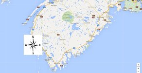
No it won't. I'll attach that map again, this time with a directional arrow superimposed on it at Overton. Taking a NE bearing from Overton will not take you anywhere near Mahone Bay.

Overton.jpg


So, your telling me that you have walked pretty much a straight line from Overton to the second Peninsula and it is virtually impassible....so my only question would be, "How long did it take you?"

No... no I'm not saying that, and I'm kind of baffled that you took that from what I have written. I said that I have worked extensively in the woods in this area. I am familiar with the terrain, and confident that there is no way in Hell that anyone 700 years ago is going to walk from Overton to Mahone Bay while maintaining a constant bearing while crossing rivers and diverting around swamps, bogs and lakes. ...and they're sure as Hell not doing it in 3-4 days.


How did they ever find Jerusalem during the first crusades, they didn't even have a compass..

Just a guess, but maybe they had maps and crew familiar with the area? You think?


You might want to recheck your dates on the whole "Field Hockey", The Algonquin's were noted playing it in the late 1700's but the origin's is based on Northeast region of North America in Canada....

First you talk about Sinclair teaching the Mi'kmaq shinty which evolved into lacrosse, and now you are talking about the Algonquians playing field hockey in the 1700's. Regardless. It began in what is now Ontario.


And I am saying that to ignore the legends of the First Nation is beyond ignorant because you close yourself out to possibly the only evidence that they were here.

Considering the legends associated with Glooscap (creating PEI and NS, turning people to stone, etc...) using them as 'the only evidence that they were here' is pretty sketchy. Cite your sources for these legends, please ... preferably something from a credible source... not some alternative history site.
 

HI Lokie, just what facts can there be? A block & tckle found hanging over what apppeared to be an xcavation. the rest is modern venture.

Good point to ponder.

Seems to me that IF the most publicized money pit legend (that being a hole with a depth of over 200 feet, planks at 10 ft intervals, flood trap mechanism, etc...), is true, there would be still be much physical evidence of the initial construction. The massive effort and number of people required for an endeavor that complex, would most certainly have left its mark. How much that would have been destroyed by the deluge of searchers, would also have to come into play. Still looking for known physical evidence.........
 

Yeah I think Don Jose has nailed it. That's about the total known part of the legend. Couple of boys found a spot, did some digging, found some wood planking, place flooded, boys gave up. Rest is more story than truth. Seems like everyone somewhere along the line might have been involved in this when you hear all the stories associated with it.

And yes, looking at all the destruction done with heavy equipment over the years, I really doubt any landmarks nearby, (if there ever were any) survived, most likely got bulldozed into oblivion.
 

After loosing money to the money pit, all one needs to do is make up a story about gold chain discovered or gold on the tip of there drill bit to secure the sale to the next treasure hunters.
 

You know I just thought of something. Okay, just for S&G's, we'll say a whole bunch of folks show up on the island to bury something. They dig and dig, setting up traps and finalizing the main vault(s). Now, all those folks had to eat, sleep, use the bathroom, etc. Where are all the spots where such occurred?

If this was even a small group, there would be primary spots for campfires, outhouses, dumps, etc. Yet not one mention of such that I can remember anyone mentioning. Heck even if they called for take out, there would be dumps for all the pizza boxes, Chinese containers, McDonald's wrappers they would have to get rid of. Did they carry all their food? If not they had to hunt. If they hunted, there would be butchering of such. Butchering tends to leave bones. Where's the pile of bones from all the animals they would have had to have killed for food. How bout shelter, where's the camps they would have built?

And how bout all that lumber for the platforms. They didn't go to the local Ace Hardware. It came from one of two places. They either carried it with them, most likely taking apart a ship, or they harvested it in the forest. Harvesting would be a whole nother place that would have to be set up to do so. I mean this wasn't done by a couple of Knights with swords. Take apart their ship?
I guess if they knew they weren't going back, but ships used ballast, you can only remove so much wood before the ballast either sinks the remains of the ship, or the ballast drops out. Any remains of a ship(s) out there?

And while at it, where did all the "dirt" from digging the tunnels end up? I mean this wasn't the Great Escape, carrying a little dirt around and dropping it all over the place to hide it. That would have been some big time debris to scatter without anyone noticing it.

All this and no one seemed to see anything unusual in the hood? Man, these folks were good.
 

Last edited:
I'm no expert on the subject but... people in these times were used to carrying food for a lot of people on these ship trips.. Heck, there would be the need for a lot of food and water just to make the trip there. The dirt from the Money Pit is back in the Money Pit. Dig, pile, refill... Same with flood tunnels, etc.. Human waste was probably just dumped in the water as it would be while on the trip there.. if any of this is true..
 

Top Member Reactions

Users who are viewing this thread

Back
Top