Good afternoon ELLE: no, it doesn't appear to be, but then it has been a few years. he he .
You posted -->
"Do you mind if we hook up and try to go locate that large bell in the river bed sand? I'll pay for the expedition, but I'll need you to be the guide!"
~~~~~~~~~~~~~~~~
A) That depends upon many things, some are out of my immediate control. On the trip expenses, no problem, I can easily hold up my own. As for directions, I can tell you more or less where to look, but not exactly, no one can today. The original Church was in the present river channel, in front of the present Church. which was supposedly a convent then. Of course it has been enlarged for the present church.
The best time for that, is in late June, a window of perhaps two weeks. The Rio Fuerte wasn't called that without reason. I have seen it 100 ft deep and 3/4 of a mile across. Incidentally, this stretch of the river in front of the Church was where I saw that aquatic serpent, of approx. 80 ft, about 1 meter thick . I never swam across the river nude again.
When I was there, I was looking for the 'SUN' which is on the north side of the river. This played crucial part in proving the existence of the Gloria Pan mine which I eventually found. Long story there.
After the Indian uprising had been subdued, they were constructing a new mission on top of the ridge to the north, between Tubares and Temoris. It was to be named for one of the priests that had been killed in the uprising. The Jesuits kept in Contact by fires at night, and mirrors in the day.
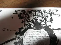
Since they had an altar, which had been brought from Michoacan for the new mission, I assume that they also had a bell, which might be interesting. All of these things are stored in the second level of the Gloria Pan mine. Yes, I have found the site of the new Mission, I believe that I am the only one alive that knows of it and where it is. The cut blocks were 2 ft square.
It is a fascinating area.
Attached is some interesting data for you to play with. all questions will be happily answered, I have nothing to hide.
The bell from my Mine, TAYOPA, lies about one day's journey East from Tayopa. It is in a closed tunnel, but I am going to open it soon. I will let you know when I see it.
Don Jose de La Mancha (Joseph Curry)
P.S. All of my traveling was done by mule and alone. Not like these swabies in here who only believe in booze, broads, & buckets of Reales.
~~~~~~~~~~~~~~~~~~~~~~~~~
http://www.ethnologue.com/show_language.asp?code=tbu
Enrique Chacón explicó que "la misión de los tubares fue construida alrededor de 1700-1701; algo interesante es que después de haber abandonado sus sitios arqueológicos, los indígenas regresaron hacia el año de 1767 con la expulsión de los jesuitas. En El Sauzal, los tubares ocuparon el sitio en la época prehispánica y posprehispánica".
http://www.traveljournals.net/stories/23795.html
http://www.mexicohorse.com/road_log_el_fuerte_to_la_reforma.htm
http://www.panoramio.com/photo/2234054
Quote---"There’s now a paved road all the way from Creel to Divisadero and on to San Rafael. From San Rafael, there’s a new road connecting Bahuichivo, Cerocahui, Mesa de Arturo, Piedras Verdes, Tubares (there’s a new bridge over the Río San Miguel), Choix, and on to El Fuerte. Note that you will need a 4WD between Mesa Arturo and Tubares (about 70km). Or you could go from San Rafael to Álamos via Bahuichivo, Témoris and Chinipas, crossing the Río Chinipas, though this road is very rough and assaults have been reported on it, so travel at your own risk"


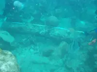
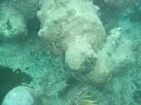
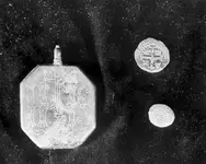
") We have not raised any cannon from this wreck, in fact we try to never raise an iron gun. We do plan to knock the encrustation off of a trunion and try to determine if there are any numbers or markings there. If you do tjhis, you can coat the exposed iron with axle grease and petit the encrustation back onto the gun, causing almost no damage whatsoever. The photos and measurements of the cannon and anchors have been studied, and most of our resources tell us Spanish, mid to late 1600's, so the puzzle fits together nicely. Of course, all of them said it was very hard to be sure and that these were guesses based on a number of factors. This was before we found the bell, so the bell definitely added some credence to their guesses.
We have not raised any cannon from this wreck, in fact we try to never raise an iron gun. We do plan to knock the encrustation off of a trunion and try to determine if there are any numbers or markings there. If you do tjhis, you can coat the exposed iron with axle grease and petit the encrustation back onto the gun, causing almost no damage whatsoever. The photos and measurements of the cannon and anchors have been studied, and most of our resources tell us Spanish, mid to late 1600's, so the puzzle fits together nicely. Of course, all of them said it was very hard to be sure and that these were guesses based on a number of factors. This was before we found the bell, so the bell definitely added some credence to their guesses.