OK, ok
My final say in the matter
")
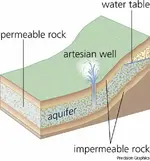
Artesian Well. There must have be a hole in the bottom that is covered up.
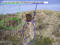
Due to the situation of mountains in NM, I think this theory is the most logical. Also, if you look at the wide view pic of the area, most of the "greenery" is in the area of the rocks and below.
See below to see how it works...
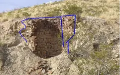
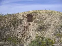
Pix 1 and 2
Artesian Well - deep drilled well through which water is forced upward under pressure. The water in an artesian well flows from an aquifer, which is a layer of very porous rock or sediment, usually sandstone, capable of holding and transmitting large quantities of water. The geologic conditions necessary for an artesian well are an inclined aquifer sandwiched between impervious rock layers above and below that trap water in it. Water enters the exposed edge of the aquifer at a high elevation and percolates downward through interconnected pore spaces. The water held in these spaces is under pressure because of the weight of water in the portion of the aquifer above it. If a well is drilled from the land surface through the overlying impervious layer into the aquifer, this pressure will cause the water to rise in the well. In areas where the slope of the aquifer is great enough, pressure will drive the water above ground level in a spectacular, permanent fountain. Artesian springs can occur in similar fashion where faults or cracks in the overlying impervious layer allow water to flow upward. Water from an artesian well or spring is usually cold and free of organic contaminants, making it desirable for drinking. In North America, the Dakota sandstone provides aquifers for an artesian system that underlies parts of the Dakotas, Montana, Wyoming, Kansas, Nebraska, and Saskatchewan and supplies great quantities of water to the dry Great Plains region. Many East Coast cities derive their water supplies from aquifers that are exposed along the edge of the Piedmont and dip downward toward the Atlantic coast. The largest artesian system in the world underlies nearly all of E and S Australia. Other important artesian systems serve London, Paris, and E Algeria.
--------------------------------------------------------------------------------
Pic 3
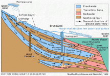
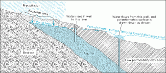
Bottom diagram is Brunswick, GA
Example of an aquifer system with artesian wells
The diagram below shows the aquifer system near Brunswick, Georgia, as it was before development of the Floridan aquifer system in the 1880’s. The aquifer system was under artesian conditions and the pressure in the aquifer system was great enough that wells flowed at land surface throughout most of the coastal area. In some areas, pressure was high enough to elevate water to multi-story buildings without pumping. The artesian water level (potentiometric surface) was about 65 feet above sea level at Brunswick. Ground water discharged naturally to springs, rivers, ponds, wetlands, and other surface-water bodies and to the Atlantic Ocean. Nowadays, ground-water pumping has caused the water level in the aquifer to decline throughout the entire coastal area, with the result that some artesian aquifers no longer have enough pressure to cause a well to naturally flow to the land surface.
I think it must have a shallow water table , because once it got to a certain level in the tank, it probably didn't have enough pressure to "blow" high like a geiser. As long as there was water in it, the tank probably just kept a constant level. This would all make sense as long as water use further down the aquifer didn't use up all of the water that would keep the well at this water level. Once it was used, no more water was avalable and the tank fell apart from erosion caused by the normal rains and weather. After all is is located in a steep area of a hill...gravity worked against it.
If you look at the rocks, you can see where the water level was for the most part (where the minerals leached from the sandstone). The rocks above that level look normal. The funky red looking stuff is probably hardened clay mud. It was probably like the stuff that settles in the bottom of a tub after you give your dog a bath. It was probably soft and gooshy when wet, but hard as a rock when it dries.
Thoose are my last thoughts 
Burt


 z1.webp77.4 KB · Views: 1,254
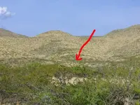 z10.webp55.7 KB · Views: 1,176
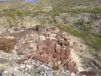 z9.webp90 KB · Views: 1,179
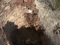 z8.webp73 KB · Views: 1,189
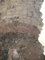 z7.webp90.8 KB · Views: 1,209
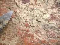 z6.webp70.9 KB · Views: 1,195
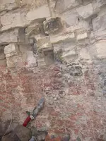 z5.webp105.7 KB · Views: 1,211
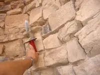 z4.webp45.6 KB · Views: 1,211
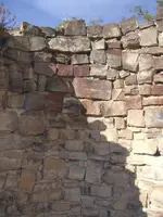 z3.webp76.2 KB · Views: 1,236
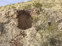 z2.webp99.4 KB · Views: 1,235
 Pretty cool whatever it is !
 i think thats what they r called