need some expertise on a old structure, possible well??? INDIAN??? LOOK

chong2

Bronze Member
Joined
Apr 25, 2006
Messages
2,041
Reaction score
141
Golden Thread
0
Location
El Paso, TX
Detector(s) used
Flippin Stick n good luck :)
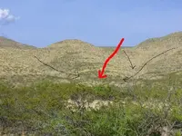
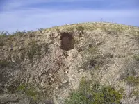
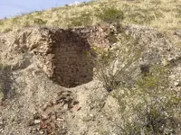
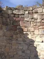
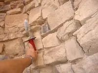
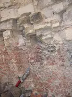
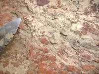
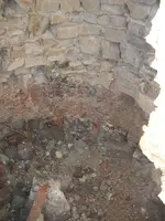
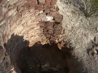
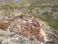
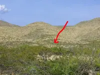
i have been meaning to get some pictures up of this, i found this when i was about 16. now there is another one of these i also stumbled upon when i was younger, about 8 miles away. both located at the base of foothills. both eroded the same way. both located right above a ravine. they were made with natural stone from the area. the " bottom" has a red material, clay? at this particular location i browsed around and found no evidence of a foundation. im wondering what they are, probally a well. why located where they are, at base of foothills, on the hills themselves. who possible made them, ranchers? indians? early explorers? and how old are they? the erosion you can see for yourself. now these are in the desert southwest. not much rain comes by here. lets hear your opinions.
 

Attachments

  • z1.webp
    z1.webp
    77.4 KB · Views: 1,254
  • z2.webp
    z2.webp
    99.4 KB · Views: 1,235
  • z3.webp
    z3.webp
    76.2 KB · Views: 1,236
  • z4.webp
    z4.webp
    45.6 KB · Views: 1,211
  • z5.webp
    z5.webp
    105.7 KB · Views: 1,211
  • z6.webp
    z6.webp
    70.9 KB · Views: 1,195
  • z7.webp
    z7.webp
    90.8 KB · Views: 1,209
  • z8.webp
    z8.webp
    73 KB · Views: 1,189
  • z9.webp
    z9.webp
    90 KB · Views: 1,179
  • z10.webp
    z10.webp
    55.7 KB · Views: 1,176
Wow. What a puzzler. I would suggest, if you have not already, metal detecting the entire site. If that yields nothing try, what an effort, excavating in the bottom. Watch out for cave ins! If that yields nothing you might want to contact a local University or College and ask there. A local museum might be able to shed some light. If it is Native American a few questions to a professor of Indian "culture"? might help. We have burial mounds here in Florida. Once you declare them the State moves in and forbids any one to disturb any thing. Literally. So be prepared to run into that hurdle if you decide to go the route I mentioned. They are fascinating. I have no idea what they are. But if they were kilns,wouldn't there be smoke on the walls? Let us know what you find out. Good luck!
 

Upvote 0
That's a Gold mine or prospect audit. The brick wall is to keep soil from falling into the vertical shaft they where prospecting. I've see a few like that. It's not a well as I see no way for water to shed from the hillside to be captured. The reason a prospector would be interested in such a mundane looking place is what looks like exposed shiest, rusted quarts, and red soils to the left of the audit. All of which are gold indicators.

Just my opinion.
 

Upvote 0
This is a great challenge.

If it's a kilm (lime or otherwise) how was it fueled? You either build a kiln next to the job site or transport hub (i.e. city or railway) or near your source of fuel (wood, coal). I don't see any of any of these things in the images, Nor do I see a limestone quarry (though the rocks are decidedly dressed in the walls). Lime for cement (and fertilizer) is made by baking limestone. This spot is nowhere. No one would build a kiln where all fuel and materials had to be imported and the end products exported. Just no economic or labor sense.

Plugged shaft? Maybe. Look for evidence of a hoisting derrick or frame that would have been in place over the shaft.

Hunting blind? Pretty labor intensive when a bush or shallow hole with a dusty blanket will do.

Cistern? May well be. ;) It looks enough like local dug wells that I would buy that. Don't know that area, but hereabouts when an artesian spring is found you put the well there. They can come and go with seasonal or long term soil changes. Sometimes the infeed is above the bottom of the pit so that as the spring dries up the water is available for a while after. Any broken pots or buckets nearby?
 

Upvote 0
i think the mining idea now is a good one, i just dont see why they would go to so much trouble to. these hills have never produced gold, mica, and marble about 7 miles away. there is gold but way further up the mountain. there is NO way runoff could fill this thing up, no pots or cans, alot of .22 shells scattered. ill see if i can get to the other one i spoke about this weekend, since i am visiting the area, if i do ill take more pics.
one more thing about the springs, they are scattered all over the mountains here.
 

Upvote 0
I have no clue as to the what these are but was watching something on one of the documentary channels about archeology and well sites and other shafts or structures like these and I just wanted to remind you not to only depend on a metal detector. Granted if it were a well you might find metal remnants of a bucket or bucket handle but if it is Native American you might finds clay objects such as a clay pot or ladle or something. I would at least scratch the surface two or three feet down,and very gently. Just a thought. I believe the documentary was about a well site at Jamestown. And if memory serves me correctly they found a pair of glasses, a soapstone pipe bowl,and pottery fragments.
 

Upvote 0
thats a idea, maybe even probe it eh? ya there is tons of mesquite here
 

Upvote 0
Come on guys... It's a simple water well. Most likely made by settlers from the founding times until probably no later than 1950. There is mud mortar between the rocks. Native Americans stored water in clay jars and were typically nomadic and moved where the water was. Not a kiln, not a mine shaft, nor a vent shaft. There are about a zillion around here in SE Arizona just like that.... some still in use.
 

Upvote 0
DigEmAll , u seem so frustrated... lol my thought was a well, but dunno where they got the water from, come on, help out;)
 

Upvote 0
well i see some around here in texas too they look the same.from 1800's my guess.you need to dig up the dirt that is in the well.atleast 4 ft of dirt.you will start finding what was thrown in it over the years.the deeper the older.you will find something you like.thanks for the cool pic
 

Upvote 0
JSTOR: Frontier Speculation: A Study of the Walker Mining Districts
Any person, they stated, could secure a claim by sinking a shaft two feet in ... the following November, Arizona prospectors raised the cry of monopoly. ...
links.jstor.org/sici?sici=0030-8684(196008)29%3A3%3C245%3AFSASOT%3E2.0.CO%3B2-

Although the information is not on the site. "secure a claim by sinking a shaft...." caught my eye.

Perhaps a claim? And a way to secure land for further and future exploration? The details of the Walker Mining District is probably in the book they are selling.

Tony
 

Upvote 0
Well my 2 cents. The rocks in the hole as well as the surrounding look like sedimentary- sandstone which would be less likely for a prospecting shaft(It would be nice to be there as photos aren't enough). What interests me is the bottom on the pit. It is red colored and appears to be constructed different. I can not tell if it is native rock that has been altered with clay or just iron staining. Occasionally they used clay to line cisterns to retain water and that would be the reason for the clay at the bottom. Having an natural imprevious layer lining a cistern at the bottom would be the way to go. The lower part just appears more imprevious or tight which would be needed to retain the runoff.

A cistern to retain water would be my vote.


George
 

Upvote 0
If you look where it's positioned, any runoff would flow down in a funnel like effect close to the black arrows down to the well. A traveling party would normally have a scout familiar to the area and as they got closer, the scout would ride ahead to make sure there was available water for the group.
 

Attachments

  • well.webp
    well.webp
    57.1 KB · Views: 801
Upvote 0
i would bet the farm that its a cistern.
 

Upvote 0
I don't see any way that things gonna fill up with runoff rain water..if anything it looks like the water would run around it.......
 

Upvote 0
After closer consideration I too believe it is cistern. The location would be right. At the base of the mountain. I don't think it was designed to catch the run off from gullies but the water in the ground as it leached its was down from the top of the mountain. This would explain the clay lined bottom and pores construction of the walls above the clay.

Our old well was designed this way. About 25 feet deep and rock lined. You can see the water running in from the sides.
 

Upvote 0
buckaroo said:
After closer consideration I too believe it is cistern. The location would be right. At the base of the mountain. I don't think it was designed to catch the run off from gullies but the water in the ground as it leached its was down from the top of the mountain. This would explain the clay lined bottom and pores construction of the walls above the clay.

Our old well was designed this way. About 25 feet deep and rock lined. You can see the water running in from the sides.

That I can believe....
 

Upvote 0
Can you tell if the rocks used in the construction were from the actual excavation or would they have been transported in. In the mining dist. Here in Idaho many test holes were hand dug on ridge tops and side slopes usually where surface quartz was found. And as others have offered these excavations may have need shoring up to reach the desired depth of the prospect. Think your further digging will solve the mystery, will be waiting.
 

Upvote 0

Top Member Reactions

Users who are viewing this thread

Back
Top Bottom