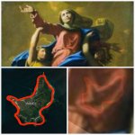
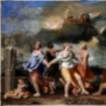
Mona Lisa, Megaliths and a Map

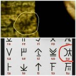
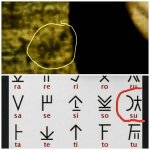
The map destination, step 1. This symbol is actually the first artifact I found several months ago that I could identify. I set up a Pinterest search for ancient alphabets, alchemy symbols, runes and scanned the feed every morning with my first cup of coffee. After almost 2 months, one morning the needle in the haystack showed up.

It is the Cypriot Syllabary symbol for "su" and is used in the context of a location or locating, like the german "zu" is used for "to" or "towards". A symbol associated with a location. Has anyone else found this in the past? Nope, not that I kind find.

And I made it the logo for my hobby.

So, where is it and what is there on the ground. From painting to ground destination, next post. Screenshot_20210127-224235_Photoshop%20Express.jpgPSX_20201224_093910.jpgIMG_20210110_220649_475.jpg
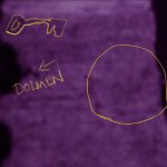
 

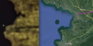
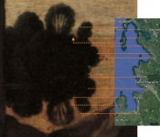
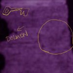
In the spirit of your logo (which I can't help but title, "Hey, this call's for you"), I went back to the 'tree reflection' outline from the painting and carefully compared it side-by-side to the GE image. Granted, the shoreline profile isn't an exact match, but it's pretty damned close enough. To register the comparison, I used the little offshore island and the distinctive points of land to its southeast. It's quite likely these positions are exactly as they were in the 16th century. Besides, the painter apparently made a point of including that island - a small detail he could easily have ignored.

When I compare the two, the first thing I notice is that the 'dolmen' shaped thing on the painting actually (to me anyway) corresponds quite closely to the delta region of the River Vilane. Is there also a dolmen nearby that displays this profile, and if so, from what perspective? That part of France is littered with megalithic monuments and you've pointed one out in particular. My curiosity wouldn't be satisfied until I visited the site in person. I had a similar itch some years ago that compelled me to see for myself the village of Rennes-le-Chateau in the French Pyrenees mountains. It wasn't easy getting there, but I'm glad I did.

I'm not denying your theory, just observing things. One question nobody's asked yet is what do you propose is at the end of the road?

Screen Shot 2021-01-28 at 8.31.18 AM.png
 

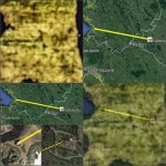
You marked the same estuary I did. great. the yellow line connects the megaliths. dolmen on left. While France has the most megaliths, these are unambiguous in there locations and relative isolation from other megaliths. And yep, I noticed the little island.

I think we are in sync. Next post is Chateau Bu.PSX_20210127_152019.jpg2021_01_05_18_12_40_904.jpgScreenshot_20210123-073636_Gallery.jpg
 

Fascinating stuff, the one image of the 7 type symbol with the King? image is awesome . I see so much that i have seen out here in the southwest . Even the sky window image in the dolmen can be found out here. Its got my advanced apophenia kicked in high gear. Thanks for sharing it. Its a great discovery to me. Looking forward to more.
 

Do you have any coordinates for Chateau Bu? I can't find it on Google Earth.
 

Do you have any coordinates for Chateau Bu? I can't find it on Google Earth.
sure. Saint-Just area, just west of the village.
lat 47.765044 lon -1.985020

thanks for checking it out.
 

Did you find anything of importance down by Noirmoutier?
I do not know that reference. I am just following these bread crumbs but dont know the area at all.

Learning as i go, sort of the point for a hobbyist.
 

Why would I share this information freely if it were such a great discovery? In case you were wondering, I have no resources to do anything more with this, but I hope to interest those that do have the resources.
 

Did you find anything of importance down by Noirmoutier?

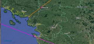
Wow, dog - great clue, very interesting! The village of Noirmoutier is almost exactly on the great circle line that connects the Egyptian obelisk in the center of St. Peters Square at the Vatican with the Money Pit on Oak Island, Nova Scotia, 3731 miles away. As you know, I don't believe in coincidences, especially with spherical geometry.

Screen Shot 2021-01-28 at 6.34.27 PM.png
 

Last edited:
Why would I share this information freely if it were such a great discovery? In case you were wondering, I have no resources to do anything more with this, but I hope to interest those that do have the resources.

If you could shed some light on what you think the prize may be, even indirectly, we might have a little more to work with. I'm glad you've shared what you have so far, as it's intriguing.
 

Wow, dog - great clue, very interesting! The village of Noirmoutier is almost exactly on the great circle line that connects the Egyptian obelisk in the center of St. Peters Square at the Vatican with the Money Pit on Oak Island, Nova Scotia, 3731 miles away. As you know, I don't believe in coincidences, especially with spherical geometry.

View attachment 1898022

That is an excellent line and I'm sure you know what is on both ends of it, with many interesting things between.

Sluggozim61 I understand what you've found with the painting and the mapping but how did you determine what direction to go.
 

Why would I share this information freely if it were such a great discovery? In case you were wondering, I have no resources to do anything more with this, but I hope to interest those that do have the resources.
To me,what you found hidden in those paintings and the techniques you used to expose them is a great discovery and secret .
 

Great question. I actually found this symbol first. Cypriot Syllabary symbol for su, similar to german zu meaning to or toward. So, I suspected where he wanted us to go, but at the time, I did not know where or what was there.

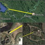
When I recognized the coastal profile and alignment, I created the overlays and was blown away. When I zoomed in on the aerial image, a megalithic complex at St. Just appeared, with Chateau Bu, a chambered cairn.

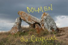
For the overlay, on the aerial image, i connected Dolmen du Crapaud and Chateau Bu, stone to stone, with a yellow line, and then displayed the end points. The overlay of the symbols in the painting and the megaliths on the ground is incredibly accurate, thus my confidence in what I am presenting. Painting to ground.

p.s.: Data about Chateau Bu indicates it had been rebuilt and the estimate was during the Bronze Age, about 1600 BCE. I am trying to locate the archaeological studies that generated that provenance. And the artifacts that determined the rebuild dating. Perhaps the rebuilding happened later, say around 1200 AD, and the site was repurposed to preserve and protect something very precious. my speculation, given Da Vinci's involvement.

onwardScreenshot_20210127-224235_Photoshop%20Express.jpgPSX_20201224_093910.jpg2021_01_05_19_33_25_347.jpg
 

That is an excellent line and I'm sure you know what is on both ends of it, with many interesting things between.

Sluggozim61 I understand what you've found with the painting and the mapping but how did you determine what direction to go.
i just noticed if you extend your megalith line down to the lay line, it goes right thru Hoedic Island. Wow! That is a Poussin connection to this same area! Posted here earlier.PSX_20210127_161003.jpg
 

Excellant secret stuff. Even the window created in the Poussin painting you just posted that the two arms makes along with the symbol in the center i have seen out here. Along with the horse head above and right of your web site symbol i have seen. All have been at great sites. You have revealed secerts and have really helped me with my advanced mental issues.
 

Have you ever done any work on this Poussin painting sluggo?View attachment 1898180
Nope, but here is how i start a poussin. a liitle blur and contrast. That canopy tree upper left is his "tell". Artifacts galore. I will have to come back to this one. Thanks.
sluggoPSX_20210129_110851.jpg
 

Top Member Reactions

Users who are viewing this thread

Back
Top