Misc data and adventures of a Tayopa treasure hunter

The letters in the drawing make no sense . Would make sense if convert them in numbers .
 

Hola Oro amigo no apologies needed. I will continue the yarn about this mysterious fate of the Santa Ysabel (the Almiranta )

A much larger and costlier expedition had been planned by the early 1590s, after Mendaña had spent years courting favour in Madrid and Lima. he had Four ships and 378 men, women and children were to establish a colony in the Solomon Islands. However fate can be a fickle thing because the leaders of this voyage had “widely divergent personalities. Mendaña was again in command, accompanied by his wife Doña Isabel Barreto, her three brothers and a sister. Chief pilot was to be a young Portuguese navigator in Spanish service, Pedro Fernandes de Queirós. The main protagonist was an argumentative old soldier, Pedro Merino Manrique was chosen as camp master. Manrique caused problems before the fleet had even departed. Sadly it was a sign of things to come.

The four ships, San Gerónimo (the Capitana), the Santa Ysabel (the Almiranta), the smaller frigate Santa Catalina and the galiot San Felipe left Callao on 9 April 1595. Spirits were high in the first month, fifteen marriages being celebrated. Mendaña had Queirós prepare charts for his Captains that only showed Peru and the Solomon Islands. Such was the confidence of their project.

On 21 July 1595 the ships reached the Marquesas Islands, (named for the wife of the then viceroy of Peru, García Hurtado de Mendoza, 5th Marquis of Cañete) to be met by four hundred people in canoes. Although the Spaniards admired their “graceful shape” and “almost white” complexion, the relationship with the natives later deteriorated into bloodshed. When the expedition left two weeks later, Queirós estimated 200 Marquesans had been killed. It seemed the Spanish still had not learned its lessons.

Despite Mendaña’s confidence that the Solomon Islands were nearby, it was not until 8 September that they sighted land again, this time the island of Nendo, which they named "Santa Cruz" to east of the Solmon islands. The ship Santa Ysabel had disappeared, however, and despite searches by the two smaller vessels, it could not be found. What happened to this ship is a mystery of history?

The remaining 3 ships Arriving at what is now Graciosa Bay, a settlement was commenced. Relations with local islanders and their chief Malope started well, with food provided and assistance in constructing buildings. However, morale amongst the Spanish was low and sickness (almost certainly malaria) was rife. Manrique made himself such and pain and a threat to the leadership that he was murdered at the orders of, and in front of Mendaña, and shortly afterwards,

Malope the chief was killed by soldiers. Relations with the Islanders soon worsened. Wracked by internal divisions and an increasing death toll, the settlement began to fall apart. Mendaña himself died on 18 October 1595, leaving his wife as heir and governor, her brother Lorenzo as captain-general. On 30 October, the decision was made to abandon the settlement. When the three ships departed on 18 November 1595, forty-seven people had died in the space of one month.

Pedro Fernandes de Queirós is credited with bringing the San Gerónimo safely into the Philippines without the aid of charts, arriving in Manila Bay on 11 February 1596. Over fifty people died on the twelve-week voyage from Santa Cruz, in part due to the lack of food supplies and allegedly Doña Isabel’s refusal to share out her private store of food and water. The frigate (carrying Mendaña's body) disappeared during the voyage, while the galiot San Felipe arrived in the southern end of Mindanao several days later.

The Spanish Colonization of the Solomon islands as you can see was a total disaster.

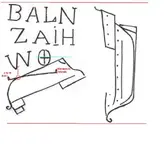
Yet a great mystery was born for those tragic events, which was the mystery of the fate of the the Santa Ysabel that was open to much speculation? Many years ago a carving on some coral stone was found that might give a clue to fate of the vessel?

As you can see in the pictures below.

View attachment 1221194

Was it a clue to fate of Santa Ysabel? Or just meaningless scribble?

What you might find interesting the ship was carrying considerable money to trade with the Philippines as the colony got established.

Kanacki

Thanks Kanaki....
Quite mysterious drawing...Please Do continue this and other yarns as the cold and rainy season is setting in,and hence a good time for the tantalizing treasure yarns..

TT
 

I believe the drawing says :

Barco A Latitud Norte
2*41'98"
West hemisphere
 

Last edited:
Questions lead to question...
The rumor of a cannon found near as well as a possible rescue add more questions.

https://secretvisitors.wordpress.com/2011/03/20/the-spanish-proclamation/

Yes , they tried to give a scientific explanation to a crypted map , which IMO is far away from a treasure hunter explanation .
To be clear , i want to give my own theory on this map .

The ship from the right has the dimension of all the other description from the left , so the description/code refers to this ship .
The oval/round shape with the cross is a description of the World with the four hemispheres . The ship which is up side down ( sunken ) is below the Equator ( blue line ) , so is in the south hemisphere .
The line with the limits is the longitude , and measure from the last point where they disembarked ( Marquesas Islands ) to the limit of the East to West hemisphere . Also this longitude line is on their planned route to the Solomon Islands which i believe was at 10* or 11* Lat in the south hemisphere .
The point (about the 20% of the line from the left ) which intersects their route with the sunken ship ( red circle ) , is the point from where we have to make the measurements which are given in the coded map .
The first line of the letters are initials of words which mean Barco A Latitud Norte . And this means north from the route and clearly , from the red circle .
The second line of letters are the code of the Latitude , and if convert the letters to numbers we have 24198 which IMO corespond to 2*41'98 .
Now , the result . If we go the coded coordinates to the north from the red circle , the possible place where the ship sank , is close by or to the Atafu Island .

Just my humble theory which I hope to be the right .

spanish-proc1.jpg
 

Last edited:
Wow.
I know very little of nautical signs etc. But I was able to follow that.

Well thaught out and explained.

<};0):-
 

Questions lead to question...
The rumor of a cannon found near as well as a possible rescue add more questions.

https://secretvisitors.wordpress.com/2011/03/20/the-spanish-proclamation/

Hola releventchair

Thanks for the link. It is indeed hard to know the Provence of such markings. Definitely more questions than answers. For me I cannot come to any definite conclusion about them. For me the story of from Journal of shipwrecked sailor in the Solomons published in 1871. He mentions the discovery of Grave of Spaniard and 40000 English pounds worth of treasure. Was it true or a blend of fact and fiction?

One thing for sure many ships was plundered, including whalers, sandalwood collectors, beach der mer hunters, traders, and black birders and crews massacred by Solomon islanders native right up to the late 1920's. Since the native culture there was for barter or stealing what useful they needed, gold and gems did not have western concept of value. Many such decorative items plundered from ships ended up on idols hidden away from missionaries. The where abouts since lost due inter tribal warfare, western punitive expeditions, disease and loss of cultural identity. those sites and hidden treasure remain hidden and buried all over the Solomon islands.

Kanacki
 

Yes , they tried to give a scientific explanation to a crypted map , which IMO is far away from a treasure hunter explanation .
To be clear , i want to give my own theory on this map .

The ship from the right has the dimension of all the other description from the left , so the description/code refers to this ship .
The oval/round shape with the cross is a description of the World with the four hemispheres . The ship which is up side down ( sunken ) is below the Equator ( blue line ) , so is in the south hemisphere .
The line with the limits is the longitude , and measure from the last point where they disembarked ( Marquesas Islands ) to the limit of the East to West hemisphere . Also this longitude line is on their planned route to the Solomon Islands which i believe was at 10* or 11* Lat in the south hemisphere .
The point (about the 20% of the line from the left ) which intersects their route with the sunken ship ( red circle ) , is the point from where we have to make the measurements which are given in the coded map .
The first line of the letters are initials of words which mean Barco A Latitud Norte . And this means north from the route and clearly , from the red circle .
The second line of letters are the code of the Latitude , and if convert the letters to numbers we have 24198 which IMO corespond to 2*41'98 .
Now , the result . If we go the coded coordinates to the north from the red circle , the possible place where the ship sank , is close by or to the Atafu Island .

Just my humble theory which I hope to be the right .

View attachment 1221689

Hola Marius There is a lot to like of your theory I like very much how you come up with especially lat north of equator. However I not clear how you come up with the longatude?

Kanacki
 

Hola Marius

The earliest maps have the equator marked on them, but it wasn't until the late 19th Century that the prime meridian was named. Until that time, as many as 14 different locations were being identified on various maps as 0 degrees longitude. The International Meridian Conference of 1884 changed all that, naming an imaginary line drawn through Greenwhich, England, as the prime meridian. I suspect you have worked off the Spanish or Portuguese concept prime Meridian. With 16th century navigation longitude was still a major issue for navigators. Still I like thinking you applied for latitude.

Kanacki
 

Hola Short finger you know your weather well. My island is in between northern and southern convergence zones. I have been keeping any eye of that as well one that looks like its forming north east of Marinas. A few months ago I sailed in between to Cyclones in one which destroyed Vanuatu they spin the opposite direct to Northern Hemisphere typhoons. I am hoping to visiting Canton island there is only about 24 people living there. 10 of them are kids. My wife is getting gifts to give for the visit. I have been told they have not had outside news for 2 and a half years.

Kanacki

Well, Nora won't be a problem for you, but there sure seems to be something forming near the Marianas. I don't often track anything west of Hawaii, but since i know that you may be out and about in the area, I may have to keep a better handle on the western Pacific as well. If you do get a chance to visit canton Island, I think we would all be interested in the story.

JB
 

Have to agree with this 100%. It takes a special breed to live on the open sea, and for me, if the boat got out of sight of land - forget it! I do love the sea and love boats, but can only swim just SO far. You and the Unholy Trio have my respect amigo, however I don't think I could handle going to sea the way you do.

Please do continue, apologies for the opinionating. :occasion14:

:coffee2: :coffee2: :coffee2:

No worries, Oro. This particular thread is wide open for opinionating. Your input is always welcome.

:coffee2::coffee2::occasion14:

JB
 

Hola Marius There is a lot to like of your theory I like very much how you come up with especially lat north of equator. However I not clear how you come up with the longatude?

Kanacki

Agreed, very interesting. My major question at this time is, how did this marking get to the Bondi Beach area, if the shipwreck occurred at the suggested latitude? Seems like a pretty long distance away....

JB
 

Hi Kanacki

My explanation about the longitude was made not in accordance with the 1595 period but in accordance with the earth sign with the four hemispheres ( the circle with the cross ) . The person who made this sign was aware of the four hemispheres and maybe is correct the theory how was made after the time period of the ship from the right .
My theory is a mix of the map and the 1595 expedition . All would be changed if the map is for other ship or other expedition .
 

Top Member Reactions

Users who are viewing this thread

Back
Top