Map Dowsing Request For Large Gold Mining Claim

GoldenGringo

Jr. Member
Jul 14, 2024
40
41
Las Vegas, NV
My mom is a pendulum dowser for yes/no questions only, so I know this stuff is real even though I’m perfectly fine with not understanding how it works.

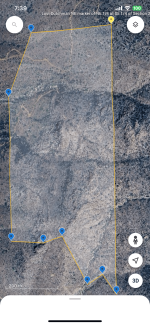
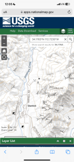
I recently acquired a large mining claim on the West slope of Rich Hill next to Stanton, AZ in the Weaver Mountains and mining district. This claim was owned by the Lost Dutchman’s Mining Association since 1983 and they never developed it for mineral production. They just let their members, the majority of them elderly, walk the claim with metal detectors. But I am told that LDMA members hardly ever accessed the entire claim because of the steep topography of the southern 1/2 of the 120 acres. There have also been multiple failed attempts by others to stake lode claims over the main placer claim in the hopes of locating quartz veins of gold ore. No operational permits for lode mining have ever been issued by the BLM and the staked lode claims would all be abandoned after their initial year.

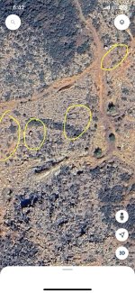
I’d like to have dow sets check some photos of the claim as well as Google Earth maps via gps coordinates I will provide below. I have recently found and read a 1988 geological survey and mining feasibility report for the 40 acres of patented mining claims that intersect the northern 1/2 of my claim. I’ll save the details of that report for later after you’ve dowsed the area for large nuggets and ore veins.

Let me know if you need any additional details or screenshots! thank you!

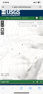
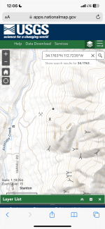
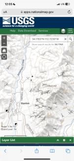
Roughly the center of my claim: 34.1763°N 112.7235°W

IMG_4147.png
img_4148-png.2159134
 

Attachments

  • IMG_4148.png
    IMG_4148.png
    1.8 MB · Views: 82
Topo map of the target area
 

Attachments

  • IMG_4172.png
    IMG_4172.png
    882.8 KB · Views: 10
  • IMG_4171.png
    IMG_4171.png
    1.1 MB · Views: 9
  • IMG_4169.png
    IMG_4169.png
    1 MB · Views: 10
  • IMG_4170.png
    IMG_4170.png
    1,003.6 KB · Views: 11
I once had a GPAA membership and still get the emails to please get lifetime Lost Dutchman Mining association membership. There have been nuggets recovered from the slope, by cracking open a granite boulder with a thin quartz vein showing on the side. On top of Rich Hill early miners turned over every square foot of dirt. Rock houses where up there, I would think some remains of them could be found.
 

Be careful of large rattlesnakes around Rich Hill. If you're careful of snakes, a prospector metal detecting, recovered a 10-ounce nugget from under the side of a large boulder.
 

I once had a GPAA membership and still get the emails to please get lifetime Lost Dutchman Mining association membership. There have been nuggets recovered from the slope, by cracking open a granite boulder with a thin quartz vein showing on the side. On top of Rich Hill early miners turned over every square foot of dirt. Rock houses where up there, I would think some remains of them could be found.
Yes! The remains of the rock houses are still up there. Check out 34°10'34"N 112°42'39"W
 

Attachments

  • IMG_4225.jpeg
    IMG_4225.jpeg
    609 KB · Views: 15
Be careful of large rattlesnakes around Rich Hill. If you're careful of snakes, a prospector metal detecting, recovered a 10-ounce nugget from under the side of a large boulder.
Was he searching the side/slope of Rich Hill? My claim also includes a relatively flat portion of the large alluvial plain that fills a gulch that drains the top of Rich Hill and flows all the way down into Antelope Creek
 

I did map dowse that claim in a thread here once, don't remember where or how to find the thread. Your map are in closer and much better.
 

I once had a GPAA membership and still get the emails to please get lifetime Lost Dutchman Mining association membership. There have been nuggets recovered from the slope, by cracking open a granite boulder with a thin quartz vein showing on the side. On top of Rich Hill early miners turned over every square foot of dirt. Rock houses where up there, I would think some remains of them could be found.
Yes! The remains of the rock houses are still up there. Check out 34°10'34"N 112°42'39"W

Attachments​

  • IMG_4225.jpeg
    IMG_4225.jpeg
    609 KB · Views: 0


In the old days of metal detecting. A treasure hunter went up there and his story got published in a treasure hunting magazine. Back then a famous western movie actor would spend his days off on Rich Hill prospecting for gold.
 

Last edited:
I did map dowse that claim in a thread here once, don't remember where or how to find the thread. Your map are in closer and much better.
You did? Wow, I’m going to have to use the advanced search feature and track down that thread! Do you recall what year you posted the thread? Approximately how long ago?
 

Yes! The remains of the rock houses are still up there. Check out 34°10'34"N 112°42'39"W

Attachments​

  • IMG_4225.jpeg
    IMG_4225.jpeg
    609 KB · Views: 0
Like Gift Quote Reply
Report

In the old days of metal detecting. A treasure hunter went up there and his story got published in a treasure hunting magazine. Back then a famous western movie actor would spend his days off on Rich Hill prospecting for gold.
What was the name of the actor?
 

Be careful of large rattlesnakes around Rich Hill. If you're careful of snakes, a prospector metal detecting, recovered a 10-ounce nugget from under the side of a large boulder.
Was he searching the side/slope of Rich Hill? My claim also includes a relatively flat portion of the large alluvial plain that fills a gulch that drains the top of Rich Hill and flows all the way down into Antelope Creek


I'm thinking this was near the one top side or somewhere close to the creek, don't know for sure, read it in an old treasure hunting magazine story.
Thanks Red! I’m looking for your old Rich Hill dowsing thread
 

I did map dowse that claim in a thread here once, don't remember where or how to find the thread. Your map are in closer and much better.
You did? Wow, I’m going to have to use the advanced search feature and track down that thread! Do you recall what year you posted the thread? Approximately how long ago?


Don't know how long ago, it was in a thread by username dowser. I think I could find it with advanced search.
 

What was the name of the actor?


Don't remember the name, person in treasure magazine article said, "he showed me one of the fake gold nuggets they used in movies."
 

In rock house map, was getting hits in these areas. I know quartz veins are supposed to be in granite, they don't have clue as to how deep down they go.

IMG_4225-rock-houses.jpeg
 

In rock house map, was getting hits in these areas. I know quartz veins are supposed to be in granite, they don't have clue as to how deep down they go.

View attachment 2159384
i’ve read the shafts on the east side of rich hill go down to the 1800-2000 foot level.

if that target you dowsed is a vein, i wonder which way it is traveling? my claim lies immediately below that spot on the top of rich hill, about 100 yards down the west slope of the hill
IMG_4167.png
IMG_4168.png
 

I want to check your claim maps. There are a few old mines in the area shown on old topo maps. On a Stanton LDMA outing, a gold nugget it's weight in lbs. was dug near an access road detected with a Minelab.
 

I want to check your claim maps. There are a few old mines in the area shown on old topo maps. On a Stanton LDMA outing, a gold nugget it's weight in lbs. was dug near an access road detected with a Minelab.
Whoa! Do you have any idea how long ago that was? I’d like to try to research that discovery and see what i can find as far as pictures and eyewitness accounts go
 

Top Member Reactions

Users who are viewing this thread

Back
Top