Llanganatis Mountains: Valverdes Gold

It took me many years to locate a copy of Fever, Famine and Gold by Capt. E. Erskine Loch. It took me more years to find a copy in collectible condition at what I considered to be a reasonable price.

I finally came across one, purchased it, and read it. It's an entertaining adventure story but it provides remarkably little actual useful information about the treasure. It's listed in all the bibliographies, of course. I simply don't think it is going to be of great assistance to the serious hunter for the treasure.

Good luck to all,

The Old Bookaroo
 

Hello All

Just a few more interesting points

There are no references to Valverde in the context of the legend prior Richard spruces publication of the Map and Derrotero? ( first publication 1861 and later 1863 )

Interesting to note Richard Spruce claimed the map he copied from was dated 1827. As for a poor solider called Valverde? At this point in time there has been no record of this man. Conveniently Richard Spruce states that the records was kept in records of the Corregidor of Tacunga. But in the course of time the documents were lost.

Or any record at this point in time of Padre Longo who allegedly searched for this treasure before De Atanasio Guzman.

If you go back to earlier documents of the events of the ransom of Atahullpa. The Spanish main push was toward the capital of Cuzco which was to the Inca the navel of the World, Where the conquistadors found treasure beyond wild imaginations.

Its was in some of the earliest chronicles when the Spaniards looted Cuzco, torturing the inhabitants in a gold lust for more and more gold, they discovered much gold did not get sent for the ransom. At the time Inca General Ruminavi was in revolt in the north it was assumed that he had held up shipments from the north. Perhaps the start of the legend of Ruminavi removing the remaining gold back north to Ecuador.

Another book worth looking at is on page 312 "Modern History or Present state of all nations" By Thomas Sulman 1746.

But perhaps the Llanganatis legend is corruption of earlier events via hearsay over time?

One of important figures in these events of time of Atahuallpa's execution was a Dominican monk named Vincent De Valverde. Who in some books painted him a hero of the natives and others as a monster. Never the least he was made first bishop of Cuzco.

Strange enough! It was a later Bishop from this very Dominican Monastery in around 1620 that had a lay brother who claimed he had found a location where much treasure was hidden and prepared a map. The Bishop had known how much destruction the conquistadors had wrought on the population in the past. Sent the information back to the Vatican away from the Spanish vice royalty.

This Document and Map was allegedly found by an Italian Peruvian archeologist in the late 90's. The directions on the map is as always double meaning and in a style that is open for interpretation.

Hence the mystery of the missing Inca treasure continues....

Crow

Hi Crow

Long time have passed from our posts about the Llanganates treasure . I hope you are doing fine and your life rolls like you have dreamed it .
The directions which have double meaning on the Bishop map go like these ? :

" Go from the Sun's column , where the Sun's Road crosses the Moon's Road , and walk north on Moon's Road , until you reach the Moon's column , and from there go farther until you get to the Thunderbolt column. Then turn back to the Sun's column and go on the Sun's Road westward 400m until you get to a maple tree . On the same way going eastward , 600m from the Sun's column, you'll get to a sycamore maple tree . "

I have to admit is a tricky puzzle but not very hard to resolve it using the Menelaus's theorem , and knowing where the " Sun's Road " lies .
 

Last edited:
Seems Crow has better things to do than answer to my post . Or , maybe he don't has the details of the Bishop document , hence his post referred to him was a copy-paste article from " anecdotal research " of this site : Clues and maps to find Atahualpa's Incan Gold | The Expedition Consultancy Ltd

Some researchers believe how you need only a pair of boots and strong legs to find a treasure , but IMO these are not enough . The guys who made the maps for those treasures , used more brain than legs , and they were addressed to intellectual folks who use their brain too .
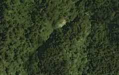
Bellow I post an aerial image ( not GE ) of the " Reclining woman " boulder ( red circle ) from the Captain Blake's map and the hill like a " Church porch " ( yellow triangle ) from Valverde's derrotero . Is nice to have in your collection pictures like these .

4tl.jpg 4tl #2.JPG

Have a nice weekend .
 

Last edited:
Seems Crow has better things to do than answer to my post . Or , maybe he don't has the details of the Bishop document , hence his post referred to him was a copy-paste article from " anecdotal research " of this site : Clues and maps to find Atahualpa's Incan Gold | The Expedition Consultancy Ltd

Some researchers believe how you need only a pair of boots and strong legs to find a treasure , but IMO these are not enough . The guys who made the maps for those treasures , used more brain than legs , and they were addressed to intellectual folks who use their brain too .
Bellow I post an aerial image ( not GE ) of the " Reclining woman " boulder ( red circle ) from the Captain Blake's map and the hill like a " Church porch " ( yellow triangle ) from Valverde's derrotero . Is nice to have in your collection pictures like these .

View attachment 1643969 View attachment 1643970

Have a nice weekend .
Thanks and Greetings from Ecuador [emoji1092]
 

Books, books and more books. What about real and original documents?
 

Hello Vox

Many things in the legend has been blown out of context in books indeed.

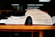
However there is a 4000 page 400 year old book that gives the location of where the last Inca Emperor Atahualpa is buried. Discovered by a historian Tarama Estaupian

DSC_0164.jpg

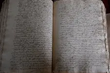
Here is the page concerning the description of burial of site Atahualpa forgotten and undiscovered by authors historians and treasure hunters for 400 years.

location of last inka emporer altahalpa.jpg

The researcher stumbled across Atahualpa's son Franciosco Topataunchi the last will and testament dated 1583 50 years after his fathers death. Its gives a list of properties he held. One was a site near Sigchos.

The researcher discovered the rulers mummy was referred to Malqui. She found an old map with Machay which means in the Inca language final resting place. Near an area called Sigchos. A search of the Area discovered an amazing archaeological site.

Kanacki
 

Last edited:
Here is picture of Tarama Estaupian with book in Archives of Quito.
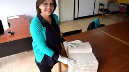
58c469cdcd7b7.image.jpg

The telegraph newspaper rep on the find below.

This is an absolutely important find for the history of Ecuador's archeology and for the (Andean) region," said Patrimony Minister Maria Fernanda Espinosa, speaking of the ruins found by Ecuadoran historian Tamara Estupinan.

The Inca empire, in the 1400s and early 1500s, spanned much of South America's Andean region, over 1,000 miles (1,600 kilometers), from modern-day Bolivia and Peru to Argentina, Chile, Ecuador and Colombia. It included dozens of ethnic groups with different languages, cities, temples, farming terraces and fortresses.

Atahualpa was the last of his dynasty. During the Spanish conquest he was taken captive in what is now Cajamarca, Peru.

He had been pressed to convert to Christianity and then the Spanish executed him by strangulation, then after his death in 1533, the empire began to fall apart.

This year Ecuador's state Cultural Patrimony Institute will start work on a promising archeological site, and Estupinan will be front and center to raise the curtain on a massive complex sprawling over a ridge at 1,020 meters.
maxresdefault.jpg

It was back in June 2010 that Estupinan, now a researcher with the French Institute for Andean Studies (IFEA), found what she describes as an "Inca archeological site" high on the Andes' eastern flank amid plunging canyons. Nearby are a small local farm and a facility for raising fighting cocks.

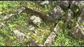
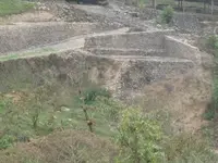
But in the area called Sigchos, about 45 miles south of Quito, up on a hill dotted with brush, there is more - much more: she found a complex of walls, aqueducts and stonework that lie inside the Machay rural retreat. Machay means burial in the Quechua language.

"This is a late imperial design Inca monument that leads to several rectangular rooms that were built with cut polished stone set around a trapezoidal plaza," Estupinan explained to AFP.

Archeologist Tamara Bray, of Wayne State University in Michigan, and a colleague of Estupinan, confirmed that the site boasts "an Inca edifice that is phenomenally well preserved and quite important scientifically."

Inside the facility, a walled walkway starts at the Machay River and one can see the shape of an "ushno", essentially stairs that form a pyramid believed to be the (capac's) emperor's throne. Meanwhile a tiny cut channel of water would spout out a small waterfall nicknamed "the Inca's bath".
IMG_5204.jpg

The director at the Lima-based IFEA, Georges Lomne, said the find appears to confirm that the Incas were active and present in a lowland area well outside what their best-known area of operations were: Andean highlands.

"Malqui-Machay is part of a broader complex that also would have included the Quilotoa lagoon and the area called Pujili (Cotopaxi)," he explained.

"All of this belonged to Atahualpa. It was his personal fiefdom in the way that French (and other) kings had royal domains," Lomne added.

Bray also stressed that "very few such Inca sites have been found in this type of tropical lowland. I think that the Incas used it as a sort of getaway."

Estupinan has some more specific ideas.

She believes Malqui-Machay is Atahualpa's final resting place. The tomb of the last capac (emperor) of Tahuantinsuyo, the trans-Andean empire.

While many experts have other theories, Estupinan believes that when Atahualpa was killed his remains could have been brought by his most loyal man, Ruminahui, to Sigchos for burial, to a place where Ruminahui based his fight for survival against the European intruders.

If this site is ultimately proven to be true then it challeges other theories that Atahalphas tomb is some where in the Llangantis?

Kanacki
 

Last edited:
Of course that I should add. Even thou if Atahalpa grave or tomb is actually the final resting site at Sigchos? Valverde's deterreo might not be directions to Atahalpa's tomb but an incomplete guide to some of the Incas ancient gold working areas?


But the fact remains neither Mark Honigsbaum or others who did very though research and visited the archives des Indes and searching through in correspondences section found not one shred of Documentation pertaining to Valverdes deterreo. But he did find some thing else very interesting.

Its late.......

Kanacki
 

Last edited:
Legend has it. Valverde, a Spaniard who some 50 years after Atahualpa's death is said to have become rich after being led to the gold by his Incan bride's family. When he died, he left written directions to its location, the so-called Derrotero de Valverde.

In Mark Honigsbaum's book Valverdes Gold there is comments on page 244 about a certain Pedro De Valverde in The Archivo General De Indies.

In 1568 Pedro De Valverde had been decorated for his service in the conquest of Peru. According to the Archivists notes Pedro had fought for the Royalists along side Blasco Nunez against the tyrant Pedro De Hinojossa, Gonzalo's Captain General. After Gonzarlos defeat by 1570. Gold began flowing out of Ecuador. Pedro de Valverde had been rewarded for loyalty and was appointed the accountant of the royal house of Quito with the responsibility of all the Kings treasury.
The accounts of sums of gold and silver page after page was enormous. A typical entry Fine Gold 22672 pesos: Silver 6302 pesos Beside each date recording when the money had been revived and when shipped to Spain. At the end of each page was same signature Pedro de Valverde.

Pedro's other responsibilities was payment of officials and overseeing of native labour for the mines. Each with his signature at the bottom of each document.

While its not known if he had married a native wife? But the most highly interesting that Pedro paid share payments to Francisco Ataballipa . Mark Honigsbaum speculated that this person was either Atahalpa's Son or Nephew? But given spelling variation in names between Spanish, Inca versions its hard to tell? But could these payments to Francisco Ataballipa just another name version of Franciosco Topataunchi? Or perhaps Francisco Ataballipa is not the son Franciosco Topataunch but grandson?

further digging found Francisco Ataballipa born 1524 is Athalpha's son as well as Franciosco Topataunchi

Franciosco Topataunchi died in 1583, Pedro de Valverde died in 1579. These payments was made in 1570's. What makes the gold share out payments interesting is a note "Works in the mines"

While family lineage is not 100% clear? What is clear some of Atahalpa's sons at least was working in partnership with the Spanish to mine gold between 1570-1579 facilitated by A Pedro de Valverde.


Kanacki
 

Last edited:
Hi Kanacki

with that much gold and silver being extracted, when did the mining cease ?
does gold and silver imply different mines/areas ? (gold placers, silver hardrock ?)
any idea of the # of miners involved ?
actual areas worked - or is that the hunt ?
 

Hello Bill my guess gold placers and later hardrock as alluvial deposits became harder to find. Silver production was no where near prolific in Ecuador in 16th century. The Real Audiencia de Quito, Real Cédula de 1563 consisted of Present day Ecuador and covered the northern half of present day Brazil. Many areas the Spanish never had full control of these regions. As the their was continued native uprisings after the collapse of the Inca empire.

The Spanish had about 500 encomiendas that housed about half the native population. Many of these ecomindas where never large enough to support themselves and failed even mining ones. Many of Spaniards who owned them preferred live in Quito than on their estates.

As you know from the "lost cities project" the two encomiendas involved was overrun and destroyed 3 times before being lost.

While the Inca empire might of crumbled mining could only commence with co operation of the local natives. That's is why most likely the sons of Atahalpha even thou not emperors still have some influence. No doubt the sons experience cross cultural benefits from doing business with Spanish.

That would be my guess why payments of gold was being shared with at least one sons of athalpha.

Kanacki
 

You might like to consider 3 schools of thought.

1: If the sons of Atahalpha was doing business with the Spanish there would be no need to hide any gold from the Spanish. Because they was getting their cut anyway?

2: Did Rumiñahui actually hide any gold to begin with? Early accounts are not clear that he hid and gold other than continue the resistance until he was captured and killed. It seems much later the legend morphed into Rumiñahui hiding gold?

3: The sons of Atahalpha had no knowledge of where Rumiñahui hide the remaining part of Atahalpha's ransom? Or perhaps the carriers of gold hid caches all over the trail on learning the Incas death. Rumiñahui in a fighting retreat from the Spanish would have very little time for organised a mass hiding of the treasure.

Many possibilities. As for the detterro we have no Provence of date of this alleged directions or even strong connection to Antonio Guzman who made a map of the region?

Me personally I think like Crow more people became enchanted by the legend than pursuing the facts....That's the dangers of such treasure legends it is easy to become intoxicated by them.

That said beyond that Ecuador was rich in gold and much was extracted over 400 odd years and its easy to be seduced by such stories. But where does the fiction ends and the truth begins?

Kanacki
 

Last edited:
Hi Kanacki

1/2 the native population enslaved ?
it is a wonder Spaniards are not killed on sight

In the beginning you could imagine some sort conclusion between culture in mining the gold with sheep skin in the rivers for alluvial gold. But in time the mining evolved in back breaking hard rock mining and rising productions cost as well as poor working conditions it is easy to see why there was revolts.

Kanacki
 

Hi Kanacki

with that much gold and silver being extracted, when did the mining cease ?
does gold and silver imply different mines/areas ? (gold placers, silver hardrock ?)
any idea of the # of miners involved ?
actual areas worked - or is that the hunt ?
In the Oriente they worked ancient river channels you can find the old workings around 2600 m above sea level
Its an old dry death river bed rich in gold .can't claim any concession its national park now .
 

Hello EK

This may be of interest.


Kanacki
 

An interesting but sad reality of gold mining and processing in some regions of Ecuador.


Kanacki
 

Here is some more sites.


Kanacki
 

Top Member Reactions

Users who are viewing this thread

Back
Top