in pursuit of Peralta's Trail through California
Old Spanish Trail (trade route) - Wikipedia, the free encyclopedia
Old Spanish Trail (trade route)
A route linking
New Mexico to
California, combining information from many explorers, was opened in 1829-30 when
Santa Fe merchant
Antonio Armijo led a trade party of 60 men and 100 mules to California. Using a short cut discovered by Rafael Rivera the previous year, the Armijo party was able to stitch together a route that connected the routes of the Rivera and Domínguez-Escalante Expeditions and the Jedediah Smith explorations with the approaches to
San Gabriel Mission through the Mojave along the
Mojave River. After this date, the route began to be used by traders for usually a single annual round trip.
Word spread about the successful trade expedition and some commerce began between Santa Fe and Los Angeles. This commerce usually consisted of one mule-laden pack train from Santa Fe with 20 to 200 members, with roughly twice as many mules, bringing New Mexico goods hand-woven by Indians, such as serapes and blankets, to California. California had many horses and mules, many growing wild, with no local market, which were readily traded for hand-woven Indian products. Usually two blankets were traded for one horse, more blankets were usually required for a mule. California had almost no wool processing industry and few weavers, so woven products were a welcome commodity. The trading party usually left New Mexico in early November to take advantage of winter rains to cross the deserts on the trail and would arrive in California in early February. The return party would usually leave California for New Mexico in early April to get over the trail before the water holes dried up and the melting snow raised the rivers too high. The return party often consisted of several hundred to a few thousand horses and mules. Low-scale emigration from New Mexico to California used parts of the trail in the late 1830s when the trapping trade began to die. The trail was also used for illicit purposes, namely to raid the California ranchos for horses and for an extensive Indian slave trade. These horse raids were made by Mexicans, ex-trappers and Indian tribes who together stole hundreds to thousands of horses in one raid. Native Americans, usually women and children, were captured and sold to Mexican ranchers, etc., in both California and New Mexico for domestic servants. Mexican traders and Indian raiding parties both participated in this slave trade. The consequences of this human trafficking had a long-standing effect for those who lived along the trail, even after the trail was no longer in use. Intermittent Indian warfare along the trail often resulted from these slave raids by unscrupulous traders and raiding Indians.
John C. Frémont, "The Great Pathfinder," took the route, guided by
Kit Carson, in 1844 and named it in his reports written up in about 1848. New Mexico-California trade continued until the mid-1850s, when a shift to the use of freight
wagons and the development of wagon trails made the old pack trail route obsolete. By 1846 both New Mexico and California had become U.S. territories as a result of the
Mexican-American War of 1846-1848, and after 1848 large numbers of
Mormon immigrants were settling in
Utah,
Nevada and
California all along the trail, affecting both trade interests and tolerance for the slavery of American Natives.
Place names used in this article refer to present-day states and communities. Few (if any) settlements existed along the trail before 1850, although many of the geologic features along the Trail retain their Spanish designation.
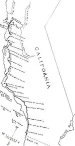
Description of Trail Route


The route of the Old Spanish Trail in southeastern Utah

Sevier River drainage basin

Virgin River drainage basin

Map of the Mojave River drainage basin
The central route of the Old Spanish Trail, which had to swing north to avoid the impassable
Grand and
Glen Canyons on the
Colorado River, ran northwest from Santa Fe through southwestern
Colorado, past the
San Juan Mountains,
Mancos, and
Dove Creek, entering Utah near present day
Monticello, Utah. The trail then proceeded north through difficult terrain to Spanish Valley near today's
Moab, Utah, where a ferry crossed the deep and wide
Colorado River and then turned northwest to a ferry crossing on the similarly sized and dangerous
Green River near present day
Green River, Utah. The route then passed through (or around) the
San Rafael Swell, the northernmost reach of the Trail. Entering the
Great Basin in Utah via Salina Canyon, the trail turned southwest following the
Sevier River,
Santa Clara River and
Virgin River before ascending the Mormon Plateau and hitting the
Muddy River in present-day Nevada. From there, it was a 55 miles (89 km) waterless trip crossing southern
Nevada to the springs at
Las Vegas, Nevada. From Las Vegas, the trail went across the Mojave desert from Mountain, Resting, Salt and Bitter springs (which were sometimes dry), each about a day's travel apart across the
Mojave Desert until it reached the only intermittently dependable
Mojave River. The river was followed to a point near
Cajon Pass over the
San Bernardino Mountains. If parts of the Mojave River were dry, travelers could sometimes find water by digging in the old river bed. Descending Cajon Pass to reach the coastal plains, the trail turned west along the foot of the
San Gabriel Mountains to where the
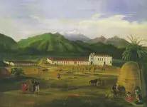
Mission San Gabriel Arcángel and
El Pueblo de Los Ángeles in California were located. In all, the route involved several dry sections with limited grass and sometimes limited water, crossed two deserts, and was often littered with the bones of horses that had died of thirst.[SUP]
[5][/SUP] The route could only be used semi-reliably in winter when winter rains or snows deposited water in the desert. In summer, there was often no water and the oppressive heat could kill. A single round trip per year was about all that was feasible. Later parts of the trail were used for winter access to California when other trails were closed by snow. Alternate routes for this journey existed through central Colorado and through the Arizona Strip.


![Old Spanish Trail Map_thumb[4].webp](/data/attachments/714/714854-ac98ed5c2f93fdcab515229a75b91254.jpg?hash=AlZ1JqDdy9)