BigRon
Full Member
- Joined
- May 22, 2007
- Messages
- 115
- Reaction score
- 0
- Golden Thread
- 0
- Location
- Richmond Texas
- Detector(s) used
- , BH Lone Star, BH Pinpointer, Homebuilt BFO, Index finger
These are some fantastic posts! Good luck on your hunt. What can you tell me about hunting the Nibletts Bluff area? My daughter lives nearby (Tx. side) and I was wondering if there was good hunting in this area.
Ron
Ron


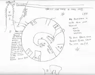
") He is planing to come for a visit after Thanksgiving. I have killed all the deer I want for the year and most of the hunters will be out of the woods by then. I have read about death traps and they do concern me so please do not worry. As far as any knowledge of niblets bluff I have read some stories but I cant think of what they say. I generally reread my books every other month and when I find something I will let you know. All the best
He is planing to come for a visit after Thanksgiving. I have killed all the deer I want for the year and most of the hunters will be out of the woods by then. I have read about death traps and they do concern me so please do not worry. As far as any knowledge of niblets bluff I have read some stories but I cant think of what they say. I generally reread my books every other month and when I find something I will let you know. All the best