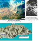
Jesuit map in a cave at Tayopa

Jose--- How long you in Tucson ??? There's a new area i'd like to check out if you have time. It's very close to nogalos.


? ? ? ? ? ? ? ? ? ? Jacko

~~~~~~~~~~~~~~~~~~~~~~~~~~~~~~~~~~~~~~~
]HOLA JACKO:? I have no idea, up to the VA.? However I am still too wobbly to go out into country much as I love doing so.? However I am doing just fine and soon----

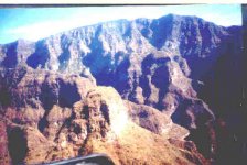
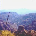
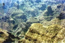
I am enclosing 3 photos of the Tayopa canyon, you can see what I was referring to on the topo? attempt.
 

Attachments

  • .jpgLooking up Tayopa canyon up to the mesa above.jpg
    .jpgLooking up Tayopa canyon up to the mesa above.jpg
    20.2 KB · Views: 2,459
  • .jpgTayopa canyon.jpg
    .jpgTayopa canyon.jpg
    27.5 KB · Views: 2,497
  • .jpgfolding downi western barranca.jpg
    .jpgfolding downi western barranca.jpg
    29.5 KB · Views: 2,441
HI:

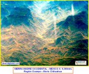
Someone could tell me where exactly were taken the 3 pictures of Tayopa canyon over this picture I took from from a jet fligth. Thanks.

CACHILAN
 

Attachments

  • TAYOPA-OCAMPO CHIHUAHUA FLY.JPG
    TAYOPA-OCAMPO CHIHUAHUA FLY.JPG
    84.1 KB · Views: 2,471
Someone could tell me where exactly were taken the 3 pictures of Tayopa canyon over this picture I took from from a jet fligth. Thanks.

CACHILAN

~~~~~~~~

A) HOLA, since you didn't orient the photo, I will have to assume from the shadows that it looking down the Rio Mayo to the south. Obregon lies out of the sierras. above to the right. In which case it would lie to the right of the picture at the extreme top end. South west extremities of the picture. Need co-ordinates? for Google?

Jose e La Mancha ( I tilt windmills )
 

That's some really neat stuff RT!!!

Nana ;)
 

Hi:

I guess these mini references could be helpful to identify the position where the pictures above were taken.

If coordinates were available, would be very helphul for me in order to make a good satellite georeferenced map and further remote sensing mineral and archeological analysis.

I am sure is possible to locate minerals and ?Antiguas? (Old spanish mines) combining my desk work with your field experiences. I have never been exploring that area on the field, but could be sure I have explored it in an exhaustive scientific remote way.

If actually is possible for NASA to detect a ?Gold Pot? in planet Mars using satellite remote sensing technology, would not be possible to locate Tayopa, Guaynopa, Guaynopita, etc. in our own planet ????

Mine is a search for the treasure of an Intellectual Triumph.

Best regards

CACHILAN
 

Attachments

  • OCAMPO-TEXT&TOPO REFERENCE-700.jpg
    OCAMPO-TEXT&TOPO REFERENCE-700.jpg
    114.8 KB · Views: 2,400
I? guess these mini references could be helpful to identify the position where the pictures above were taken.

A)? Yes, but I have to work from memory since I am presently in Tucson, not home in Alamos, Sonora, Mexico.? ?Yecora lies almost due north, some 40 miles,? Ocampo to the NW approx. 30 -40 mile, perhaps half way to the falls of Basaseachi.

According to this data it was taken in the morning hence it is looking basically East.
~~~~~~~~~~~~~~~~~~~~~~~~~~~~~~~~~~~~~~~~~~

If? coordinates were available, would be very helphul for me in order to make a good satellite georeferenced map and further remote sensing mineral and archeological analysis.

A)? try? ? ( 26 00 19,66 N? 108 56 20.04 W)? ?for the co-ordinates of the Capilla? ?(church) of Tayopa.? This works nicely with? "Google, Earth" , just rotate the original picture 180 degrees unitl thi canyons look like canyons not peaks, heheh..

~~~~~~~~~~~~~~~~~~~~~~~~~~

I am sure is possible to locate minerals and “Antiguas” (Old spanish mines) combining my desk work with your field experiences. I have never been exploring that area on the field, but could be sure I have explored? it in an exhaustive scientific remote way.

A) I have spent years in both.

~~~~~~~~~~~~~~~~~~~~~~~~~~~~~~~~~~~~~~~~~~~~~~~~

Mine is a search for the treasure of an Intellectual Triumph.

A) I agree on both , hehehe.

~~~~~~~~~~~~~~~~~~~~~~~~~~~~~~~~~~~~~~~~~~~~~~~

Mines, mules and me in old Mexico is a very nice book. It is basically about the Rupublica mine which lies north of Tayopa near Ocampo.? He mentions that they had 1500 mules working at the Republica mine alone, no wonder the old trails are so worn.

Jose de La? Mancha? ( I tilt windmills )

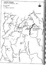
p.s. if I can get his scanner working, I will post maps? etc.? The one of the Sierras is of the locaton of the first Tayopa near Guaynopa/Guaynopita.? ? The true Tayopa, the one that everyne looks for and has the treasures that are associated wth it is #3,? mine. It lies south of this map.? The one near Yecora, at the bottom left side of the map,? is #2 "from the book by Adrian Westwood, "A treasure hunters Guide to Tayopa", I sugest buying it. an excellent little book.

(C)
 

Attachments

  • .jpgSierra Madre.jpg
    .jpgSierra Madre.jpg
    33 KB · Views: 2,399
  • .jpgMules, mines, and me in old Mexico.jpg
    .jpgMules, mines, and me in old Mexico.jpg
    15.3 KB · Views: 2,301
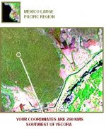
Thanks for your Morris map. I am sure we can interchange interesting info. I really don't use the Google, Earth as I have more advanced satellite and remote exploration tools. I found the coordinates you sent me for the "supposed" chapel in Tayopa #3 but they are located 260 Kms. south of Yecora and that really is not in the true "range" of the Sierra Madre.

26? 00' 19.66'' is far from the sierras in Chihuahua-Sonora limits.

I could not understand well about "p.s. if I can get his scanner working, I will post maps etc".....you meant "this" or "his" ?

Take a look to the images I got.

CACHILAN
 

Attachments

  • Tayopa CHAPEL Collagge.JPG
    Tayopa CHAPEL Collagge.JPG
    34.7 KB · Views: 2,280
Where is the "Matador" Jose De La Mancha, I would like to exchange info with him on this forum or in a private mail.

I have almost georeferenced and translated the Dobbie's map to topographic and satellite images using multiple advanced tools and high correlated historic research. Even locating and analyzing the possible minerals and bonanzas around as well as the existing rests of arrastras, wood, old metals and tools, water pits
guerigos, madronos, tepueste (real name tepustete), human bones, etc., etc, etc.

I guess it could be helpful to speak native spanish, the knowing of catholic holly names words and understanding what "province" real means for jesuits.

Regards

CACHILAN
 

Where is the "Matador" Jose De La Mancha, I would like to exchange info with him on this forum or in a private mail.

I have almost georeferenced and translated the Dobbie's map to topographic and satellite images using multiple advanced tools and high correlated historic research. Even locating and analyzing the possible minerals and bonanzas around as well as the existing rests of arrastras, wood, old metals and tools, water pits
guerigos, madronos, tepueste (real name tepustete), human bones, etc., etc, etc.? ?

I guess it could be helpful to speak native spanish, the knowing of catholic holly names words and understanding what "province" real means for jesuits.

Regards

CACHILAN? ?

? ? ? ? ? ? ? ? ~~~~~~~~~~~~~

HOLA:? Sorry for the delay.? First ,I have to apologize on the co-ordinates,? that should read (28 00" 26.1560 N,? 108 56" 57.8662? W.)? ?(UTM? ?Y - 3 099,530.320? ? X- 701,634.01).? INEGI? map H12D87? ?typo booboo.

Of course we shall cummunicate, here might be better since others might like to read about it also.? Obviously, some information will not be posted. hehhehe.? Naturally in here we will speak English.

Incidentally, Dobies map is? almost 100% correct.? I only wsh that I had known this at the start, it would have saved me a lot of aspirin bottles.

I am returning to Tucson in the morning for perhaps 3 -4 weeks.? I will be in contact by wednessday.

Jose de La Mancha? ( I tilt windmills )

p.s. that was "his" scanner since I was using his computer system.
 

Hi Jose de la Mancha:

I have take a look to the above pictures of the Tayopa Canyon, but when has been mentioned in the related stories or history a "Ca?on de Tayopa ?

Considering the coordinates you provided to me, where is that canyon ? Or could you please send me the coordinates ?

Regards

CACHILAN
 

I have take a look to the above pictures of the Tayopa Canyon, but when has been mentioned in the related stories or history a "Ca?on de Tayopa ?

Considering the coordinates you provided to me, where is that canyon ? Or could you please send me the coordinates ?

? ? ? ? ? ? ? ? ? ? ? ? ? ? ? ? ? `~~~~~~~~~~~~~~~~~~

HOLA:? You have the excact surveyors? co-ordinates in my "last post", #31.. The large canyon that I designated as the tayopa canyon in post # 22 iis actually the Barbarrocas canyon which empties into the rio Mayo at San luis Barbarrocos,? the view is to the East. Looking down the canyon, Tayopa lies to the left (N) at the lower left corner of the picture.

As I mentioned, Dobies Map is almost 100% correct.? The canyons of Tayopa and Paramo open to the south,? not to the north as it suggests.? This is what most of the other seekers of Tayopa have failed to understand.

I am still in Mexico, my scanner does not work for some reason, I will get a new one when I return to Tucson, but perhaps you can post a copy of Dobies Map of Tayopa for others? to see?

Jose de La Mancha? ( I tilt windmills )

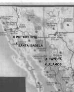
The spot marked "picture site" is of another thing.? That was when I backpacked alone into the Sierra de Los Gigantes" to examine ancient cliff pictographs


[attachment deleted by admin]
 

Attachments

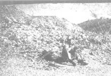
  • .jpgour helicopter comimg into the landing field at Cerochito Tayopa.jpg[1].jpg
    .jpgour helicopter comimg into the landing field at Cerochito Tayopa.jpg[1].jpg
    13.1 KB · Views: 2,174
  • .jpgMAP WITH PICTURE SITE, SANTA ISABELA, ALAMOS, AND TAYOPA LOCATED..jpg
    .jpgMAP WITH PICTURE SITE, SANTA ISABELA, ALAMOS, AND TAYOPA LOCATED..jpg
    25.1 KB · Views: 2,166
  • solo backpacking trip into the Sierra de La Gigante.jpg
    solo backpacking trip into the Sierra de La Gigante.jpg
    17.2 KB · Views: 2,190
RealdeTayopa:
"The large canyon that I designated as the tayopa canyon in post # 22 iis actually the Baroccas canyon which empties into the rio Mayo at San luis Barbarrocos,"

Those pictures sure do remind me of the hike off Mount Lemon from the Boy scout camp area, south off the peak. I'm sure you've seen the similar distinct mesa from Tucson. Never found treasure up that way, and digging would be a nightmare, but I did hit it for gold after the floods some ten years ago. No luck. Hope it works out better there!
 

Hola Jose:

Thanks for the information.

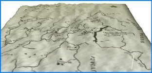
I wish you like this 3D image of Guaynopa from the old map you posted.

Regards

CACHILAN
 

Attachments

  • 3D Guaynopa-Herbert mapa 1884-fr.JPG
    3D Guaynopa-Herbert mapa 1884-fr.JPG
    28.5 KB · Views: 2,271
"The large canyon that I designated as the tayopa canyon in post # 22 iis actually the Barbaroccas canyon which empties into the rio Mayo at San luis Barbarrocos,"

Those pictures sure do remind me of the hike off Mount Lemon from the Boy scout camp area, south off the peak.? I'm sure you've seen the similar distinct mesa from Tucson. Never found treasure up that way, and digging would be a nightmare, but I did hit it for gold after the floods some ten years ago. No luck. Hope it works out better there!

? ? ? ? ? ? ? ? ? ? ? ? ? ? ? ? ? ? ? ?~~~~~~~~~~~~~~~~~

Hola? Johnstar:? I will be in Tucson most of Oct., perhaps we can meet` or talk on the telephone/computer??? I have an interesting story concerning "Window Peak". I will try to be at the hunt in the Freedom Park on the 1st. (5000 E 29 th).

I will be staying at my son's home? - 1962 W. Merlin rd.


Jose de La Mancha ( I itlt windmills )
 

Barbaroca canyon

Hi Jose de la Mancha:

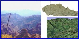
I wish you were doing well inTucson. There is a collage of your "Barbaroca canyon" picture with Topo and satellite images of that canyon with the correct orientation which signals Cerocho-Tayopa to the northwest bound to that mesa.

Why you think the "Father Villegas S.J. Derrotero" (Dobie's map) was not correct concerning the "Paramos" ?

Bye

CACHILAN
 

Attachments

  • Barbaroca canyon - V. Carranza, Chihuahua.JPG
    Barbaroca canyon - V. Carranza, Chihuahua.JPG
    28.7 KB · Views: 2,096
Helicopters in sierras

Hi Jose:

Just commenting you about helicopters in Chihuahua. I think it could be dangerous to fly over many canyons and deserted valleys in that state. It is said that when native people sees them they say: ?Ahi viene mucha pistola o mucha amapola? (flower). They mean, here comes a lot of guns or a lot of drug.

Last week the helicopter of the mexican ?Minister of Federal Public Security? had an accident when was flying over a Sierra in the ?Estado de mexico? not far from the capital city. He and all his top level staff died (8). Incidentally he was flying to the main security prison of ?La Palma?(Almoloya) to announce a new program for better control
of that place where are the main capos.

The impressive canyons you posted seems to be really dangerous to explore, they surely were old apache hidings or the lair or Pancho Villa when Gral. Pershing was hunting him in 1916.
 

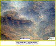
Here I am with another aerial picture of the Sierra Madre mineral tresures for the forum.
 

Attachments

  • Sierra Madre - Mexico- Mineral Treasures-JLLomeli.JPG
    Sierra Madre - Mexico- Mineral Treasures-JLLomeli.JPG
    58.5 KB · Views: 2,038
CACHILAN said:
Here I am with another aerial picture of the Sierra Madre mineral tresures for the forum.? ?

Hola Cachilan: That is a nice picture. Perhaps the viewers can now appreciate why it has been lost for almost 400 years, and what little help maps can be.

That is rough country, believe me. Now you can see why I easily spent many months in there on my mule, sometimes not meeting another person for a week at a time

You are on your own in that country.

You can also see why I am not too concerned about anyone else finding the Actual site of the Tayopa mines, or treasures., even if I told them where to look, heheheh.

Jose de La Mancha ( itlt windmills )
 

Top Member Reactions

Users who are viewing this thread

Back
Top