Jacob Waltz 160 acre 1/4 Section

Status
Not open for further replies.
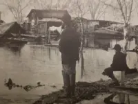
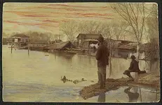
Thank you Matthew for the description of Waltz's place and the pictures of the flooded area from 1891. Pictures like these are probably the closes thing we will ever see as to how Waltz's home looked. It appears that the structures built out of wood or brick stood up much better to the flood waters that did the adobe structures which tended to melt away under the onslaught of the flood waters. Not trying to change the subject but you mentioned that Waltz supplied produce to Alex Steinegger's restaurants. Other than the Thomas' Ice Cream Parlor, do you know if he supplied produce to other businesses in Phoenix? I noted that there are a lot of trees growing in the two flood pictures. This may add credence to the story about Waltz climbing up a tree during the flood. Cordially, Gregory E. Davis
 

Thank you Matthew for the description of Waltz's place and the pictures of the flooded area from 1891. Pictures like these are probably the closes thing we will ever see as to how Waltz's home looked. It appears that the structures built out of wood or brick stood up much better to the flood waters that did the adobe structures which tended to melt away under the onslaught of the flood waters. Not trying to change the subject but you mentioned that Waltz supplied produce to Alex Steinegger's restaurants. Other than the Thomas' Ice Cream Parlor, do you know if he supplied produce to other businesses in Phoenix? I noted that there are a lot of trees growing in the two flood pictures. This may add credence to the story about Waltz climbing up a tree during the flood. Cordially, Gregory E. Davis


Hello Gregory,

The colorized postcard photos show the floodwaters as they were receding, the flood was considerably higher at it's peak. In the first photo you can see a house that has collapsed from the flood, possibly it was adobe and didn't stand up so well as the brick and lumber homes. Both Waltz and the Starrar homesteads were built up and around pretty well by 1891 with newer homes of wood construction. I also noted the trees in the area where once it was flat desert and fields. By 1891 farmers had planted windrows to keep the soil from blowing away.

My source for Waltz furnishing produce, eggs and milk to Alex Steinegger comes from Hilda Steinegger-Kramer, daughter of Alexander and Caroline Steinegger. Her mother Caroline was the sister of Emil Thomas. Emil Thomas was married to Julia Thomas. I think you knew Hilda and surely you must have known Victor her son. They lived just a few houses down on Fillmore and 7th street from your grandmother. Both houses are still standing and in fine shape.

Hilda's mother told her that Waltz was employed by her husband Alexander, and that Waltz would furnish fresh produce, milk and eggs to Steinegger's Hotel and restaurants in town. I believe Hilda said there were two restaurants or cafe's. Also Waltz furnished the same to Emil Thomas when he and Julia ran their bakeries and ice cream and oyster parlors. I don't know what Waltz's arrangement was with Julia once Emil had left town but Hilda said her father was not fond of Julia and had no more business arrangements with her once Emil was gone. Waltz may have supplied other establishments but that I am not sure of.

Matthew
 

Last edited:
enigma,

When I lay the physical street map of Phoenix over the 1900 tax assessors map it is off by one mile Meridian. (?)
The 1900 map was the only assessor legal description map I have to go by and I don't remember where that map came from or why I have that particular year. Now I am thinking it was in the Russell file because it was an error.
I'm trying to locate a later assessors map but cannot find one and will have to come to Arizona to get one. This could explain the confusion over the years. Waltz's homestead is physically where it has always been, it is the Legal Description that varies.

A while back I was asked to write an article on Waltz for the SMHS Journal and another one for Phoenix Magazine. I checked both of those articles and in both articles I place the Legal Description at NE 1/4 of Section 16 T1N. R3E. (?)
So I have gone both ways on this depending on which file I look at. (?)

Waltz's physical land remains the same, bounded on the North by Henshaw Road (Buckeye) on the East by 16th Street, on the West by 12th Street and on the South by the Salt river bottom. That does not change , only the legal description on paper.
I called the Maricopa County assessors office to give me the legal description of a property I own in Phoenix. From that I should be able to walk the sections down to south Phoenix and be sure.

Matthew
 

Last edited:
Phoenix flood 1891 .jpg Phoenix flood southeast of Phx. 1891.jpg


Side by side of the original photo of the 1891 Phoenix Flood and the colorized postcard made from it.

Matthew
 

I'm looking at my copy of the Phoenix 7.5' quadrangle (with revisions only to 1982, but that shouldn't matter when observing section lines).

Sec 16, T. 1 N., R. 3 E., is (roughly) bordered on the east and west by 16[SUP]th[/SUP] and 7[SUP]th[/SUP] Streets, on the north by Buckley (formerly Henshaw) Road, and on the south by an approximately located east-west line in the northern part of the Salt River floodplain. In other words, the area defined by the dashed black line in the accompanying scan.

Pima and Mohave Streets, the Post Office, and other landmarks being used in this thread to describe the location of the Waltz homestead are located not in the southeast quarter of Section 16, but in in the northeast quarter. The southeast quarter of the section lies (approximately) south of East Durango Street and east of 12[SUP]th[/SUP] Street.

So it does appear that the proper description for the Waltz homestead is NE ¼, sec. 16, T. 1 N., R. 3 E.

View attachment WALTZ LOCATION SEC 16.pdf
 

I'm looking at my copy of the Phoenix 7.5' quadrangle (with revisions only to 1982, but that shouldn't matter when observing section lines).

Sec 16, T. 1 N., R. 3 E., is (roughly) bordered on the east and west by 16[SUP]th[/SUP] and 7[SUP]th[/SUP] Streets, on the north by Buckley (formerly Henshaw) Road, and on the south by an approximately located east-west line in the northern part of the Salt River floodplain. In other words, the area defined by the dashed black line in the accompanying scan.

Pima and Mohave Streets, the Post Office, and other landmarks being used in this thread to describe the location of the Waltz homestead are located not in the southeast quarter of Section 16, but in in the northeast quarter. The southeast quarter of the section lies (approximately) south of East Durango Street and east of 12[SUP]th[/SUP] Street.

So it does appear that the proper description for the Waltz homestead is NE ¼, sec. 16, T. 1 N., R. 3 E.

View attachment 1004797


Thirsty44

That is what I am finding also and what I wrote in the SMHS and Phoenix Magazine articles NE 1/4 Sec 16 T1N. R3E.
The 1900 Maricopa County Tax assessor map which I have and have used in the past is one mile Meridian either N. or S. of the Baseline, basically one mile off. I'm still not sure which.


Matthew
 

according to "history of arizona" by farish volume 6, p 161 and 162

a meeting was finally called at the house of Mr. John Moore, which brought order out of chaos, and also brought forth the town of Phoenix, now the capital of Arizona. At this mass meeting of citizens of the valley, which was convened on the 24th of October, 1870, for the purpose of selecting a suitable spot of unoccupied land for a townsite, a committee was appointed to choose such a site. This committee was composed of Darrell Duppa, John Moore and Martin P. Griffin, all well known residents of the valley, and all of whom favored west Phoenix. After due deliberation the committee recommended the north one-half of section eight, township one north, range three east, as the most suitable location for a town, and that said town be called Phoenix

i dont know if that actually became the true location for the original townsite or not, but the records i see suggest it was
 

View attachment 1004769 View attachment 1004770


Side by side of the original photo of the 1891 Phoenix Flood and the colorized postcard made from it.

Matthew

the collection of photos in the herb and dorothy mclaughlin collection at asu is a real treasure trove of early photos like this one. its shocking that to my recollection nobody was reported killed in this flood considering the extent that the river flooded. newspaper reports of the flood are also very interesting to read
 

enigma,

Yes, I believe you are correct, that was the location. I called a friend who has researched and gathered all kinds of documents and records on Jacob Waltz. He told me he has a tax assessment from the 1870's showing Waltz on the SE 1/4 of Section 16. But also knew Waltz to be on the NE 1/4 also. Was Waltz involved with both 1/4 sections ? At the same time or in separate time periods ? His neighbor Andrew Starrar had that exact same set up, two 1/4 sections one above the other one. Exactly what time period was waltz on the NE 1/4 section ? That I cannot answer nor can I answer how long he was there. Very confusing and may take some time to sort out.

In the Judge Kibbey Salt River Valley Water Rights decision, Charles Roberts testified Jacob Waltz had the place (homestead) directly west of Frank Metzlers place (homestead). That would have put Waltz on the SE 1/4 of section 16. was Charles Roberts confused in his testimony or was Waltz actually on the SE 1/4 at some time ? Those 160 acre homesteads changed hands numerous times, one 1/4 section changed hands 11 times in 5 years. I think looking at one snapshot over a 23 year period does not give us the full picture. This may take some time to get the whole story.

Matthew
 

the collection of photos in the herb and dorothy mclaughlin collection at asu is a real treasure trove of early photos like this one. its shocking that to my recollection nobody was reported killed in this flood considering the extent that the river flooded. newspaper reports of the flood are also very interesting to read

enigma,

Herb and Dorothy McLaughlin have an amazing photo collection which took them decades to amass. They took many photos themselves.
Roscoe Wilson took the photos you see posted, Herb and Dorothy acquire copies of the photos from the Wilson estate.
Of all the photos in all the famous historians collections, someone else actually took those photos, the historians just collected them.
It is amazing no one was drowned in the 1891 flood.

Matthew
 

At least two persons I know were successful in locating the information on Waltz's intent to homestead records. I got my copy from one of them. It is not my personal copy so I cannot post it publically without permission. Several others have been given copies also. One of the individuals who found the record has since passed on.

one question, if the record of waltz filing an intent to homestead was in the public domain at one time which it must have been since it was a legal recording, what would cause it to be a private record now and not something free to be shared here or anywhere else such as the SMHS?
 

BTW Welcome to Treasurenet Enigma! Please do continue gentlemen (and ladies, whom do not seem to be posting at the moment).
Oroblanco

:coffee2: :coffee2: :coffee: :coffee2:
 

one question, if the record of waltz filing an intent to homestead was in the public domain at one time which it must have been since it was a legal recording, what would cause it to be a private record now and not something free to be shared here or anywhere else such as the SMHS?


Hello enigma,

I think you are misunderstanding me and/or projecting things onto me I did not say.

I never said the record was NOT in the public domain. I never said it was a private record now. I never said it was not something free to be shared here or anywhere else such as the SMHS.

What I said was an acquaintance of mine had found this record and shared it with me. I asked but was not told where it came from.
I was asked not to distribute copies of the record to others without permission. As I understand it anyone can access this record.

That's the long and short of it. You are asking questions of me that I have no control or responsibility for.

Matthew
 

Phoenix flood Starrar ranch .jpg

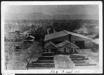
Here is a great photo of the great Phoenix flood of 1891.

The photo was taken from atop the tower at the Phoenix Fire Station at 1st Street and Jefferson looking south toward South Mountain and across the farms and homesteads just west of Jacob Waltz's 160 acres. The South mountains with telegraph pass can be seen in the distance.

The large building in the photo is Henry Ryder's lumber yard. The houses and trees in the floodwater directly behind the lumber yard are the houses and trees in the colorized photographs posted earlier in this thread.
If you look on the far left of the photo, just beyond the large house you see the western boundary of Jacob Starrar's 160 acres. This photo was taken after the floodwaters crested and began to receed.
A terrific photo which shows what the town of Phoenix and the homesteads south of town looked like in February 1891 while Jacob Waltz was still alive.

Matthew
 

Henshaw rd. and Central flood of 1891.jpg

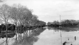
Another great photo of the Phoenix flood of 1891. Roger sent me this photograph and it looked familiar but I couldn't place it so sent it to a friend in Phoenix who works at the State archives.
She informed me it is Henshaw road looking west at Central Avenue. Henshaw road was the North boundary of Jacob Waltz's homestead. Today the road is known as Buckeye Road.
This is what Waltz's neighborhood looked like in February 1891.

Thanks Roger !

Matthew
 

Hello All: Year ago I made copies of the surviving Tax Records for Jacob Waltz. Available are the Tax Records plus the Assessment Rolls. Both are identical so I will only list the Tax Rolls except when only the assessment rolls are available. Not all of the years have survived. 1. Yavapai County Property Valuations Assessment Rolls, 1869, Jacob Waltz, 160 acres in the Salt River District. The rest are from Maricopa County, 2. 1872 Range 3E. 160 acres + Real Estate. The rest are all T1N, R3E. Section 16. 3. 1875 NE 1/4. 4. 1876, NE 1/4, 160 acres, 5. 1877, N1/2 of the NE 1/4. 6. 1878, NE 1/4. 7. The agreement between Jacob Waltz and Andrew Starrar in 1878 is for the NE 1/4 of Section 16, T1N, R3E. 8. The Land Title Records and Documents for Trans American Title and Trust Show his property to be the NE 1/4 of Section 16. T1N R3E. I cannot give a reason for some of the inconsistency of the quarter sections in 1877 other that the assessor or tax personal made a mistake in their recordings. I hope this listing will help and not confuse the issue. Cordially, Gregory E. Davis
 

P.S. Tomorrow I will post a copy of the Waltz affidavit from Book 1 of Misc. Page 107 that is missing. This is not the one that Matthew is talking about but a different one from the Milton Rose Collection. Rose was able to get a copy of it made by the county recorder clerk before the affidavit was torn from the book. Cordially, Gregory E. Davis
 

Hello enigma,

I think you are misunderstanding me and/or projecting things onto me I did not say.

I never said the record was NOT in the public domain. I never said it was a private record now. I never said it was not something free to be shared here or anywhere else such as the SMHS.

What I said was an acquaintance of mine had found this record and shared it with me. I asked but was not told where it came from.
I was asked not to distribute copies of the record to others without permission. As I understand it anyone can access this record.

That's the long and short of it. You are asking questions of me that I have no control or responsibility for.

Matthew

ive been out of pocket for the last day or two so didnt make time to respond until now and am sorry for the delay. alot of times its hard to convey the right meaning when the conversation is not in person. my question was more a rhetorical question than anything because i had read where you were asked not to share it and understood that since we all have been asked not to share things in the past and honored that request. from a historical standpoint waltzs claim would be a really interesting addition to the story of his life and its tough to imagine anything in there to lead to his gold mine. thats the only reason i asked the question i did in wondering why something like that wouldn't be made public, in fact why finding it wouldnt be something celebrated.

if its still out there in the public realm to be found im sure someone else will uncover it and share it. in doing searches for other documents and information back in the 1800s and earlier its not at all uncommon to find things misfiled. theres also always the possibility that at some point in time early on when those records werent controlled as well that they just disappeared for one reason or another into a private file.

i'll continue hoping that down the road some enthusiastic person will stumble across it and share it. Thank you for the response and also for the continued photos from the 1891 flood.
 

Hello All: Year ago I made copies of the surviving Tax Records for Jacob Waltz. Available are the Tax Records plus the Assessment Rolls. Both are identical so I will only list the Tax Rolls except when only the assessment rolls are available. Not all of the years have survived. 1. Yavapai County Property Valuations Assessment Rolls, 1869, Jacob Waltz, 160 acres in the Salt River District. The rest are from Maricopa County, 2. 1872 Range 3E. 160 acres + Real Estate. The rest are all T1N, R3E. Section 16. 3. 1875 NE 1/4. 4. 1876, NE 1/4, 160 acres, 5. 1877, N1/2 of the NE 1/4. 6. 1878, NE 1/4. 7. The agreement between Jacob Waltz and Andrew Starrar in 1878 is for the NE 1/4 of Section 16, T1N, R3E. 8. The Land Title Records and Documents for Trans American Title and Trust Show his property to be the NE 1/4 of Section 16. T1N R3E. I cannot give a reason for some of the inconsistency of the quarter sections in 1877 other that the assessor or tax personal made a mistake in their recordings. I hope this listing will help and not confuse the issue. Cordially, Gregory E. Davis


Gregory,

Thanks for posting the tax assessment recordings ! The tax assessors office was known to make errors. But also, the homesteads were so frequently changing hands in the 1868-1880 time period that anyone could have taken up a homestead anywhere at any time. You did not have to abandon or move off of one homestead to take up another one. Once the homestead had satisfied the requirements it was the property of the homesteader and could be sold, traded or shared. Five years was the time period for patenting a homestead so anytime after 1872 a farmer could have owned any number of patented homesteads or a parts thereof. Andrew Starrar had Two 160 acre quarter sections, one directly south of the one he lived on.

This now appears to be what has happened with Jacob Waltz. Waltz's original homestead and his adobe house were always on the NE quarter of Section 16. It is clear now that Waltz at one time had taken up the SE quarter of section 16 also. This does not mean Waltz gave up his original 1/4 section and moved to the SE quarter, it means for a time he was farming both quarter sections. How long he was farming the SE quarter is not known, it could have been years or a very short period of time. The property records would have to be gone through month by month to determine the length of time. His home in the census records would only show him at the 1/4 section where his dwelling was located.

The tax records of Maricopa and Yavapai county are a good resource but like all those Territorial records they are not complete. Waltz appears not to have paid taxes after 1879 but that was not the case. He was still on his NE 1/4 of sec 16 in 1891 when he was driven off by the flood. There is a lot more to the matter that meets the eye or is on the surface.

Thanks again Gregory.

Matthew
 

Status
Not open for further replies.

Top Member Reactions

Users who are viewing this thread

Latest Discussions

Back
Top