Is Gary Drayton right? Is there 1715 treasure in the Indian River?

Two guys sitting in a 2 holer out house. One guy hiked up his pants and as he did a quarter popped from his pocket and went right in the hole!! He promptly pulled out his wallet and tossed a !0 spot right in the hole. The other guy asked "What the heck you do that for!" The guy answered. " Cuz I ain't gonna climb down there for just a quarter.................

LOL. I was once digging a ghost town outhouse for bottles when I dug a half dollar. I always wonder if they person knew it was dropped and just decided it wasnt worth going after.
 

I won't even eat the fish I catch in the IR. Full of worms.

But I do eat the pompanos I catch from the beach. Surf fish are clean, but not the river fish.
 

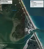
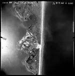
I noticed the circular area of water north of the inlet in 1945. Is that circular area what is used as the tidal swimming area today?
I've added some arrows to your image.

Nope. The circular area is still there, known as Campbell Pocket.
The Inlet has not moved since they blasted it open in 1918. It has shoaled in several times and was allowed to do so during WW2 so as to block entry to enemy vessels.

Here is a bit of the history of the Inlet: The History of Sebastian Inlet - Sebastian Inlet District (sitd.us)

From Wikipedia: Sebastian Inlet - Wikipedia


2020Inlet0.jpg
 

Then there is the mention by Kip Wagoner in Pieces of Eight a reference from the spanish archives that one ship tried to enter the St. Lucie Inlet (or maybe old Indian River or Jupiter inlet?) to escape the reefs.

Since the state owns river bottom and has the 50 year or older antiquities law, it cannot be achieved (unless found an a lease arranged? )
 

Last edited:
I noticed the circular area of water north of the inlet in 1945. Is that circular area what is used as the tidal swimming area today?
I've added some arrows to your image.

Nope. The circular area is still there, known as Campbell Pocket.
The Inlet has not moved since they blasted it open in 1918. It has shoaled in several times and was allowed to do so during WW2 so as to block entry to enemy vessels.

Here is a bit of the history of the Inlet: The History of Sebastian Inlet - Sebastian Inlet District (sitd.us)

From Wikipedia: Sebastian Inlet - Wikipedia


View attachment 1882374

Thanks Bill.
I'm pretty sure Campbell's Pocket is the area a river guide took my brother in law and me to catch bait for snook at the inlet during the red tide in 2018.

ps. That is a really clear image. I think I can see some silver on the bottom!
 

I noticed the circular area of water north of the inlet in 1945. Is that circular area what is used as the tidal swimming area today?
I've added some arrows to your image.

ps. In February I was talking to some construction workers at Boppy's about the road work they were working on this year by McClarty. He said the original plan of installing a 1/2" thick vinyl seawall on the river side (being installed to deter erosion) had to be reworked. The rocks/coquina/reef were only down about 7' and they could not drive the vinyl planks through it no matter what they tried. That is why they went to a formed and poured concrete one that seems to double as a sidewalk.
I don't know if it is tied to the underlying rock/reef with rebar, but I would imagine it has to be to keep from being undermined.

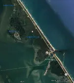
Notice in this attachment that the beach is a straight line where the red line intersects it. If you enlarge the attachment you will notice that south of this red line a ways there is a sandy area with a thin straight dark line running NW-SE, and the beach has a jog in it. Open current day google earth of the same area, notice that the north side of inlet sits further east than south side, not a straight line if you close the inlet. Also, on current day google earth, north of the inlet (where red line is in attachment) there is a pocket that resembles the pocket of 1945, google earth calls it Campbell Pocket. So I am thinking that todays inlet is south of the red line where the sandy area is in the 1945 arial. Just my 2 cents.
Sebastian Inlet.jpg

1945 Aerial Sebastian Inlet Closed.jpg
 

Notice in this attachment that the beach is a straight line where the red line intersects it. If you enlarge the attachment you will notice that south of this red line a ways there is a sandy area with a thin straight dark line running NW-SE, and the beach has a jog in it. Open current day google earth of the same area, notice that the north side of inlet sits further east than south side, not a straight line if you close the inlet. Also, on current day google earth, north of the inlet (where red line is in attachment) there is a pocket that resembles the pocket of 1945, google earth calls it Campbell Pocket. So I am thinking that todays inlet is south of the red line where the sandy area is in the 1945 arial. Just my 2 cents.
View attachment 1883129

View attachment 1883128

Disregard, I see Ropefish already pointed that out.
 

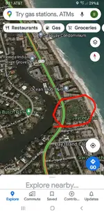
20201130_081627.jpg when I was a kid in vero the old timers used to say there was an inlet at Jaycee Beach park.....I herd that a few times from people in vero growing up....have no idea if thats true or not. Another big rumor growing up was that there was a whole wreck under the shoulder of A1A right in front of eckords/CVS at tracking station. Supposedly A1A workers hit it and just kept building road ??? If man wasn't here the whole coast would be different....only massive efforts by man have kept the coast somewhat stable and the same shape. Not sure if those stories were true or not but if the water ever breaches at jaycee Beach its a down hill rip to the river.....ther would be an inlet pretty quickly there if a storm ever breaches that spot.20201130_081831.jpg this pic shows the spot that A1A workers found a wreck of some sort ?? Any one else ever here rumors like this ??
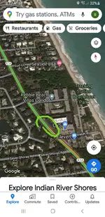
 

View attachment 1883144 when I was a kid in vero the old timers used to say there was an inlet at Jaycee Beach park.....I herd that a few times from people in vero growing up....have no idea if thats true or not. Another big rumor growing up was that there was a whole wreck under the shoulder of A1A right in front of eckords/CVS at tracking station. Supposedly A1A workers hit it and just kept building road ??? If man wasn't here the whole coast would be different....only massive efforts by man have kept the coast somewhat stable and the same shape. Not sure if those stories were true or not but if the water ever breaches at jaycee Beach its a down hill rip to the river.....ther would be an inlet pretty quickly there if a storm ever breaches that spot.View attachment 1883152 this pic shows the spot that A1A workers found a wreck of some sort ?? Any one else ever here rumors like this ??

I was detecting north of there yesterday with PetesPockets55, and he mentioned the same story about boat timbers under a building or street. As for an inlet at Jaycee, maybe someone can track down an old aerial of that area
 

Mrs. Langford was a looker !! Interesting history.
 

Another big fish kill in Indian River on the news this morning. Heading to the Glades for 2 weeks in mid Feb......Wilderness Waterway.........
 

Last edited:
The mangroves are right across the street from the beach on the east side of the river, maybe 200 yards. Completely possible wreckage was washed over the barrier island. It’s posted.....off limits. 100% agree with Bart. The river was the main highway back then. Check out Shipyard Island and Turtle Mound, the original Haulover Canal in Mosquito Lagoon at the North end of the river. This was the last stop to prep for the turn to the East. There is a possibility of the unfound wrecks being off Canaveral, also off limits.
Here are some pix of the ruins of the original Haulover Canal, the seawalls are the entrance on the Indian River side.View attachment 1866388View attachment 1866389View attachment 1866390
Can you or anyone tell me any more on mosquito lagoon? I have a piece of waterfront land there, thinking maybe it should be looked into.
 

$24,000 question: am I going to get busted hookah diving from a small boat with a metal detector in the Indian River?

I know it's not in the lease areas but "technically" it is illegal.
I’ve also been wondering as I’ve been wanting to myself. Did you find out?
 

View attachment 1883144 when I was a kid in vero the old timers used to say there was an inlet at Jaycee Beach park.....I herd that a few times from people in vero growing up....have no idea if thats true or not. Another big rumor growing up was that there was a whole wreck under the shoulder of A1A right in front of eckords/CVS at tracking station. Supposedly A1A workers hit it and just kept building road ??? If man wasn't here the whole coast would be different....only massive efforts by man have kept the coast somewhat stable and the same shape. Not sure if those stories were true or not but if the water ever breaches at jaycee Beach its a down hill rip to the river.....ther would be an inlet pretty quickly there if a storm ever breaches that spot.View attachment 1883152 this pic shows the spot that A1A workers found a wreck of some sort ?? Any one else ever here rumors like this ??
The rumor I heard put the vessel +-a block further south under a red(?) building, west side of A1A. The building was just remodeled early this year and I knew the contractor but couldn't connect with him to get a permission while work was going on.

The person (can't remember who now) that told me about it said he wanted to detect if that building ever came down. The building stayed up while being remodeled. Rats.

Bart, that river spot at Jaycee beach in your red circle is where the Bethel Creek house was located. A life saving station for wrecked mariners.
Here's a link for those that are interested.
Bethel Creek House
 

If you guys think there's no treasure on the riverside.....well you can just keep thinking that. Won't hurt any of the feelings of us that know better. You guys have not studied the lay out of the survivors camp or read the archie reports from the past. I can tell you that for long periods of time in the fall and winter you can't land a long boat on the shore ocean side. Imagine a 6-10 ored long boat trying to land on the beach in 6 ft. Surf. Remember the kings store house that was robbed by jennings......it was very close to the river not the beach. What about the water wells dug by the spanish ?? You guessed it closer to the river than the ocean. One is under the parking lot of the McLarty museum. Maybe the wreck didn't wash over the island but a tremendous amount of salvage activity happened on the river side. Most certainly long boats plied the riverside after entering the sebastion inlet. They would have used the river to load goods, treasure, survivors etc. The river was used extensively by the spanish during the salvage ops. Not to mention Indian tradeers and divers interacting with the spanish.....the river was then, what A1A is to us today. Coins have been found on the otheside of the river on the mainland that pre date the 1715 fleet. There are other wrecks on this coast that contained treasure and this area had seen seen shipwreck survivors for 100+ years before the 1715 event. So yes there is definitely 100% spots on the riverside that have treasure. Much of the good ground is protected but there are spots that can be hunted. People made great finds over the years on riverside properties. I believe the coins at bonsteel park show exactly what happens when you try to navigate an open boat on the ocean in heavy surf....you flip and lose the treasure again. The island is very thin at the salvage camp/muesum....the river is just a stones throw away from the dune crest !! How many times I've wanted to hunt the river in front of the museum....when i was in high school we would clam there and spanish pottery would come up in the clam rake.
Great post.
 

Can you or anyone tell me any more on mosquito lagoon? I have a piece of waterfront land there, thinking maybe it should be looked into.
All Mosquito Lagoon is part of Merritt Island Wildlife Refuge and is off limits to detecting
05ADAB57-7677-4836-8B31-6BCCC98F7C26.jpeg
C3D2F145-6DD6-4761-940F-C09F3E7409BD.jpeg
and is strictly enforced. On the East side of the Lagoon is the Canaveral National Seashore also off limits. Men in Black do a low level flyover around. 10:30 am. Lots of history there. Be careful and aware of huge wild hogs and gators, best way to explore is by shallow draft boat or kayak. IMO I would not go into the brush and mangroves without packing.
 

Last edited:
You can Hooka in the IRL, I wouldn't but that's me. As far as searching and keeping treasure I know nothing about that. The IRL is full of fish, many legal to spearfish for and a Hookah fits the bill. If you happen upon a treasure chest brimming with pearls, Gold, emralds, & more just swim on by with your Hawaiian slig and look for snapper.
 

Top Member Reactions

Users who are viewing this thread

Back
Top