Hi everyone -- now it is time to re-study the river design-
I have completed a google map with locations on where i have got my nuggets and smaller one, + specs
i uploaded some google view photos to give you an idea on how the terrain looks like, however, a couple of VERY important point to keep in mind:
1) on each side of the river there is some huge tall walls ( 8-10 meters) to control the river-
2) this is Taiwan --- we are hit by an average of 3 to 5 typhoons every year ( june to september maximum)
3) we do have earthquake in a daily basis ( less than 4.5 ---- it doesnt count for us)
4) all the gold from this part of the river comes from the mountain on the back ( which was mined 50 years ago)
5) during typhoon, and because of the walls, the level of the river rise by 6 -9 meters as it just filling up so basically gold will have a different path i guess
6) guys find nuggets in a weekly basis ( sniping, panning etc...)
7) configuration of this river change every time we have a heavy rain --- during typhoon season, you just cannot recognise the place anymore ( i mean boulders as big as rooms are moved without a pbm
so my question is: waz uppp!!!

nah, to be serious, how do you think gold travel in this kind of closed environment ( i means once flled with rain from typhoons)
PS= from A to B = around 500 meters ---- and B to C = 300 meters ===== 800 meters where there is gold all year long
Width of the river = 80 meters maximum from each side ( not wall to wall)
SMALL DESIGN

A

FIRST CURVE

INSIDE THE CURVE

END OF CURVE

B


")

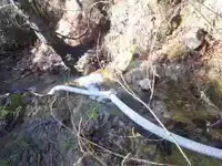
 I watched the video in the OP and, at 10+ foot of drop and 100' of hose, I have to ask why your water isn't coming out with more force. Would be great if we could have seen toe other end of the 100' run, where the water comes into the pipe. One thing that would have helped that a lot would have been to have a length of larger pipe/hose, like 4", then for the last 25' or so, switch back down to 3". The weight of the water in the 4" will help push more water through your 3", which should increase both your volume and pressure.


