French in Florida prior to Menendez

signumops

Hero Member
Feb 28, 2007
756
230
U.S.
Detector(s) used
Garrett, Minelab, Aqua-Pulse
Primary Interest:
All Treasure Hunting
I have access to this book written in Dutch around 1705 by Pieter Vander Aa dealing with the Huguenots (spelling?), particularly Laudoniere, Ribault, and a two other military folk of the period from 1564 - 1567. It was printed for Karl IX, and seeing how the Dutch and Flemish supported churches other than the Catholic church, I can only imagine what the tilt was toward the Spanish within the body of the text. Might be something we English speakers have not heard before.

At any rate, I am looking for somebody who can translate the text to English and I have excerpted a section of two galleys from one of the pages as a typical representation of the manuscript. It is old, of course, but still pretty legible. At the moment I am trying to do this on spec, hope to get some grant money to print and sell a finished translation, set side by side with the original images. Also will be a mongraph dealing with issues discussed by Vander Aa. This is definitely a publication Florida treasure hunters would find interesting (I think... don't know for sure till its translated, damn the bad luck!).

If you're interested, or know somebody who is, PM me. Or don't.
 

Attachments

  • VanderAA.jpg
    VanderAA.jpg
    224.7 KB · Views: 968
This may help a little.Jacques Le Moyne / Theodore de Bry, 1591
Brevis Narratio Eorum Quae in Florida Americae Provincia... M.D.XCI
 

Attachments

  • de-bry_le-moyne_titlepage-1591.jpg
    de-bry_le-moyne_titlepage-1591.jpg
    277.5 KB · Views: 1,010
AQUANUT HAD A DUTCH GUEST AT HIS HOUSE DURING THE PARTY BET HE CAN EASILY TRANSLATE IT FOR YOU :wink: :icon_thumright:
 

DeBry's illustrations were often fanciful, containing details that came straight out of his head.

Interesting project, Signumops. Best of luck with it.

Mariner
 

try wikipedia.org/wiki/jacques_le_Moyne and see if there is anything to your liking . Cornelius ( click on Jacques le Moyne )
 

Terry, try my friend shipwreck researcher Gaetan Algoet (he is also TH Forum member). He is always willing to help in this matter and the most important thing - Flamish is his native tongue!

Regards,
Lobo
 

This is the info i think you were looking for.René Goulaine de Laudonnière (c. 1529–1574) was a French Huguenot explorer and the founder of the French colony of Fort Caroline in what is now [Jacksonville, Florida]].But the Jacksonville area is wrong - don't ask me how they screw up so bad all the time or why they do....
 

The book is about 30 percent translated as I write this, thanks to Gaetan Algoet. He is making great progress so far. As I read his translation, I am particularly impressed with the extracts dealing with the Indians and the fact that there were some members of the French colonists who were becoming fluent in the native tongue.

Here is the translated title page...

Various Voyages to Florida by Pontius, Ribald, Laudronnerie, Gourgues

And others; occurring in the year 1562 and thereafter:

Concerning the strange encounters, morbid defeats, cruelties of all sorts, famine, treachery, disloyalties, and the escape of some Frenchmen from the hands of the Spaniards.

As well as detailed notes, regarding the opportunities of the land, religion, habits, lifestyle, warfare, flora, fauna, birds, fruits, wild plants and other interests.

Recorded by the travelers, and by them personally reported to his royal highness of France, Charles IX, and now from that language first translated.

Done at Leyden
By Pieter Vander AA, bookseller
With privileges


Close examination of the translated text reveals subtle clues of geographic descriptions we may have overlooked in the past. For example, Mexia, in his deraterro of 1605 describes great forests of Cedar, which are affirmed in this book as well. Cedars do grow in Florida, but are seldom, if ever, found in great stands as they are described in the Vander Aa book.

There is also a claim that in the area of Fort Caroline it was possible to capture lobster (presumably langousta) dragging nets in the sound of the river. That is the first impression. We'll have to pick it apart and compare notes with other affiliated historic material.

My initial interest in the subject matter is rooted in the final resting place of the Trinity (spelling?), which was probably in the vicinity of the Space Shuttle launch pad on the False Cape. More about that in the finished book. There are a number of locations along the Canaveral National Seashore that support this, in view of what has been found on shore by treasure hunters in years past.

As for Fort Caroline, yes, there seems to be confusion regarding its locale, but, I will look into it thoroughly to satisfy myself as this book is constructed.

We hope to produce a hardcover edition, in color, with maps, photos and exact reproductions of each page of the original manuscript.
 

fort caroline was in the st johns river * there is a woodcut print in a book done by the french attackers who came and "revenge killed" the spanish at what was known origionally as fort caroline * (after the first french slaughter by the spanish --the spanish took over the fort and spanish troops lived there until they were in turn wiped out a second french group sent to "revenge" the slaughter of the earlier first french group at fort caroline )--in the book detailing the account of the "revenge raid" there is a wood cut print showing fort caroline as a triangle shaped fort in mid river * (st john's river) sadly the site has been lost to the river over the years.
 

Ivan i know all the info printed today says it's in this location but i really don't think it's true.I have seen it on maps more than 1 map , in another location ..... was built on June 22, 1564. The fort was named for King Charles IX of France. ..
 

A really good book that deals with this exact subject is: Menendez, Captain General of the Sea by Albert Manucy (1983, St Augustine Historical Society)

Tom
 

RELICDUDE07 said:
Ivan i know all the info printed today says it's in this location but i really don't think it's true.I have seen it on maps more than 1 map , in another location ..... was built on June 22, 1564. The fort was named for King Charles IX of France. ..

All kinds of stuff shows up on maps; the question is are they in the right location on those maps?

Not many maps in those days were made according to the standards of the Coast & Geodetic Survey. Most were made in Europe from all kinds of sources, including information from illiterates and plagiarism.

I agree with Ivan about the location of Ft. Caroline, except I'm not sure that the Fort has been erased by the river. I've actually been to the site, and a lot of it is on private lands, and worse - some of it is on NPS lands. :laughing7:

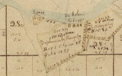
Here's an 1834 map of the area, with land owners names.

Ft Caroline 1834 small.jpg

I'll bet the Kingsley family could tell us a thing or two!
 

charles fort * was another fort built close to what is now known as "charleston" , south carolina * it was the first attempted settlement by the french (even before fort caroline - which was the second attempt ) charles fort * after failing to get resupplied was abandoned by the settlers , only a few which made it back alive (but only after eating some of their fellow settlers that died for food while on their return trip homeward in their "homemade boat" ) its tale is not a pretty one.
 

I look at a lot of maps .... When the place shows up again & again in the same location,i think it must have been close to that area......Fort Charle #13 Gulf of mexico
 

Attachments

  • hnoc_map27.gif
    hnoc_map27.gif
    178.2 KB · Views: 1,066
  • hnoc_map27.gif
    hnoc_map27.gif
    178.2 KB · Views: 1,024
In early 1562, Gaspard Coligny de Châtillon, the Admiral of France, dispatched the Norman mariner Jean Ribault to lead two royal ships and 150 men to survey the east coast of North America and locate a site for a future French colony. Landing near modern Jacksonville, Florida, Ribault established relations with a number of native peoples as he took his ships north to Port Royal Sound. Impressed by the apparent potential of this area for a colony, Ribault, before returning to France, left behind more than two dozen volunteers, who constructed a small wooden fort which they named after their king. From here they intended to explore the area while waiting for Ribault to return with supplies and more settlers.Hmmmmm
 

if worth anything, some note's, I saw ; there some kind settlement just north of the Main NPS
office, which is today: " Buck Island" and, pending which map, or map's... there where French sites
on just north Batten Island, and Fanning Island..

I'll bet the Kingsley family could tell us a thing or two! YES they can!!
 

RELICDUDE07 said:
I look at a lot of maps .... When the place shows up again & again in the same location,i think it must have been close to that area......Fort Charle #13 Gulf of mexico


The thing about the French is that they tend to repeat place names, Presque Isle and Grand Marais are good examples. There are a lot of them.
 

Top Member Reactions

Users who are viewing this thread

Latest Discussions

Back
Top