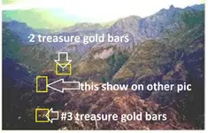
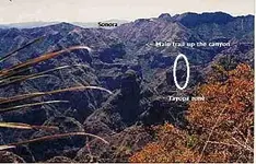
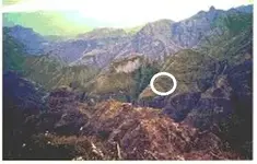
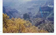
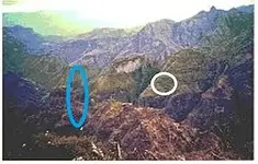
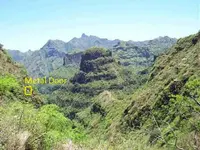
Interesting. I have dowsed for almost everything imaginable at one time or another. On topographical maps, I use a pendulum, depending on what the object(s) I am dowsing for determines which pendulum I use. Each one I have has its own definitive signature and ability. Most of the time I start with my master pendulum and then try to focus on a subtle hint as to what I have encountered. Then switching to a specialized pendulum to further determine the signature of the object. On your maps(google) or aerial, I normally use a pencil or my finger to get an overall feel for the region then try to decide on a specific target. On your last 2 maps there are multiple targets which tells me this area is heavily mineralized. Looks like an ancient volcanic eruption site. Red's methods are similar to mine in some respect as I learned mine from a professional treasure hunter and own several of his products, pendulums, L rods, and direction finders. Some use the bait method, others use a different concept, but all can be used by either method. Good luck. rockhound
You are using an out of date browser. It may not display this or other websites correctly.
You should upgrade or use an alternative browser.
You should upgrade or use an alternative browser.
Dowsing
- Thread starter chancey55
- Start date
aarthrj3811
Gold Member
- Joined
- Apr 1, 2004
- Messages
- 9,256
- Reaction score
- 1,176
- Golden Thread
- 0
- Location
- Northern Nevada
- Detector(s) used
- Dowsing Rods and a Ranger Tell Examiner
All the methods are interesting. I ask questions of the entire map. I then divide the map into fourths. I then ask the questions again. I then take the fourths which had yes answers and divide them into fourths. I keep doing this over and over. Just a process of elimination.....Art
[url]http://thunting.com/smf/index.php?PHPSESSID=826be5ce3ba089704aaf45a7886923b7&topic=329.0[/URL]
[url]http://thunting.com/smf/index.php?PHPSESSID=826be5ce3ba089704aaf45a7886923b7&topic=329.0[/URL]
Last edited:
TrueBlueL.
Jr. Member
- Joined
- Oct 12, 2015
- Messages
- 34
- Reaction score
- 18
- Golden Thread
- 0
- Primary Interest:
- All Treasure Hunting
Excuse my ignorance, but I'm curious to know if this dowsing requires invoking spirits or any kind of spirituality?
Last edited:
aarthrj3811
Gold Member
- Joined
- Apr 1, 2004
- Messages
- 9,256
- Reaction score
- 1,176
- Golden Thread
- 0
- Location
- Northern Nevada
- Detector(s) used
- Dowsing Rods and a Ranger Tell Examiner
no it does not
okiedowser
Hero Member
Real de Tayopa Tropical Tramp
Gold Member
- Joined
- Nov 8, 2004
- Messages
- 14,582
- Reaction score
- 11,947
- Golden Thread
- 0
- Location
- Alamos,Sonora,Mexico
- Primary Interest:
- All Treasure Hunting
Rockhound, you are using Don Harris' method almost exactly, he was very good also.
Real de Tayopa Tropical Tramp
Gold Member
- Joined
- Nov 8, 2004
- Messages
- 14,582
- Reaction score
- 11,947
- Golden Thread
- 0
- Location
- Alamos,Sonora,Mexico
- Primary Interest:
- All Treasure Hunting
AArthur, I agree, no spirits, you don't need them or any outside help.
Real de Tayopa Tropical Tramp
Gold Member
- Joined
- Nov 8, 2004
- Messages
- 14,582
- Reaction score
- 11,947
- Golden Thread
- 0
- Location
- Alamos,Sonora,Mexico
- Primary Interest:
- All Treasure Hunting
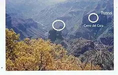
Okiedowser, you are on also. in yoour lower picture, the hill in the background " The cero del Cura" we found a series of tunnels, but nothing in them  We found them by a pair of Macaws flying into one for their nesting.
 We found them by a pair of Macaws flying into one for their nesting.
okiedowser
Hero Member
Okiedowser, you are on also. in yoour lower picture, the hill in the background " The cero del Cura" we found a series of tunnels, but nothing in themWe found them by a pair of Macaws flying into one for their nesting.
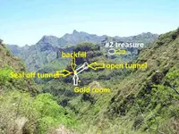
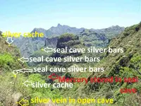
Well you get some closer picture's of it ,and i show you where its at,because its there,100% on that.it will be sealed off,and there will be a open tunnel leading into it,i have not found one yet that was not sealed off.....but they always put a way into it,because they want air on it,where it don't build up gases,from the mercury,that will kill you(if it been sealed up for a long time without air),gold bars is easy to find,by dowsing for mercury the bars has about 1 percent left in them.
teleprospector
Silver Member
- Joined
- Jul 8, 2007
- Messages
- 3,965
- Reaction score
- 4,242
- Golden Thread
- 0
- Location
- The Motor City
- 🏆 Honorable Mentions:
- 25
- Detector(s) used
- Extended Sensory Perception, L-rod, Y-rod, pendulum, angle rods, wand.
White's MXT, Garrett Ultra GTA 500, AT Gold, SCUBA Detector Pro Headhunter, Tesoro Sidewinder, Stingray, 2 box-TF900, Fisher TW-6
- Primary Interest:
- All Treasure Hunting
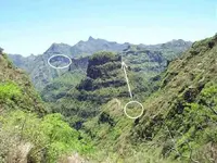
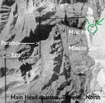
Hello Real de Tayopa Tropical Tramp,Dowsing revealed an attraction to gold in all your pictures indicated by the white/green circled areas. I also included arrows/line indication where dowsing revealed attraction to energy lines of the gold.Thanks for posting your pictures,Jon
Attachments
Last edited:
prospecter77
Jr. Member
- Joined
- Sep 9, 2015
- Messages
- 72
- Reaction score
- 160
- Golden Thread
- 0
- Location
- Durango , Colorado
- Detector(s) used
- Garrett
- Primary Interest:
- All Treasure Hunting
Loved this Quote , 
 and Eggnog for all .

 and Eggnog for all .
and AMEN !!Hello Real de Tayopa Tropical Tramp,Dowsing revealed an attraction to gold in all your pictures indicated by the white/green circled areas. I also included arrpws indication where dowsing revealed attraction to energy lines of the gold.Thanks for posting your pictures,Jon
Last edited:
Real de Tayopa Tropical Tramp
Gold Member
- Joined
- Nov 8, 2004
- Messages
- 14,582
- Reaction score
- 11,947
- Golden Thread
- 0
- Location
- Alamos,Sonora,Mexico
- Primary Interest:
- All Treasure Hunting
Gentlemen, I posted te pictures for you to practice with since we can previously verify the existance in most cases
You may like to know that you are darn good.
You may like to know that you are darn good.
Last edited:
Real de Tayopa Tropical Tramp
Gold Member
- Joined
- Nov 8, 2004
- Messages
- 14,582
- Reaction score
- 11,947
- Golden Thread
- 0
- Location
- Alamos,Sonora,Mexico
- Primary Interest:
- All Treasure Hunting
Gentle men, now try for siler, Tayopa was famous for it's richness in Silver
I have the concesion forTayopa, so I can confirm if you are correct.


I have the concesion forTayopa, so I can confirm if you are correct.


Last edited:
My first encounter with dowsing came from a local man(part native American) which was brought to find water for digging a well. I was young then, maybe 10. I watched with curiosity as he found the underground spring, yes that what it turned out to be. Fast forward about 10 years and I found myself accompanying my brother-In-law on a treasure hunt with a cheap metal detector he had purchased from a flee market. It further got my curiosity aroused and I began to read all about treasure hunting from Lost Treasure and other magazines at the time. In one I found an ad close to my location of a man who made and sold L rods and LRD's. Long story short, I called him and had a nice conversation on the phone and ordered one of his L rods. His name was Fred Stewart, a professor at a local college that did this as a hobby. He taught me almost everything I know about dowsing. And his instruments are top notch from what I have used. I sometimes experiment to see what will work and what won't, and in the process have discovered some interesting things about dowsing and myself. Good luck. rockhound
okiedowser
Hero Member
Real de Tayopa Tropical Tramp
Gold Member
- Joined
- Nov 8, 2004
- Messages
- 14,582
- Reaction score
- 11,947
- Golden Thread
- 0
- Location
- Alamos,Sonora,Mexico
- Primary Interest:
- All Treasure Hunting
okiedowser
Hero Member
Okie dowser your are damn close It is a cave with a griled door and padalock Upper three indications. Ya earned your coffee.
Y View attachment 1252453
Thank's for the coffee...he he...yes its hard to look at a picture that you dowse,and move all your mark's to the one you are sending,i would scan it but i don't use color ink,just black ink,you don't alway's get them mark's
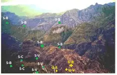 where you want them....unless you are working with a Gps where you can get real close when you mark it.
teleprospector
Silver Member
- Joined
- Jul 8, 2007
- Messages
- 3,965
- Reaction score
- 4,242
- Golden Thread
- 0
- Location
- The Motor City
- 🏆 Honorable Mentions:
- 25
- Detector(s) used
- Extended Sensory Perception, L-rod, Y-rod, pendulum, angle rods, wand.
White's MXT, Garrett Ultra GTA 500, AT Gold, SCUBA Detector Pro Headhunter, Tesoro Sidewinder, Stingray, 2 box-TF900, Fisher TW-6
- Primary Interest:
- All Treasure Hunting
okiedowser
Hero Member
Similar threads
Users who are viewing this thread
Total: 1 (members: 0, guests: 1)


