Could there be Pyramids in Texas?

irbaddadjoe

Sr. Member
Joined
Sep 9, 2006
Messages
488
Reaction score
8
Golden Thread
0
Location
Bridgeport, Texas
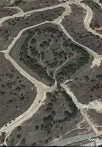
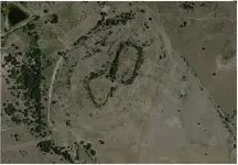
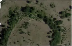
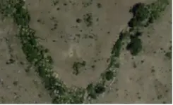
About 20 years ago while working part time for a moving company we where loading the trucks when I noticed a large hand drawn map hanging on the wall of a lady we were helping to move. When I asked her about it she said it was a map of a cave system on a mountain behind the house that her father had spent his life mapping. Being young I remember thinking that had to be a huge cave. She said her father never did finish mapping it before he died. Anyway years have passed and I never did hear anything else about this hill and figured if there was something there it would be front page news. Although everytime I have ever passed I would look at this hill and wonder and think something just looks different about this place. Well I was messing around with some of the new aerial imagery we have nowadays and remembered this place and thought I would have a look. Now I am really fascinated with this place. The appearance of the rocks seem very much man made. I thought it might be worth a post. Dare we wonder?
 

Attachments

  • cavern.webp
    cavern.webp
    37.3 KB · Views: 2,318
  • cavern2.webp
    cavern2.webp
    16.4 KB · Views: 1,888
  • cavern3.webp
    cavern3.webp
    16.4 KB · Views: 1,737
  • cavern4.webp
    cavern4.webp
    19.8 KB · Views: 1,703
Upvote 0
Some new ideas to this location. While reading about some other finds in the state i came across stories of the star rock and spider rocks. I couldnt help but notice how much these symbols looked like this place. The star rock shows the 8 that looks like this mountain top. The spider rock looks just like the vegetation lines north of the mountain. I decided to follow the stream that is at the base of this mountain. It opened into the brazos river at a place called Coronados camp. At the opening from google it looks like a earth mound shaped like an arrow pointing to a stick figure. Just some new interesting thoughts about this place.IMG_8431.webpIMG_8403.webpIMG_8422.webpIMG_8399.webp
 

Upvote 0
So who you think planted the trees?
 

Upvote 0
sitting at my desk eating some Wendy's chili and currently about 5 or 6 miles from one of the site on the map above of the Mississippian Mound Builders. (Winterville Mounds) Here is an ariel pic of that sitewinterville.webp..another closer, winterville2.webp
 

Upvote 0
40 miles to north of Winterville is Yazoo National Refuge that I used to manage land and had to go through this VERY LIGHTLY traveled place to get to some farm land we had. I ran across this place in the middle of the place...the bunch of trees in the triangle is the mound. Just noticed the clearing was triangle shape now. All this just to give a reference what the Mississippian mounds look like here from the sky...btw, these things are ancient. The mound builders thrived from 1000 AD to 1450 AD...so, if mound builders site, its old :)

swanisland.webp
 

Last edited:
Upvote 0
I think it is a native american mound builder temple thing though it could be natural Very cool!
 

Upvote 0
Some historians have claimed old records exist that were written by those that dug out some mounds and found giant 8 foot tall men's bones in them too.
 

Upvote 0

Top Member Reactions

Users who are viewing this thread

Back
Top Bottom