Cornfield arrowhead hunting

Vinland

Tenderfoot
Oct 28, 2023
9
20
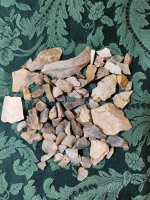
I'm kind of new to searching fields. I've pretty much just searched creeks and rivers forever. I'm having a little luck in cut cornfields after it rains. I'm coming across certain areas in a couple harvested cornfields and soybean fields. All of these fields run up hill from a creek. I'm finding debitage pretty heavy in certain areas on all the fields. Other areas absolutely none. Should I concentrate on the areas where I'm finding chert and flint or the whole fields.
 

Upvote 2
Encampments were often on high ground near water

Most of my field finds I think were just lost in hunting
 

As a rule, if looking at a topographical map of your area(s), the first "line" up from the water is where to start. If you are finding chert / flint in any field. Keep looking there. If widely scattered, work to locate areas with more than less....go with more.

Water ways have moved over eons so do not think in terms of today's view of things....imagine where it WAS as well and think outside the box. They HAD to stay near water and HAD to camp above the expected flood stage.

Do not discount any creek areas as we have areas where you can see campfire rings on top of campfire rings in the
sides of the banks of our creeks.


A sample:
(f.y.i. I have found help by looking at OLD topos like the example)


IMG_4593.jpeg

vfm
 

Last edited:
Congrats on what sounds like a great site to explore. I like to work the areas with the most visible flakes first and to revisit them after every hard rain.
Any pictures of your debitage finds?
 

Debitage is great but once the NA knapped a point, wether an arrowhead, knife, or spear he walked away & used it elsewhere. In my experience, debitage never resulted in points being found. It does show that it was an area used and lived in by early people's.
 

I'm kind of new to searching fields. I've pretty much just searched creeks and rivers foreve...Should I concentrate on the areas where I'm finding chert and flint or the whole fields.
tn_moved_over.gif
I moved ya from HELP! over to NORTH AMERICAN INDIAN ARTIFACTS for more exposure.
tn_notice.gif
NOTE: Forum HELP! contains guides tutorials on how to use the new TreasureNet.com software.
 

Well if you are a water hunter fields should be easy. When you are walking the creek below the field there should be sections where you have found more artifacts in the creek more than other sections usually right after a bend. What I would do is focus above those sections but in the fields and see if you can locate the campsites. I’ve found points along with debitage in fields but mostly preforms. From what I’ve seen the debitage piles is discarded material that is placed away from the campsite like in a trash pit. Go above the piles I would think the trash pits would be below the campsite so they wouldn’t step on the raw chips. If you add pictures of the field you are looking on make sure you leave any landmarks out so nobody will know where you are looking.
 

Well if you are a water hunter fields should be easy. When you are walking the creek below the field there should be sections where you have found more artifacts in the creek more than other sections usually right after a bend. What I would do is focus above those sections but in the fields and see if you can locate the campsites. I’ve found points along with debitage in fields but mostly preforms. From what I’ve seen the debitage piles is discarded material that is placed away from the campsite like in a trash pit. Go above the piles I would think the trash pits would be below the campsite so they wouldn’t step on the raw chips. If you add pictures of the field you are looking on make sure you leave any landmarks out so nobody will know where you are looking.
The creek below the cornfields I'm not familiar with it like I am the rest around the area. The fields holding all of the debitage are on the western slope of a higher hill. The hill sits about the exact center between two creeks. What's strange is that I've walked the field on the eastern slope several times and I haven't seen one piece of debitage. Nothing. Not one piece. I've been on my knees looking through washouts in this field. Do you have any idea why? This isn't an area any bigger than about eighty acres. I'm just trying to figure out how to read fields. I appreciate your post. This is what I'm looking at in the cornfields. There's areas that are covered and areas almost nothing.
20231027_151308.jpg
 

Well if you are a water hunter fields should be easy. When you are walking the creek below the field there should be sections where you have found more artifacts in the creek more than other sections usually right after a bend. What I would do is focus above those sections but in the fields and see if you can locate the campsites. I’ve found points along with debitage in fields but mostly preforms. From what I’ve seen the debitage piles is discarded material that is placed away from the campsite like in a trash pit. Go above the piles I would think the trash pits would be below the campsite so they wouldn’t step on the raw chips. If you add pictures of the field you are looking on make sure you leave any landmarks out so nobody will know where you are
Well if you are a water hunter fields should be easy. When you are walking the creek below the field there should be sections where you have found more artifacts in the creek more than other sections usually right after a bend. What I would do is focus above those sections but in the fields and see if you can locate the campsites. I’ve found points along with debitage in fields but mostly preforms. From what I’ve seen the debitage piles is discarded material that is placed away from the campsite like in a trash pit. Go above the piles I would think the trash pits would be below the campsite so they wouldn’t step on the raw chips. If you add pictures of the field you are looking on make sure you leave any landmarks out so nobody will know where you are looking.
I failed to mention that the field on the east side of the hill is also tilled. I have spent a lot of time checking it after a couple of heavy rains. I haven't seen one piece of anything on this field.
 

Congrats on what sounds like a great site to explore. I like to work the areas with the most visible flakes first and to revisit them after every hard rain.
Any pictures of your debitage finds?

Congrats on what sounds like a great site to explore. I like to work the areas with the most visible flakes first and to revisit them after every hard rain.
Any pictures of your debitage finds?
This is a picture of some random pieces along with a broken point I picked up yesterday morning.
20231029_063849.jpg
 

Attachments

  • 20231029_063849.jpg
    20231029_063849.jpg
    3.3 MB · Views: 10
As a rule, if looking at a topographical map of your area(s), the first "line" up from the water is where to start. If you are finding chert / flint in any field. Keep looking there. If widely scattered, work to locate areas with more than less....go with more.

Water ways have moved over eons so do not think in terms of today's view of things....imagine where it WAS as well and think outside the box. They HAD to stay near water and HAD to camp above the expected flood stage.

Do not discount any creek areas as we have areas where you can see campfire rings on top of campfire rings in the
sides of the banks of our creeks.


A sample:
(f.y.i. I have found help by looking at OLD topos like the example)


View attachment 2112159

vfm
I used the topoView site and found a map from 1885. It was very useful because there was a spot I suspected used to be a spring. The old locals I know around here weren't sure about it. Well it shows up on the map I printed off. I appreciate the information. Thanks
 

A lot of decent flint in there. I hope you keep finding more. 👍🏼
 

The creek below the cornfields I'm not familiar with it like I am the rest around the area. The fields holding all of the debitage are on the western slope of a higher hill. The hill sits about the exact center between two creeks. What's strange is that I've walked the field on the eastern slope several times and I haven't seen one piece of debitage. Nothing. Not one piece. I've been on my knees looking through washouts in this field. Do you have any idea why? This isn't an area any bigger than about eighty acres. I'm just trying to figure out how to read fields. I appreciate your post. This is what I'm looking at in the cornfields. There's areas that are covered and areas almost nothing. View attachment 2112299
That is quite a saturation of flint! I’ve been finding a lot too, but mine is not concentrated in any area as heavily as yours. That looks very promising.
 

That is quite a saturation of flint! I’ve been finding a lot too, but mine is not concentrated in any area as heavily as yours. That looks very promising.
It's been so dry here the farmers haven't turned their fields yet so I've been walking pretty much nine month pack. We finally got about five inches of rain in the last week so they should start turning them about any time. I expect I'll get a whole new view when they're turned and hopefully some more rain.
 

It's been so dry here the farmers haven't turned their fields yet so I've been walking pretty much nine month pack. We finally got about five inches of rain in the last week so they should start turning them about any time. I expect I'll get a whole new view when they're turned and hopefully some more rain.
Gather what you want to save before the disc shows up. I know most folks like tools better than flakes; I do too. But I still see them all as part of the area’s history.
 

Next time you are out there see which side of the hill the sun sets on. It could tell you if it was a winter camp or a summer camp. In the winter they would camp on the side of the hill that got the most sun. Summer the opposite side. Sounds like the camp should be above the material you are finding. I’ve walked many fields. One field there is levels of fields.
1st level there is a spring that empties into a good size creek really close to the spring. I find Adena and Early Woodland there.
2nd level I find Woodland to Mississippian.
3rd level the highest of the fields I’ve found Dalton to Early Archaic. Kirks for an example.
One thing most people don’t realize is that the water level has risen and fallen over the years. So that creek at one time in the early years might have been as big as a river. That’s just one example for you. Here is a frame of some of my finds. The tiny ones across the top are 1/2 or smaller. In that flake debris you are finding anything triangular flip even the tiny ones. If it’s worked on both sides it might be a point. Good Luck
 

Attachments

  • IMG_0138.jpeg
    IMG_0138.jpeg
    229.4 KB · Views: 23
I 100% agree with this. Our farm has a half dozen or more dry springs. So far, the one's I have checked had lots of chert and quartzite in the dry spring all the way down the hill. Gotta get those leaves out of the way....great information.

One thing most people don’t realize is that the water level has risen and fallen over the years. So that creek at one time in the early years might have been as big as a river. That’s just one example for you. Here is a frame of some of my finds. The tiny ones across the top are 1/2 or smaller. In that flake debris you are finding anything triangular flip even the tiny ones. If it’s worked on both sides it might be a point. Good Luck
 

Congrats on what sounds like a great site to explore. I like to work the areas with the most visible flakes first and to revisit them after every hard rain.
Any pictures of your debitage finds?
I picked this up this morning. I'm noticing the higher I get the bigger the pieces are. Obviously. I froze this morning. I went early to search with a light.
20231029_195541.jpg
 

Top Member Reactions

Users who are viewing this thread

Back
Top