Coopers Treasures

Interesting link Bum Luck. Doesn't Miklos say the pictures were taken from an experimental camera mounted in the nose ? "If" it was taken from a nose mounted camera then how would Miklos be allowed to have access to it I wonder. That would be Government property I thought. Some things are not making sense, of course that is reality t.v. for you.
 

Sounds like your avatar dog is sniffing that out.

I think he also said it was on a tether.

The size of the Hycon-73b is greater than the size of the capsule nose, and experimental notwithstanding, was state of the art.

Also this: Cooper was writing lat/lon coordinates on targets on the earth. That statement is ludicrous for 1963. Especially tumbling in flight as he was.

Bottom line is Miklos is selling a wild story to a populace to whom critical thinking skills are in short supply.

I don't see why the Hysterical Channel doesn't fund a search and salvage of Ivan's wreck in Nassau Sound instead of this guy who your dog would probably bite.


In 1960 President Kennedy bragged that we have the technology to see a lisence plate on a car in Moscow. That was 58 years ago. What do you think we have now?

He might have been pulling Nikita's leg a bit, but he didn't say they could read it, just see it. That's a foot, not 2 1/2.

I don't know how good it is now, but remote sensing is an inverse exponential business; that is, a lot of progress has to be made to gain a small return. We are doing that, of course. So the answer is, a lot better.
 

In 1960 President Kennedy bragged that we have the technology to see a lisence plate on a car in Moscow. That was 58 years ago. What do you think we have now?

===========
55 years ago, would he be able to see under sand which was under water ?
 

===========
55 years ago, would he be able to see under sand which was under water ?

From space? Har!

Seeing gullibles now Matey, that's a different thing.
 

I am not a believer in it, ( pinpoint pictures from outer space 55 years ago ).
I was sort of surprised when they pulled out their underwater LIDAR, but wasn't impressed with the results.
 

Last edited:
I am not a believer in it, ( pinpoint pictures from outer space 55 years ago ). [ /QUOTE]
The orbit varied from 88 nautical miles to 143 nm. So, imagine the difficulty of seeing a dog house at that distance.
 

i have seen some pretty cool pictures taken from space,but they where from a sr-71 blackbird.but i think the show is bs.
brad
 

==========
Thanks ropesfish, now it makes more sense to me. Salvor6's information makes some sense as well, yet I wonder why back an expedition that can only look but don't touch ? ( Which this offers an explanation into the "alleged" Columbus anchor which they had to put back. In order to save face with the viewers he blamed this on a rival. )

The value of a hit TV show like "Deadliest Catch" outweighs the value of most wrecks by a good margin and that is where the value is to the TV folks, but if I find a wreck today for the TV show, I still have the GPS numbers on where to find it if permits are ever to be had. Jim, Mike and Eric make a nice chunk of change and get to do cool stuff on NEW equipment and boy...that's unusual in this business.
I agree that the premise is scientifically unlikely and that the drama quotient is too high for my tastes but it has been getting 800,000 to 900,000 households to watch according to Nielsen...by comparison NCIS reruns get 12,000,000 , Deadliest Catch 3,000,000 and any news show on Fox gets 3,000,000.
I don't remember who it was that found that big anchor in the Turks the first time, but that was a known anchor for 30+ years. Someone posted pictures on the Atocha Golden Crew Facebook group of that anchor being on the deck of a barge back in the 70's or 80's. As I recall, the gendarmes were on their way to revoke their salvage permit so the anchor was put back on the seafloor to await the arrival of the Miklos crew decades later. The pictures were taken down from Facebook fairly quickly. I suspect there was some question as to the statute of limitations or something.
It's a show. I'm glad some friends are making a few bucks on the deal. Do I think it represents treasure salvage well...not really, but if you Fast Forward through the drama and just watch the crew work, it beats watching Wheel of Fortune.
 

Oh, now come on, you naysayers. Half of you live on the Treasure Coast that overlaps the Space Coast! THAT'S COOL! Who cares if Gordo's mission was just a 1960s version of Google Earth? It's treasure hunting from space, involving a real astronaut & bona-fide treasure hunters! Bet you wish you'd thought of that for a TV show idea! I know I do.
 

Being interested in remote sensing for decades, I found the main premise for the show far fetched, to say the least. Turns out I'm not alone. I found the show reviewed by The Space Review:
The Space Review: The magic MacGuffin of Mercury 9

Here's part of it:
Specifically, reports Miklos, Cooper told him he found the potential treasure spots using a secret military sensor that had been installed on the spacecraft originally to hunt for Soviet nuclear missile bases hidden in the area of Cuba–where a major international crisis involving such missiles had occurred only a few months before the flight.

“They were utilizing some kind of long-range detection equipment to look for nuclear threats,” Miklos told Fox News. “With that, his acute vision [and] possible cameras, he started identifying things that looked like shipwreck material. Once he had written all the coordinates down, he went back to Earth and put together this incredible treasure map from space on a sea chart."

And it’s not as if Cooper was crisscrossing Caribbean skies sightseeing. If the show is claiming that Cooper photographed the whole Caribbean area, it doesn't jibe with the actual flight path of the mission. Cooper only passed across the northern edge of the sunlit Caribbean on his fourth and 20th orbits (and a south pass Cozumel to Maracaibo on orbits 5 and 21.) He was busy with other stuff—as shown on the transcripts—on both the fourth and fifth orbits, when he explicitly described himself viewing the northern horizon, not nadir ground landmarks, and was doing deorbit preparations on the 20th and 21st orbits.

In the bigger picture, any pressing justification for the alleged capability the device exclusively offered is also impossible to find. The spacecraft only orbited between 32 degrees latitude north and south, and all that airspace was fully-accessible to heavily instrumented airborne sensors already in the US inventory. Highly-capable US military spacecraft were routinely flying in orbit, able to carry such sensor systems, if they even existed. No Soviet nuclear missile sites in that near-equatorial band were ever found by any means.

Flight transcript shows Cooper took 29 photos, not 5,245, which would have been mathematically impossible, not to mention that the capsule wasn't always pointed at the ground.

Choking yet? Read the whole review. And the comments, some by ex-NASA vets.

I love a treasure story (real ones preferred) as well as anyone, but this one careens from the preposterous to the absurd with Miklos scrambling from Spanish treasure to Sir Francis Drake to keep himself on the water, and presumably to contract. Hopefully, some vice president is in trouble for signing Miklos.


Last edited:
Who knows what resolution orbiting platforms Had back then,or have now. Hell, they denied the existence of area 51 groom lake for How many Decades ?
 

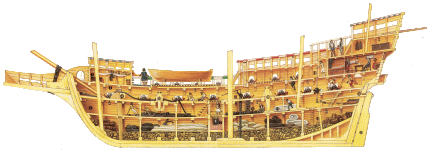
But can't a Ship Drop their Ballast in order to Get higher & avoid Wrecking ?
Making some of The Ballast Completely useless for Wreck finding.

I guess lightening the load for a storm or to get higher the ballast would not be in a pile?
RTR, looking at buoyancy, you cant really look at the size of the ballast pile vs amount of gold, as they had different loading considerations, or you would find the gold with the ballast.

A large ballast pile could be a sign of a shipwreck, again just curious how one would use a mag to locate a ballast pile?
 

though I was guessing,

I took it to mean ballast Piles from Many Wrecks. Piled on top of each other.

But can't a Ship Drop their Ballast in order to Get higher & avoid Wrecking ?
Making some of The Ballast Completely useless for Wreck finding.
If they were dropping ballast wouldn't it be scattered from throwing the rocks overboard versus a pile in the shape of a ship hull?
 

If they were dropping ballast wouldn't it be scattered from throwing the rocks overboard versus a pile in the shape of a ship hull?

yea makes sense.

I was thinking They may have a way of Opening the Bottom Long enough To Drop the ballest,
and till stay Dry. Like putting a Jar upside Down in Water :unhappysmiley:
I don't know much about Ships. ???
 

Who knows what resolution orbiting platforms Had back then,or have now. Hell, they denied the existence of area 51 groom lake for How many Decades ?

The "orbiting platform" we had back then is a very exact historical fact - a Mercury space capsule still on display at the NASA museum in Houston.

I covered the resolution issue above, and there were no decent recon cameras aboard as they were way too heavy and bulky. Also no real provision to even point the capsule in the right direction.

Also there's no reason to take photos of the Bahamas with a 35mm camera from 84 nm up when you can take large format film from 2000 feet up if you want. That is an improvement by a factor of 250. That would get resolution of fractions of an inch - but there are no such pictures since there's no strategic value there.

NASA photos have been declassified for decades now.
 

Last edited:
The only way you are going to see anything on the bottom of the ocean in shallow water shooting with a 35mm film camera is to use kodak color infrared film using 10 to 15 different color filters will allow you to see live and dead coral growth on reefs and man made objects.When i lived in hawaii i went to the university of hawaii and majored in oceanography.we had to do reef studies.While everyone in my class was swimming around on the reefs i got my dad to fly over the reefs and i shot all the reefs in kailua bay with IR color film.I even found several sunk ww2 planes between makapuu point all the way to chinamans hat.I even found sunk boats and outboard motors.We flew at 1500 feet and i shot with a 24mm wide angle nikon lens.I still have a few rolls of Kodak color IR film and can still develop it.I also have 2 thermal video cameras and a bunch of pan and tilt ccd cameras.You can take the UV filter out of the lens on a ccd camera to get a near IR image.Looks like i will be doing some reef surveys again.My dad and I just bought a 4 seater plane.The best barn find of the year for me.View attachment 1615167 a 1953 piper tripacer restored 8 years ago with only 200 hours on the engine.
 

specifically, reports Miklos, Cooper told him he found the potential treasure spots using a secret military sensor that had been installed on the spacecraft originally to hunt for Soviet nuclear missile bases hidden in the area of Cuba–where a major international crisis involving such missiles had occurred only a few months before the flight.

and yet they cannot find a 70 foot steel hull wreck from a few feet above with a mag?

NASA photos have been declassified for decades now.

SRTM and Google Earth

I was thinking They may have a way of Opening the Bottom Long enough To Drop the ballest,
and till stay Dry. Like putting a Jar upside Down in Water

They would have to get down in the hull bring it up and toss it over the side.

galleon_sm1.gif
 

Last edited:

Top Member Reactions

Users who are viewing this thread

Back
Top