Are theses dredge tailings or something?

OwenT

Hero Member
Feb 11, 2015
583
897
Moses Lake WA & Provo UT
Primary Interest:
Prospecting
First thing I thought when I saw this on the Columbia River was dredge tailing, but it's actually more of a snaking pattern than the stacked arcs a dredge would make. This area on the river did produce gold. Untitled.png
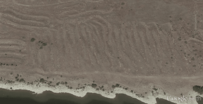


Note to anyone beginning to read this thread: It was determined that the picture shows the remnants of some sort of gold mining operation. The thread then turns a little off track and there is a debate for several pages. Finally we discuss land status and I try to find out who owns this property.
 

Last edited:
Upvote 0
find a huge TIF from Aug 16th 1955 lost a little resolution from the crop & "save for web" to JPG
the construction on the dam started in july 1956 so these piles are much older
not sure if that's a pond in the middle that was filled or what, I would work at the edge of where they left off.
.
View attachment 1301834

Thats a good find! Definitely dredge pilings with fines and nuggets. I would detect it for sure.

If you look at the pic east of that you can see chinaman bar.
 

I did some more research today. I found a record for the MTP that shows all the land status changes and so forth. It agrees with the patent I found from the GLO that the entire NE 1/4 of section 8 homesteaded in 1909. It also shows another patent in the same section, part of which was acquired by the US 41 years later, but no other records for the part I'm interested in.
Something I noticed that was confusing me is that the SE&SW 1/4s of each 1/4 section are divided into to lots but the NE&NW 1/4 of the quarter section are simply described as NW&NE 1/4 of the ___ 1/4. Why aren't they all lotted out?

I tried to get some help from the county, no luck. I thought the recording office looked like my best bet. Someone told me they just have records, and can't help me with land status, not very helpful. Maybe I will see if the assessor's office can tell me why their records don't match the MTP.
 

Something I noticed that was confusing me is that the SE&SW 1/4s of each 1/4 section are divided into to lots but the NE&NW 1/4 of the quarter section are simply described as NW&NE 1/4 of the ___ 1/4. Why aren't they all lotted out?

In Public Land Survey (PLSS) speak a standard square mile Section is assumed to be split into 16 equal 40 acre quarter quarters. Those equal quarter quarters are called aliquot parts and will be designated by their actual relative location within the quarter quarter grid formed. These are the NENE or SESW marking you see on a map with the full PLSS grid.

Not all Sections are actually a square mile so they can't be divided into 16 equal 40 acre portions (aliquots). The unequal parts left over are described as government Lots - they are NOT aliquots. Only the government Lots are marked out on the Master Title Plat (MTP) - the aliquot quarter quarters are assumed to be equal 40 acre portions (1320 ft X 1320 ft square) and are not depicted on the MTP.

Each Lot will be designated by a number (usually something like L7 or L2) and the actual acreage (usually something like 41.23 or 38.01) will be listed right on the MTP within the tick lines.

I hope that helps. :thumbsup:

Heavy Pans
 

Last edited:
Hello, a quick update: After contacting a few people from the county, all I got was that the parcel I was asking about is owned by the BOR and it is correct becasue it came off some legal record. I found some sales history and saw where it went from private ownership to the BOR however that also came from the assessor's office. I don't know about you but I think I'm going with it's the BOR's right now, not sure if they also go the mineral rights with that and not sure how to find out. No matter though because the part I'm most interested in now is pretty much all within the boundaries of the river. I called the ACOE regulatory office and left a message trying to get an idea of what I can do, several days and no response. I will have to try again. I also tried asking WDFW if they knew about what the policy for the Columbia is, again no response.

More googling turned up a new report giving me some good information I was missing. It said this mine produced some gold and silver in 1939 by dry land dredging. Unfortunately searching dry land dredging only turns up modern methods like vacuuming and dredges that shoot water into your dry hole first.
 

doodlebug:occasion14:....and knew it wasn't blm land...cool you have access within river boundary ...If they get don't get back to you after reaching out? I don't know what you could/should do.
 

I also figured out that the area mined/prospected is way more extensive than I thought. One more large are that was worked in the same method and miles of river with hundreds at least, of test holes on either side of the river.
 

Idk local library. What was your source
 

Could you explain the doodlebug/dragline thing to me? I've been reading and watching videos but I can't get a good idea of how one really works. Do they work at water level like a regular floating dredge so in my case the bar would've had to have flooded up to that height and there could be portions left that the plant couldn't reach?
 

Could you explain the doodlebug/dragline thing to me? I've been reading and watching videos but I can't get a good idea of how one really works. Do they work at water level like a regular floating dredge so in my case the bar would've had to have flooded up to that height and there could be portions left that the plant couldn't reach?

They were mostly made on site for that site...I know it's been a while but ho back towards the beginning of this thread I posted some of the best examples I could find.
Basically a small Mobil wash plant...sometimes floating. Drag line refers to a style of digger that pulled a bucket to the crane and then dumped into the plant or a truck.there were many types of those as well.
 

Top Member Reactions

Users who are viewing this thread

Latest Discussions

Back
Top