Are theses dredge tailings or something?

OwenT

Hero Member
Feb 11, 2015
583
897
Moses Lake WA & Provo UT
Primary Interest:
Prospecting
First thing I thought when I saw this on the Columbia River was dredge tailing, but it's actually more of a snaking pattern than the stacked arcs a dredge would make. This area on the river did produce gold. Untitled.png
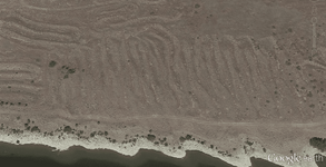


Note to anyone beginning to read this thread: It was determined that the picture shows the remnants of some sort of gold mining operation. The thread then turns a little off track and there is a debate for several pages. Finally we discuss land status and I try to find out who owns this property.
 

Last edited:
Upvote 0
I'm not saying it's wrong....I'm saying everything BUT county says it's wrong....Plat maps don't even show the same subdivisions as the county....
 

I assume that everyone is dizzy and incapable of comprehending facts. The verifiable facts must all be wrong? You all post nothing to verify your claims while ignoring every fact. Is there a name for that?

You are posting a county GIS representation. I can't speak for everyone but that's a bad thing to base your land management research on. I would only rely on a master title plat, not some data a programmer found and pasted into a GIS viewer. If you could show the data was programmed carefully and meticulously from the actual MTP well maybe this would be accurate enough but even then the visual representation could be wrong. I'm not even saying you are wrong but you have to rely on MTP data and I think that's what people are trying to tell you.
 

Sorry but I cant rely on what certain people say due to the fact that they say so much that is verifiably incorrect. Post the data! I wont hold my breath waiting!

I looked it up at MTP. IT shows boundries but not ownership of land. Post something from MTP that shows ownership!

My wager is that no one will post! Any takers?

No I got sheet to do today you look it up:)
 

As usual I get to prove that the same handful of people just post anything that can be verified false.

The pics below show the area. The shaded plots are Federal lands and corresponds with the assessors map.
 

Attachments

  • Screenshot_20160419-151440.png
    Screenshot_20160419-151440.png
    283.9 KB · Views: 88
  • Screenshot_20160419-151512.png
    Screenshot_20160419-151512.png
    145.2 KB · Views: 70
You are posting a county GIS representation. I can't speak for everyone but that's a bad thing to base your land management research on. I would only rely on a master title plat, not some data a programmer found and pasted into a GIS viewer. If you could show the data was programmed carefully and meticulously from the actual MTP well maybe this would be accurate enough but even then the visual representation could be wrong. I'm not even saying you are wrong but you have to rely on MTP data and I think that's what people are trying to tell you.

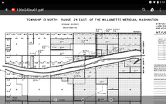
The MTP only shows federal land status. It clearly shows that although Chinaman Bar (Not China Bar downriver) was once public land a patent was granted and it is now private land. Beyond that the MTP does not determine who owns the private land. The tax assessor may have a clue (or not) but the MTP does not show who the private owner is. It only shows the land Owen is studying is not under any federal control or ownership except the reservation to miners, farmers and the federal government to use ditches and canals. You will find that reservation noted on the MTP map as DC and spelled out in the patent documents.

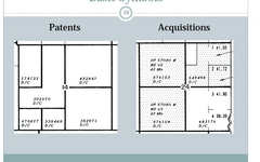
To determine the exact boundaries of the patented land you will need to download the Patent and Patent Survey Plat. The County assessor only tracks tax parcels not land boundaries. That was my point originally in sending Owen to the General Land Office to get the actual location information. The ownership of that land is still to be determined. I'm sure Owen is up to that task and living there he can verify the information he discovers. If not he already stated he will ask more questions here.

Other than the obvious attempts to derail this thread I'm not sure what the drama here is. I do this stuff all day for a living so it doesn't seem difficult to me. To others that are new to land status research it may be more difficult. That's why I offer help if people ask. That's why I create tools to help. The fact that other people have opinions or are confused by the differences in the status of public lands in the west doesn't change the land status.

There are some very basic land status differences between the eastern original colony States, the Northwest Ordinance States and the purchased and conquered public lands western and southern states. I have plans to address those issues in the future but for now please understand those three types of land status are very different. Relying on what you've learned about land ownership in an original colony State like say Pennsylvania doesn't in any way prepare you for understanding land status in the western states. Apples and Oranges.

Perhaps Owen will share what he discovers here. I hope he will but considering the drama created around something as simple as reading a Master Title Plat I wouldn't blame him if he moved on to more productive threads. In the meantime I wish him...

Heavy Pans
 

Last edited:
The MTP only shows federal land status. It clearly shows that although Chinaman Bar (Not China Bar downriver) was once public land it was patented and is now private land. Beyond that the MTP does not determine who owns the private land. The tax assessor may have a clue (or not) but the MTP does not show private ownership. It only shows the land Owen is studying is not under any federal control or ownership except the reservation to miners, farmers and the federal government to use ditches and canals. You will find that reservation noted on the MTP map as DC and spelled out in the patent documents.

To determine the exact boundaries of the patented land you will need to download the Patent and Patent Survey Plat. The County assessor only tracks tax parcels not land boundaries. That was my point originally in sending Owen to the General Land Office to get the actual location information. The ownership of that land is still to be determined. I'm sure Owen is up to that task and living there he can verify the information he discovers. If not he already stated he will ask more questions here.

Other than the obvious attempts to derail this thread I'm not sure what the drama here is. I do this stuff all day for a living so it doesn't seem difficult to me. To others that are new to land status research it may be more difficult. That's why I offer help if people ask. The fact that other people have opinions or are confused by the differences in the status of public lands in the west doesn't change the land status.

There are some very basic land status differences between the eastern original colony States, the Northwest Ordinance States and the purchased and conquered public lands western and southern states. I have plans to address those issues in the future but for now please understand those three types of land status are very different. Relying on what you've learned about land ownership in an original colony State like say Pennsylvania doesn't in any way prepare you for understanding land status in the western states. Apples and Oranges.

Perhaps Owen will share what he discovers here. I hope he will but considering the drama created around something as simple as reading a Master Title Plat I wouldn't blame him if he moved on to more productive threads. In the meantime I wish him...

Heavy Pans

China Bar mine is 142 miles away (upriver) from priest rapids dam.

Chinaman bar was once private land and is now BLM land. I already posted that verified info. Actually that land went from public to BOR to BLM.
http://grantwa.taxsifter.com/Assessor.aspx?keyId=1593154&parcelNumber=150760000&typeID=1

http://www.treasurenet.com/forums/newreply.php?do=newreply&p=4948000
 

Last edited:
Wow.. that escalated quickly. And to think I wasn't even involved in the thread...imagine that. But the common denominator to all threads that get deleted sure was...

I'm SURE you know who who you are..
 

Yes they get deleted and locked when I prove that I am correct and the same handful push the report button and complain to the moderators.
 

Thank you Clay...damn fine explanation; understandable even to those of
us that don't do much of that type of research. The info and data you
provide is invaluable...
respect-062.gif~original


As for the drama, watch the clip below up to the 1:37 mark. If folks understand,
then this kind of thing will stop, and we'll all get a much more harmonious outcome
for our time spent in the forum.


Last edited:
I assume that everyone is dizzy and incapable of comprehending facts. The verifiable facts must all be wrong? You all post nothing to verify your claims while ignoring every fact. Is there a name for that?


I assume your trying to get a timeout, if not STOP insulting members here...

Yes they get deleted and locked when I prove that I am correct and the same handful push the report button and complain to the moderators.

Posts get reported and deleted or threads locked when rules are violated, it has nothing to do with who is right or wrong.....


Again STOP INSULTING MEMBERS! It is not open for debate, no reply necessary....
 

find a huge TIF from Aug 16th 1955 lost a little resolution from the crop & "save for web" to JPG
the construction on the dam started in july 1956 so these piles are much older
not sure if that's a pond in the middle that was filled or what, I would work at the edge of where they left off.
.
old_1955_CIH_3P_126.jpg
 

The MTP only shows federal land status. It clearly shows that although Chinaman Bar (Not China Bar downriver) was once public land a patent was granted and it is now private land. Beyond that the MTP does not determine who owns the private land. The tax assessor may have a clue (or not) but the MTP does not show who the private owner is. It only shows the land Owen is studying is not under any federal control or ownership except the reservation to miners, farmers and the federal government to use ditches and canals. You will find that reservation noted on the MTP map as DC and spelled out in the patent documents.

To determine the exact boundaries of the patented land you will need to download the Patent and Patent Survey Plat. The County assessor only tracks tax parcels not land boundaries. That was my point originally in sending Owen to the General Land Office to get the actual location information. The ownership of that land is still to be determined. I'm sure Owen is up to that task and living there he can verify the information he discovers. If not he already stated he will ask more questions here.

Other than the obvious attempts to derail this thread I'm not sure what the drama here is. I do this stuff all day for a living so it doesn't seem difficult to me. To others that are new to land status research it may be more difficult. That's why I offer help if people ask. That's why I create tools to help. The fact that other people have opinions or are confused by the differences in the status of public lands in the west doesn't change the land status.

There are some very basic land status differences between the eastern original colony States, the Northwest Ordinance States and the purchased and conquered public lands western and southern states. I have plans to address those issues in the future but for now please understand those three types of land status are very different. Relying on what you've learned about land ownership in an original colony State like say Pennsylvania doesn't in any way prepare you for understanding land status in the western states. Apples and Oranges.

Perhaps Owen will share what he discovers here. I hope he will but considering the drama created around something as simple as reading a Master Title Plat I wouldn't blame him if he moved on to more productive threads. In the meantime I wish him...

Heavy Pans

I sure will share whatever I find out, whether it be here or another thread which may be useful to others so they need not have to sift through to find something relevant.
 

find a huge TIF from Aug 16th 1955 lost a little resolution from the crop & "save for web" to JPG
the construction on the dam started in july 1956 so these piles are much older
not sure if that's a pond in the middle that was filled or what, I would work at the edge of where they left off.
.
View attachment 1301834
Cool I couldn't find anything earlier than '64. Even there they look 20 years old. That sharkfin pattern could be influenced by the tailings fom the op being discharged at the shore. VVould be nice to have an Idea of the plant they used.
 

Hey Owen, You know how and where to go do your research for yourself. A lot of people here DO know what they're talking about some not so much. Good luck on your adventure. Keep us posted go get the gold!
 

The MTP only shows federal land status. It clearly shows that although Chinaman Bar (Not China Bar downriver) was once public land a patent was granted and it is now private land. Beyond that the MTP does not determine who owns the private land. The tax assessor may have a clue (or not) but the MTP does not show who the private owner is. It only shows the land Owen is studying is not under any federal control or ownership except the reservation to miners, farmers and the federal government to use ditches and canals. You will find that reservation noted on the MTP map as DC and spelled out in the patent documents.

To determine the exact boundaries of the patented land you will need to download the Patent and Patent Survey Plat. The County assessor only tracks tax parcels not land boundaries. That was my point originally in sending Owen to the General Land Office to get the actual location information. The ownership of that land is still to be determined. I'm sure Owen is up to that task and living there he can verify the information he discovers. If not he already stated he will ask more questions here.

Other than the obvious attempts to derail this thread I'm not sure what the drama here is. I do this stuff all day for a living so it doesn't seem difficult to me. To others that are new to land status research it may be more difficult. That's why I offer help if people ask. That's why I create tools to help. The fact that other people have opinions or are confused by the differences in the status of public lands in the west doesn't change the land status.

There are some very basic land status differences between the eastern original colony States, the Northwest Ordinance States and the purchased and conquered public lands western and southern states. I have plans to address those issues in the future but for now please understand those three types of land status are very different. Relying on what you've learned about land ownership in an original colony State like say Pennsylvania doesn't in any way prepare you for understanding land status in the western states. Apples and Oranges.

Perhaps Owen will share what he discovers here. I hope he will but considering the drama created around something as simple as reading a Master Title Plat I wouldn't blame him if he moved on to more productive threads. In the meantime I wish him...

Heavy Pans

Sorry you are right I meant the patent plat you referred to and ruined the whole point I was trying to make haha.
 

winner, that's a great picture, thanks. I'm amazed that that orchard in the lower left is there but there's not even a trace of the highway that runs right by the river today.

Goldwasher, I was wondering about that pattern myself.
 

Might get better resolution if you download the TIF's
Central Washington Historical Aerial Photography Project

looked at the next photo south on the grid it clearly shows a sand spit, that area had to be filled, a flood would have washed the tailing piles also
I've seen navigation dredges on the coast dredge the channel then unload to land, but I don't know, another mystery!
 

Last edited:

Top Member Reactions

Users who are viewing this thread

Back
Top