Are theses dredge tailings or something?

OwenT

Hero Member
Feb 11, 2015
583
897
Moses Lake WA & Provo UT
Primary Interest:
Prospecting
First thing I thought when I saw this on the Columbia River was dredge tailing, but it's actually more of a snaking pattern than the stacked arcs a dredge would make. This area on the river did produce gold. Untitled.png
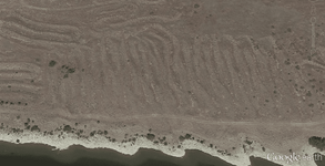


Note to anyone beginning to read this thread: It was determined that the picture shows the remnants of some sort of gold mining operation. The thread then turns a little off track and there is a debate for several pages. Finally we discuss land status and I try to find out who owns this property.
 

Last edited:
Upvote 0
Sorry but I looked at historic aerials first. Their earliest aerial was taken after the dam was built so their image can not possibly predate the dam
 

Ok you keep believing that while you have no other feasible explanation.
Neither do you and your theory has been soundly disproved. I believe they are from a placer operation. I could be incorrect. Your pictures are of a different area and not taken at or near the piles that are by Chinamens Bar.
 

Chinaman bar is two miles farther from the dam than the piles. There are no piles at chinamans bar.

Chinaman Bar Placer
 

Sorry but I looked at historic aerials first. Their earliest aerial was taken after the dam was built so their image can not possibly predate the dam
therefore your assumtion may be incorrect...the aerial pictures you couldn't share couldn't have proved your point thanks for clarifying:thumbsup: so the assumption that they hauled dirt three miles to just dump it is based on?
 

Chinaman bar is two miles farther from the dam than the piles. There are no piles at chinamans bar.

Chinaman Bar Placer
the accuracy of the location of chinamens bar is up in the air that as already discussed. Im referring to the area as that since it is the closest knon placer area.
 

interesting that the only describable "bar" in the river for miles is actually adjacent to the piles. There is a VERY strong chance that the location as marked is off by several miles.
 

If you read about chinaman bar you will see it was an insignificant deposit. But hay what does the USGS know?
 

There info is not as dependable as yours? Please do post something showing that the location is disputed or unknown. Make sure that you have the correct chinaman bar. There are three of them! Two are on the other side of the river.
 

Time for sleep! I have to go to the range tomorrow to make sure my gun is sighted in. Going on a feral hog hunt!
 

Well thanks to both of you for doing all this free research for me :laughing7:. I thank you chlsbrns for the input especially the history links, but I'm going to have to go with Goldwasher on this one. Like I said before I don't have much faith in the accuracy of the location descriptions, not that it even changes the fact that there's gold where I found it. Just looking at this logically, where there's gold in the dirt and it seems like there's been mining activity, I'm saying this was a mine. One thing I thought about today was I don't believe this was probably a floating operation as the piles are at least 10' maybe closer to 20' above the present water line which should be about the same as it was back in the day. So here's some pictures I took. DSC02285.JPGDSC02283.JPG
 

Owen, I'm wondering if both Chls and GW are right.

There could have been a time, perhaps during the dam construction,
that they felt it necessary to dredge the bottom in that area in order
to make it deep enough for a larger boat/ship to dock there or pass
through there. It may even have been looked at as the possible dam
site, but they chose the upriver location instead.

It's most definitely river rock, but then I believe that entire canyon
was the riverbed at one time.

Gotta love a good mystery...
spider-0173.gif~original


You say you did get some gold out the samples you took?

Is it dry enough (yet) for a drywasher? If so, might be a great spot
to work for awhile!
 

You're right, everything down there is river gravels, but really the entire Columbia Basin is river gravels, either from the Columbia proper or from one of the Missoula Floods. I think a lot Grant Co has been underwater at some point or another. We dry classified a bucket of dirt and panned it at the river. One real flake and a few colors in one pan. At least 10 specs per pan and maybe close to 30 in one. Drywashing could be a possibility but I would have to go back and get some better tests, I didn't really find enough while we were there to get real excited.
 

You guys are funny! I don't see how a mine location covering such a vast area could not be recorded in mining records. Unless of course they didn't care if others claimed it and took it away from them.

What I do know is that it in not chinaman bar placer.

Is the ground claimed? Claimable? Private property? Who owns the mineral rights?
 

Last edited:
Owen, I'm wondering if both Chls and GW are right.

There could have been a time, perhaps during the dam construction,
that they felt it necessary to dredge the bottom in that area in order
to make it deep enough for a larger boat/ship to dock there or pass
through there. It may even have been looked at as the possible dam
site, but they chose the upriver location instead.

It's most definitely river rock, but then I believe that entire canyon
was the riverbed at one time.

Gotta love a good mystery...
spider-0173.gif~original


You say you did get some gold out the samples you took?

Is it dry enough (yet) for a drywasher? If so, might be a great spot
to work for awhile!
I said it could have been plausable. The pictures tell a different story. The piles being dumped in the pics. and the gravel plant are both farther up river than the piles near Chinamens placer area.

There are hundreds of medium to large mining ops that never got recorded and if you see the same name in an area several times it usually means that there as one location and several people put it on paper and then into the later record incorrectly because the sites are gone and hard to find once in the field. The links that get shared verify that constantl;y...most google earth layers do it consistantly antone ho uses mindat and usgs sources sees it a lot. Minecache is terrible about it.

If you compare the more recent field surveys performed by USGS to help close and make safe abandoned mines ith historical record the ne USGS surveys are missing more than fifty percent of the originally named mines. There are three hundred knon mines listed in the three mile radius around my house. locating fifty of them is very difficult for those three hundred knon there are probably double that in prospects and surface digs that never had a name.

In a river basin full of gravel and open space the engineers definetely didn't have to source gravel or fill and they didn't have to travel far to get dredged material out of the area. In the construction photos of the dam site (The pic is labled Priest Rapids keep that in mind a rapid doesnt keep its name three miles distant) you can see them lining the piles in straight lines..it is eather for a temporary earth coffer dam or part of the dam on the northern shore. looks like the area that has modular homes presently is close to those piles in the pic.

That is a placered area. There seems to be some impliment in the google earth image close to the orchard that is there...any idea hat that is? You can also see that some of the piles have been semi leveled closer to the farming area.

A historic photo predating the dam could help a lot. In the 1964 image those piles had been there for years predating the dam. The date O.t. gave as 30's-40's I suspect it as called Chinamens Bar long before the 30's and 40's

I kno Chrls thinks im just arguing none of my logical points and picture angles have been soundly disproved because they cant be. Boots on the ground should clear it up even more my points are pretty logical I hope they help.

P.s. My double u key is broke lol....and cue...its amazingly difficult to put all letters in to groups and not have those 2 letters if you could imagine:BangHead:
 

its private land there is DOD past the area . Some state and blm nearby but, not close really. Make sure you get permission...... O IN T
 

There is Fish and game land touching the river adjacent to the DOD land same side of river as the piles could be a good spot to sample.
 

looks like the DOD is the major landholder in the area some of it had historical claims...are you guys alloed to poke around on DOD land? Fish and game land for miles over river actually also.
 

Top Member Reactions

Users who are viewing this thread

Latest Discussions

Back
Top