Anatomy of a treasure legend

Crow, I did want to thank you for the link to the county maps. They look like a good research tool that can be used in other research.

I have a flaw in not knowing when to quit. I'm reminded of the old adage; "We learn more and more about less and less until we know everything about nothing."

Two more articles that kind wrap up Ko Ko's involvement in the 1915 story. Since it appears she didn't speak much English, if any at all, we have to ask to whom she is telling this treasure story? Her son John seems like the source for the story being told to the American white searchers. It makes us wonder if he just learned of the story when she reached death's door.

La Grande Observer (La Grande, Oregon), March 18, 1915, Page 5

attachment.php


East Oregonian (Pendleton, Oregon), March 15, 1915, Page 8

attachment.php


I'm using the Pendelton article to determine her death date, March 14, 1915. [died yesterday and the article is March 15]

From these accounts, it sounds like the 1895 gold was buried near her tepee in a location other than the tepee in which she died?

Garry
 

Attachments

  • Death of Ko-Ko-ye-a- lash.JPG
    Death of Ko-Ko-ye-a- lash.JPG
    77.5 KB · Views: 84
  • Death of Ko-Ko-ye-a- lash (Pendelton).JPG
    Death of Ko-Ko-ye-a- lash (Pendelton).JPG
    28 KB · Views: 92
Last edited:
Crow, I did want to thank you for the link to the county maps. They look like a good research tool that can be used in other research.

I have a flaw in not knowing when to quit. I'm reminded of the old adage; "We learn more and more about less and less until we know everything about nothing."

Two more articles that kind wrap up Ko Ko's involvement in the 1914 story. Since it appears she didn't speak much English, if any at all, we have to ask to whom she is telling this treasure story? Her son John seems like the source for the story being told to the American white searchers. It makes us wonder if he just learned of the story when she reached death's door.

La Grande Observer (La Grande, Oregon), March 18, 1915, Page 5

attachment.php


East Oregonian (Pendleton, Oregon), March 15, 1915, Page 8

attachment.php


I'm using the Pendelton article to determine her death date, March 14, 1915. [died yesterday and the article is March 15]

From these accounts, it sounds like the 1895 gold was buried near her tepee in a location other than the tepee in which she died?

Garry

I agree. A former /different teepee location than her current lodge at the time of death.
Or more specifically , a former location of a teepee she had occupied 19 years prior.

There are ifs of speculation. (Yes , danger warning... Don't speculate.) Of IF other lodges were on the same site, (Did she own the land then? Or was it a general , open to any reservation member availability of site then?) Layouts had a logic to a camps set up. Not our logic. But to it's users. Status , rank, ect. could apply.
So too though would an individual's lodge location have a logic to the user. Even if it was the only one on a site.
Our lady's not pinpointing the "X" could have been due to illness /mental condition , or from trying to see the site from nearly two decades ago.
A single lodge? Or multiple? More than a lodge could apply for a single dwellings structures too.
And did she at times back years ago , move /relocate her lodge multiple times?

I have to bring up the gold. Did she have all of it already saved 20 years prior?
Maybe she made annual deposits to the burried container?

Maybe maybe :)
 

Edit ,for attempted clarity.
In reference to the 19 year old/former teepee site.
Yes , she owned land she leased out.
But was the 19 year old site communal?
 

Edit ,for attempted clarity.
In reference to the 19 year old/former teepee site.
Yes , she owned land she leased out.
But was the 19 year old site communal?

I suspect that it was communal.
That was their culture, to be in a group. Working together.
Hard to do if everybody is all spread out on their various allotments of land.
And yes, 19 years, not 20. :)
 

I was never sure how Robert Kirkpatrick could claim anything he and his boys would find. He must have believed he had some kind claim because they were the ones doing the digging and footing the expense.

I ASSUMED he was searching on Ko Ko's 80 acres of leased land and maybe had some claim due to that fact. I certainly wouldn't have believed tha
t he searching on communal tribal land. :icon_scratch:

The other possibility was that Ko Ko's tepee once was located of the 60 acres Edward Kirkpatrick owned and where it appears he had a residence. It was directly west of Ko Kos allotment and contained the Kirkpatrick house Ko Ko was trying to reach after her son's assault. We don't know how he obtained title to that portion, but it was at one time Indian land. In 1895 it was almost surely Indian land. The Kirkpatrick's didn't even arrive until about 1900.


Garry
 

Last edited:
I was never sure how Robert Kirkpatrick could claim anything he and his boys would find. He must have believed he had some kind claim because they were the ones doing the digging and footing the expense.

I ASSUMED he was searching on Ko Ko's 80 acres of leased land and maybe had some claim due to that fact. I certainly wouldn't have believed tha
t he searching on communal tribal land. :icon_scratch:

The other possibility was that Ko Ko's tepee once was located of the 60 acres Edward Kirkpatrick owned and where it appears he had a residence. It was directly west of Ko Kos allotment and contained the Kirkpatrick house Ko Ko was trying to reach after her son's assault. We don't know how he obtained title to that portion, but it was at one time Indian land. In 1895 it was almost surely Indian land. The Kirkpatrick's didn't even arrive until about 1900.


Garry

Land was fragmented.
"Poker Jim "put it well back in 1920 as far as Indians being allowed to sell...

[Poker Jim’s statement appealed to Sells to help educate young men who, as soon as they got their allotment, would “sell their land and then they do not have any land and do not have any money because the money is soon spent and drawn, and the Indians are left without any home or any land to live on. Pretty soon, if you let them go on this way, the old Indians will be dead, and the young Indians will be beggars, because they will waste their land and money if they get patents.”

https://www.eastoregonian.com/news/...cle_2613b7d4-bfd8-11eb-b321-b3d00dd67255.html

Despite Poker Jim’s request, non-Indians were allowed to purchase lands across the reservation.]
 

Gidday Amigos

Maybe John Mitchell was given 40 acres as child? Another factor worth investigation for clarification was John Mitchell was some times recorded on Indian roles with his mum Ko Ko ya a las . But his name was John Wilson?

Here is some interesting. in 1894 on the Indian roles 1885 to 1940 Umatilla Oregon shows John M Wilson and his mother Ko Ko a ye las.

attachment.php


in 1895 on the Indian roles 1885 to 1940 Umatilla Oregon shows John M Wilson and his mother Ko Ko a ye las.

attachment.php


In 1910 on the Indian roles 1885 to 1940 Umatilla Oregon shows John M Wilson and his mother Ko Ko a ye las.

attachment.php


So we could conclude the Letter M was for Mitchell? Johns Full name was John Mitchell Wilson?

This is interesting as on the 1914 property map. you can see a John Wilson had 30 acres near his mothers property?

attachment.php


interesting a John M Wilson a 1889 land patient. He seems to obtained more than one?

Name:John M Wilson
Issue Date:9 Jul 1889
Place:Umatilla, Oregon, USA
Township:002s
Range:030E
Aliquots:W?SE?
Section:22 160 acres
Accession Number:ORLGAA 081569
Document Number:1789


In 1908 he gained another grant.

attachment.php


Why is his property on the 1914 map showing only 30 acres did he sell some of his land off the Kirkpatrick brothers?

Crow
 

Attachments

  • KO KO A YE LAS JOHN M  WILSON 1894 ROLL IN 1885 -1940 INDIAN CENSUS ROLES..JPG
    KO KO A YE LAS JOHN M WILSON 1894 ROLL IN 1885 -1940 INDIAN CENSUS ROLES..JPG
    38.4 KB · Views: 153
  • KO KO A YE LAS JOHN WILSON 1895 ROLL IN 1885 -1940 INDIAN CENSUS ROLES..JPG
    KO KO A YE LAS JOHN WILSON 1895 ROLL IN 1885 -1940 INDIAN CENSUS ROLES..JPG
    46.7 KB · Views: 153
  • KO KO A YE LAS JOHN WILSON 1910 ROOLL IN 1885 -1940 INDIAN CENSUS ROLES..JPG
    KO KO A YE LAS JOHN WILSON 1910 ROOLL IN 1885 -1940 INDIAN CENSUS ROLES..JPG
    53.4 KB · Views: 156
  • JOHN M MITCHEL 1914 LAND MAP 30 ACRES KO KO AYE LAS 80 ACRES.JPG
    JOHN M MITCHEL 1914 LAND MAP 30 ACRES KO KO AYE LAS 80 ACRES.JPG
    124.1 KB · Views: 158
  • john wilson 160 acres given to him in 1908.JPG
    john wilson 160 acres given to him in 1908.JPG
    77.2 KB · Views: 165
Section 17 in the second article is the location of a grant for 160 acres.
The earlier document is a Patent for 160 acres in section 22.

Perhaps a grant is a distribution of land. Seems at no cost from dim recollection. (The courser land near me was post Civil war grants to encourage settlement.)
Terms likely varied , but homesteading/occupying it for a specified minimum of time, and maybe working it could be requirements.

A patent may have made selling the land possible.

Grant vs. Patent?
 

Wow...great thread...only one question ?..... who gets to dig when you guys put an X on those maps !!:laughing7::laughing7::headbang:
 

Wow...great thread...only one question ?..... who gets to dig when you guys put an X on those maps !!:laughing7::laughing7::headbang:

Gidday El Barto

Perhaps its already long gone?

attachment.php


But nah! The threads intentions was show how much a treasure yarn can be dissected more than an actual treasure recovery. But who knows amigo!

Crow
 

Attachments

  • 1200x0.jpg
    1200x0.jpg
    214.4 KB · Views: 164
Last edited:
Touching again on the question of Ko Ko ye a lash being able to accumulate a cache, I want to add a few things.
The map below is an expanded version of the one Crow shared. We see that Ko Ko ye a lash's Allotment includes an additional 80 acres in addition to the original 80 acres. This would probably double her revenue from the leases she leased to Edward Kirkpatrick, now 160 acres. Map is from 1914.


attachment.php


There were three patents issued to John Mitchell, Ko Ko ye a lash's son, beginning in 1912. I want to make sure everything is readable (Not blurred) so I have not scanned the records in their entirety. For anyone wishing to view the complete record, visit the BLM Site https://glorecords.blm.gov/ and select Patents and follow the menu and you will be able to see the patent image.

Patent No. 243226 issued January 18, 1912 to John Wilson alias John Mitchell for 32 acres
attachment.php


Patent No. 516223 issued February 29, 1916 (leap year) John Mitchell or John Thomas for 80 acres inherited from his mother.

attachment.php


Patent No. 703472 issued Aug 25, 1919 to John Mitchell or John Thomas for 80 acres inherited from his mother.

attachment.php


I believe Ko Ko gained one of the 80 acre tracts thru inheritance. More on that later.

The 80 acre tract descriptions, don't indicate which was inherited and which was Ko Ko's allotment. This possibly impacts the 1895 alleged treasure burial site. I believe Ko Ko's tepee location in 1895 was different than the location her tepee occupied in the 1909 assault incident. I believe her tepee in 1909 was on the northern 80 acres near where Edward Kirkpatrick was living, but the 1895 treasure could have been on either allotment.

Note: We see Ko Ko identified on one patent as "Crow". Crow appears on a few of the early the Indian Rolls as her English Name.

Another item, worth pointing out, are the numbers in the upper left hand corner. On John?s 32 acres we see 223 and on Ko Ko's 80 acre plots we. see 221. These numbers were assigned, to those having an allotment, for tracking purposes by the government and were in use beginning about 1910. The actual number also denoted the tribe which, in John and Ko Ko's case, was the Cayuse Tribe. Hence Ko Ko was C-221 and John was C-223. These proved invaluable tracking John with the frequent name changes.

Garry
 

Attachments

  • Ko Ko & John Mitchel's Allotment (1914) -1.jpg
    Ko Ko & John Mitchel's Allotment (1914) -1.jpg
    641.1 KB · Views: 136
  • Excerpt John's 32 Acre Allotment.JPG
    Excerpt John's 32 Acre Allotment.JPG
    74.9 KB · Views: 125
  • Excerpt Ko Ko's 80 Acre Allotment Inherited by John -1.JPG
    Excerpt Ko Ko's 80 Acre Allotment Inherited by John -1.JPG
    60.1 KB · Views: 131
  • Excerpt Ko Ko's 80 Acre Allotment Inherited by John.JPG
    Excerpt Ko Ko's 80 Acre Allotment Inherited by John.JPG
    73.4 KB · Views: 131
Last edited:
Gidday Garry

Some excellent points.

The claim of land in question in regards to where this teepee was in 1895 was 1.5 miles from the Indian Agency. The second southern 80 acre property is pretty spot on being 1.5 miles from the agency. As you can see below.

attachment.php


Kp Ko a ye las Having at least two 80 acre properties owned by her and it appears her son John M Wilson was given some acres on 9 Jul 1889 section 22 160 acres. She was getting rent no only from her two properties of 80 acres she was most likely reviving rent for a further 160 acres that was granted to her son when he was born until he came of age? Thus she was earning in rent perhaps 4 times our earlier estimate on what she was earning on 80 acres?

Crow
 

Attachments

  • kokoa dlash properties.JPG
    kokoa dlash properties.JPG
    89.3 KB · Views: 119
Crow, Interesting post on the 1 1/2 mile distance. I have not looked at the 160 acres you have identified.

Allotment Background: [Latter Day Saints, familysearch web site]

The General Allotment Act was passed by the U.S. Congress in 1887, marking the establishment of the allotment of land to individuals as the official and widespread policy of the federal government toward the Native Americans. Under this policy, land (formerly land held by the tribe or tribal land) was allotted to individuals to be held in trust until they had shown competency to handle their own affairs.

Individual American Indians were given a prescribed amount of land on a reservation based upon what land was available and the number of tribal members living on that reservation. Generally, the amount of land allotted was 160 Acres for each head of family, 80 Acres for each single person over eighteen years of age, 80 Acres for each orphan child under eighteen years of age, and 40 Acres for each single person under eighteen years of age.

I'm confused about the orphan child reference. I would have thought that any child in the family under 18 would have been eligible for an allotment?

Indian Rolls Background: [ancestry.com]

The government started conducting an enumeration in 1886 up until 1937 of the Indians on the reservations.

From the 1900 U.S. census, it appears the allotments were assigned in 1891 to all of those eligible. We also see that Ko Ko had 7 children and only one was still living in 1900.

I was unable to locate Ko Ko in the 1886 Indian Rolls and we first pick her up first in the 1887 rolls.


attachment.php


Her husband is Michael 35 yrs old, wife Ko Ko (English Name Crow) 40 yrs old, son Alexander Wilson 19 yrs old and daughter Ko pe el 3 years old. They continue to appear every year until 1891. There is a John Mitchell 1/2 yr old in 1891 but he is listed alone with the Umatilla tribe.:icon_scratch:

Michael and Ko pe el are missing in 1892 when only widow Ko Ko, son Alexander Wilson and son John Mitchel appear. Michael and Ko pe el have died.

1892 Indian Rolls

attachment.php


Something seems amiss with John. Thomas M Wilson is surely our John as he was born in about 1888 or 1889 and this is the first time he shows up in the rolls with Ko Ko? Where was he in the earlier Rolls?

1893 Indian Rolls

attachment.php


Alexander Wilson is missing and he has apparently died. Since he was alive in the 1892 rolls, 24 years old, he would have been eligible for an allotment of 80 acres. [80 Acres for each single person over eighteen years of age], apparently Ko Ko (widow) would have been eligible under this provision.

John would fall under the provision [40 Acres for each single person under eighteen years of age].

At this time, I believe the three land patents, earlier referenced, issued by the government, were originally assigned to Alexander (80 acres), Ko Ko (80 acres) and John (40 acres). Ko Ko was Alexander?s only heir and that is how she came to have the rights to the additional 80 acres.

We don't know which 80 acres was Ko Ko?s allotment or which one was Alexander's but whichever the case the family could have been living on the southern allotment in Section 23 in 1895.

BTW John shows up in the Indian Rolls until the last one in 1937. The reason we didn't find him there earlier was because he was listed as John Thomas. We know this is the correct John because his assigned Indian Number, C-223, was always included in the rolls.

That's my story and I'm sticken to it
. :D

Garry
 

Attachments

  • Ko Ko's Family in 1887 Indian Rolls.JPG
    Ko Ko's Family in 1887 Indian Rolls.JPG
    51.2 KB · Views: 104
  • Ko Ko's Family in 1892 Indian Rolls.JPG
    Ko Ko's Family in 1892 Indian Rolls.JPG
    39.7 KB · Views: 100
  • Ko Ko's Family in 1893 Indian Rolls.JPG
    Ko Ko's Family in 1893 Indian Rolls.JPG
    21.2 KB · Views: 102
Last edited:
Gidday Garry

Some excellent points.

The claim of land in question in regards to where this teepee was in 1895 was 1.5 miles from the Indian Agency. The second southern 80 acre property is pretty spot on being 1.5 miles from the agency. As you can see below.

attachment.php


Kp Ko a ye las Having at least two 80 acre properties owned by her and it appears her son John M Wilson was given some acres on 9 Jul 1889 section 22 160 acres. She was getting rent no only from her two properties of 80 acres she was most likely reviving rent for a further 160 acres that was granted to her son when he was born until he came of age? Thus she was earning in rent perhaps 4 times our earlier estimate on what she was earning on 80 acres?

Crow

Hola Crow

The yellow block should be the block next door west of southern highlighted block.You really need to get new glasses amigo.:tongue3:

My guess is your experiencing what we have experienced in one time or another distraction. Your wife and your 1 month old baby daughter, hyper active 5 year old son and elderly 90 year old parent with dementia going through a second childhood is keeping your hands full?


Kanacki
 

Last edited:
Aw Kanacki ya onto me!

It a mad house at present. Being a late in life of experiencing parenthood I thought it was piece of cake?

Ah I bet there is few reading that are laughing....:laughing7: When I first took my son to school all the parents there was in their 20's and 30's all at a age I could of been their dad.

And I am retired with money coming in everyday without having to get out bed. Yet here I am with not enough hours in a day with constant distractions and interruptions. A wife keeping me on the straight and narrow, a hyper active son son, a month old baby girl who likes snoozing on my belly, Couple that with caring for my mum going through a second childhood at the same time. Enough for old Crow to pull his feathers out.:laughing7:

Then add a Covid lock down......

attachment.php


So yeah amigos Some times I muddle things.....

So apologies in advance.

Crow
 

Attachments

  • tenor.gif
    tenor.gif
    314.4 KB · Views: 97
Last edited:
Gidday Amigos

Corrected image of Ko Ko a ye las second 80 acre southern property. 1.5 miles from Indian Agency as per newspaper story.

attachment.php


Here is John Mitchell John M Wilson 1/18/1912. John M Wilson 7/09/1899. John M Wilson 5/3/ 1904

attachment.php

Here is John Mitchell John M Wilson 1/18/1912 John Mitchell Thomas kokoyealash 8/25/1919.John Mitchell Thomas kokoyealash. 02/291916.

attachment.php

So it appears correct John kokoyealash had two 80 acre properties. While her son in various name versions had 3 properties 1912, 1916 and 1919, the last 2 was his mothers property he inherited.

1899, 1904, John M Wilson was 1899 and 1904 who sold 160 acres in 1908 was different person. They was a homestead patient or grant.

Crow
 

Attachments

  • corrected ko ko a ye las southern property.JPG
    corrected ko ko a ye las southern property.JPG
    96.6 KB · Views: 86
  • john wilson bld.JPG
    john wilson bld.JPG
    90.3 KB · Views: 91
  • john mitchell.JPG
    john mitchell.JPG
    85.1 KB · Views: 89
Last edited:
Just summing up with some of the excellent work Gary and others contributed. Well done!:thumbsup:


We have established that all the key players in the story is real. The fact that Ko ko a ye las ( various spellings variations etc ) had rent from at least two properties. One as Garry rightly pointed inherited from her other son that died. While it does no show that she buried any money? It does she had some economic capacity to do so?

Crow
 

Last edited:
Gidday Amigos

Ko ko a ye las property below from above notice the small gully running from northwest to south east through the property? This is the southern property 1.5 km from the Indian Agency as per newspaper story.

attachment.php


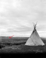
Now you can see below a picture of a lone teepee on a property. This photograph from a collection of Photographs taken of Cayuse Indians at Umatilla Indian reservation between 1888 and 1916 by Major Moorhouse

attachment.php


The following hypothesis You can see the view looking to the southeast towards the mountains the teepee is north of the gully which is going from northwest to south east. But most of all you can see a fence line dividing patented properties. I pose the question is this lone teepee, actually the teepee of Ko ko a ye las? If so the position of the little gully and fence line with the teepee might help us find the exact position the teepee was on Ko Ko a ye las property? The red x on the top view could be the site of where the teepee was on the property?

At this angle ko ko a ye las property that was only one having a fence and gull in the right position and the hills match in the background. Following picture below on the south east one 80 acre property across with the same view of the hills in the south East. ko ko a ye las property is just out of the picture red arrow. You will see the hill line very similar

attachment.php


Was this the location of Ko ko a ye las teepee in 1895?

We do not know for sure it is just one hypothesis.

Crow
 

Attachments

  • ko ko southern property blown up from above.JPG
    ko ko southern property blown up from above.JPG
    53.4 KB · Views: 69
  • lone teepee.png
    lone teepee.png
    109.7 KB · Views: 76
  • looking south east.JPG
    looking south east.JPG
    43.7 KB · Views: 69
Gidday Amigos

Ko ko a ye las property below from above notice the small gully running from northwest to south east through the property? This is the southern property 1.5 km from the Indian Agency as per newspaper story.

attachment.php


Now you can see below a picture of a lone teepee on a property. This photograph from a collection of Photographs taken of Cayuse Indians at Umatilla Indian reservation between 1888 and 1916 by Major Moorhouse

attachment.php


The following hypothesis You can see the view looking to the southeast towards the mountains the teepee is north of the gully which is going from northwest to south east. But most of all you can see a fence line dividing patented properties. I pose the question is this lone teepee, actually the teepee of Ko ko a ye las? If so the position of the little gully and fence line with the teepee might help us find the exact position the teepee was on Ko Ko a ye las property? The red x on the top view could be the site of where the teepee was on the property?

At this angle ko ko a ye las property that was only one having a fence and gull in the right position and the hills match in the background. Following picture below on the south east one 80 acre property across with the same view of the hills in the south East. ko ko a ye las property is just out of the picture red arrow. You will see the hill line very similar

attachment.php


Was this the location of Ko ko a ye las teepee in 1895?

We do not know for sure it is just one hypothesis.

Crow

Hola raggedy old Crow

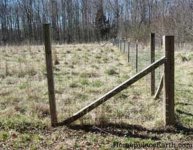
If you look at the picture you posted of the Teepee you can see the corner post of a one time wire fence. That corner post has a sloping brace.... just like the corner post below as an example.

fence-corner.jpg

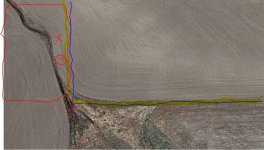
Even to day the boundaries can still be seen and strange enough as this little gully runs into the corner of 2 adjoining properties east of Ko Ko a ye las southern 80 acre allotment. It does seem to match although no fences are there today the property line are still there to see from above. The map below showing ko ko a ye las property of the left and two adjoining properties on the right and approximate positions of the small gully fence line and corner post

search area 3.JPG

So in effect if this picture of the teepee is of ko ko a ye las on her property in which it was claimed in the 1915 newspaper story that she had a teepee on her property in 1895. That the gully matches the intersecting of 3 other properties like the two lots next door to ko ko a ye las lot.?

hgghg corner post.jpg

Then we could have a more realistic search area around the proximity of where the teepee was on ko ko a ye las property.

That is just one hypothesis of course.

Kanacki
 

Last edited:

Top Member Reactions

Users who are viewing this thread

Latest Discussions

Back
Top