A GUIDE TO VAULT TREASURE HUNTING (Condensed)

Entirely possible that the ones I have were hit by lightning since they are older, larger trees. But they were already marker trees before they were burnt/hit. There positions as well other things about them give them away. When they are burnt it's just easier to find them.

Well, sure, Q - that's why the Masons direct those strikes to those trees. It makes it easier for the pilgrims to find the carvings.
 

Here they used cedar the bottom has a point. All are burned and the tops are different in shape. Some have two points and other features. You can see one from the other.
 

You can't stop wondering on this one......

There is no KGC and/or OAK in Europe and The Middle East,..yet this "phenomenon" happens there too.

Any suggestions?...

Is that maybe...? their long-long arm? (lol)
 

Here’s something to ponder on. I was burning off a spot to clear it hasn’t seen a fire in many many years so I lit it up. Any way the dead trees burned in a way that you wouldn’t think was possible. These trees were good size. One burnt up to about 8’ and burned in two there. Another burned up the tree about 20’ and burned in two. There was a two foot stump that was almost rotten it burnt that half through and left the other half. The tall stumps were charred and the 8’ one had a point like it was sharped. I do think someone could do that to a dead tree and not to the others fairly easily. It would make a very noticeable maker with little effort to do.
 

L.C. Would know a lot about OAK and maybe some of the areas they where known to be concentrated in.
 

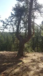
Here I'll show one. The burnt tree lines up thru the uprights at 150 degrees over to a covered mine a few hundred feet away. You will find other forked trees near the mine site. There is a limb protruding from the center of the uprights that points out a triangle of boulders about a 100 feet away slightly off to the left and down. So I'll surmise that thru the uprights go the mine, the side limb pointers go to the caches sites at least on some of the older trees.
20150215_124240.jpg20150222_114331.jpg I found this location on google earth btw because of a fault/mineralization /dike zone that was visible on google earth. Looks like a faint line cutting through the topography. Just one more tool you can use.
 

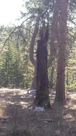
Btw you can also call the forked trees a "witching tree" because they look like the old witching sticks the old timers used. Here's the same forked tree from the side, looks like its in use lol, so bizzare.

20150215_124159.jpg
Edit , you can also now see that the previous posted picture with the burnt tree in the photo taken behind, was the only burnt tree in the area, just a different angle now that it isn't in the picture.. pretty cool, eh? Just one burnt tree on that whole hillside and it happens to line up behind the forked one.. There is also 2 tall trees out in front of the Y tree down the hill a ways that a diamond shaped rock is placed in between them that the same alignment of 150 degrees goes thru.
 

Last edited:
Btw you can also call the forked trees a "witching tree" because they look like the old witching sticks the old timers used. Here's the same forked tree from the side, looks like its in use lol, so bizzare.

View attachment 1547804
Edit , you can also now see that the previous posted picture with the burnt tree in the photo taken behind, was the only burnt tree in the area, just a different angle now that it isn't in the picture.. pretty cool, eh? Just one burnt tree on that whole hillside and it happens to line up behind the forked one.. There is also 2 tall trees out in front of the Y tree down the hill a ways that a diamond shaped rock is placed in between them that the same alignment of 150 degrees goes thru.


Q,..you may be looking at this alignment the wrong way. Similar to looking through binoculars through the large lens and focus through the eye piece…lol. No offense.

“There is also 2 tall trees out in front of the Y tree down the hill a ways that a diamond shaped rock is placed in between them that the same alignment of 150 degrees goes thru.”

Take your observation IN REVERSE and wind up On Top of the Hill at your Y tree marker. You may be on to something, this way.

Is your Y tree leaning S-SE..?

( I would forget about old capped off or sealed mines. This smells like an older M/O)
Do you know who forgot their gloves and shovel by your tree? Lol (joke, hey)


But, from the shovel w/ gloves, at your eye level…there’s a discreeeeeete #4 carved for your eyes only. (seriously) (‘bout a foot down from the branch)
And, I think you know what that means.
 

Last edited:
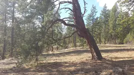
Yeah I checked the backside on that when I was there as 330 is more common than 150 (opposites on a compass). (the Y tree is leaning towards the 150 degrees and they liked the 15 degree increment stuff , so the tree markers work if you know the bearings that were used alot) But there are boulder markers out in front, along with the mine spot further out , so it seems fairly straight forward. Haven't been back there in a while, the mine was just inside native lands, I couldn't really do anything there for profit I thought.
 

Last edited:
I would take a better "look" at the tree. That IS your Cup of coffee. (boulders, mines, NA lands....I think you're past that Hike)
End of journey at the top. lol. has a good ring to it. no?
 

I actually ran a detector on spots on the backside when i was there, certainly possible for an extra cache. But the main ones go thru the uprights. Ive been to a couple like this one, especially easy to find the backfilled mines. The Y tree is right by a trail as many markers are done to point to something just a ways off the main trail
 

OOOk.,have your kind of fun. happy safe trails. (sorry to bother you)

(must add:..no sarcasm here, none)
 

Last edited:
Im just being honest, man. Not interested in knocking anything you have to say. Dont read too much into it please.
 

Im just being honest, man. Not interested in knocking anything you have to say. Dont read too much into it please.

hey hey,..it's cool bro. No kiddie stuff here, don't worry. I know you're being honest and see things your way. Cool
 

At some point we are all in this together They're just side of trail markers one way or the other, back, side, thru. But to recognize them is most important right now.
 

Here I'll show one. The burnt tree lines up thru the uprights at 150 degrees over to a covered mine a few hundred feet away. You will find other forked trees near the mine site....
How about a photo of the "covered mine"?
 

Ok guys get out of the clouds, I need some information. Do any of you know when the KGC became the OAK? Was there a year or event that one could say "This is the time when?". And does anyone know if they still use the OAK name or are they something else now? The reason I ask is that Mark60 has an area where a burned tree is in a very strategic location. The only one in that area like it. My partners and I have come across the same thing, the trees don't look to be very old, maybe 40 to 50 years old when cut. On a bluff with signs is a turkey, clearly a KGC sign then on the same bluff down closer to the main signs is the word OAK hidden in plain site. Now if there is a chance that some one might be keeping an eye on this one he needs to be aware in case their coming back. Would appreciate your help and thanks in advance. Rebelsmom

Rebelsmom, here's a interesting link posted by Texas Jay on the KGC thread it touchs on the burnt trees briefly but doesnt get into detail but it's still a great read

https://lifedeathiron.com/tag/confederate-guerrillas/
 

T.Jay has a lot of boots-on-the-ground time. Besides ample, ample research and cross reference study. He may be the Go-to, guy.
 

How about a photo of the "covered mine"?
I'm not sure I have one of it. I think it had a short trench leading to a depression or pile. I have posted another before like it though that was found following markers from a trail, it had a forked tree near it as well. If you look around in ProspectorMikels thread I think I posted it there. I think I've showed enough stuff though, most of these pictures of markers around sites are very recognizable to others that know about them, so the more you post, the better chance your places in the field go to pot. Especially if you believe in sentinels. If someone posted a random picture of any good marker of one of my sites I'd immediately recognize it and where it was taken at. Post something out west with a good wide view of the area and unique features, I can sometimes pull it up on Google earth. Anyone can. I've done it to people on this board and warned them of it when it's one of those type of photos.
 

I'm not sure I have one of it. I think it had a short trench leading to a depression or pile. I have posted another before like it though that was found following markers from a trail, it had a forked tree near it as well. If you look around in ProspectorMikels thread I think I posted it there. I think I've showed enough stuff though, most of these pictures of markers around sites are very recognizable to others that know about them, so the more you post, the better chance your places in the field go to pot. Especially if you believe in sentinels. If someone posted a random picture of any good marker of one of my sites I'd immediately recognize it and where it was taken at. Post something out west with a good wide view of the area and unique features, I can sometimes pull it up on Google earth. Anyone can. I've done it to people on this board and warned them of it when it's one of those type of photos.

Uh huh.
 

Top Member Reactions

Users who are viewing this thread

Back
Top