1856 Map... What does SM mean?

I’d guess in your instance, it’s likely referring to “Bench Mark” the numbers either being the elevation, or the name of the survey monument.

B636AF00-D977-45F9-B609-FA6E0574B089.jpeg

In this case it’s a triangulation survey marker located at the top of a mountain.
 

Last edited:
BM stands for Boundary Marker. SM stands for Survey Marker.
 

Last edited:
I’d have to respectfully disagree.
When any of the following have a third order or better elevation assigned AND are monumented with a tablet, they are labeled as “BM” (bench mark);

1.) Boundary monuments (square with dot)
2.) Horizontal control (triangle)
3.) Vertical control ( x )

It’s the vertical elevation aspect that triggers the annotation.
Boundary monuments don’t typically have elevations assigned, nor are they usually numbered.

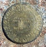
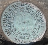
Here is what you will typically find at one of those locations labeled “BM”...at least that’s been my experience. Note “B.M.” embossed on the first tablet.

C2CB3892-86B9-4AAE-A472-D6794643237C.jpeg

1ABAD5A9-0652-4240-AE71-6DC84EDBB8C4.jpeg
 

Last edited:
I’d guess in your instance, it’s likely referring to “Bench Mark” the numbers either being the elevation, or the name of the survey monument.

View attachment 1880139

In this case it’s a triangulation survey marker located at the top of a mountain.
Looks like the 5684 is the elevation since the contour lines downslope show 5000 and 4500.
Jon 8-) :cat: :occasion14: :headbang:
 

What about Gold Mine and Silver Mine ?
 

Top Member Reactions

Users who are viewing this thread

Back
Top