geology of ky .

rgb1

Sr. Member
Nov 24, 2013
295
769
s.w. Ohio
Detector(s) used
2 whites 1 garett
Primary Interest:
All Treasure Hunting
as you all know i am not an e and are only my deucated geologist , any thing i know in regards to this theory is self taught and only my conclusions please keep an open mind then at the end believe or disbelive make your own conclusions the followering is my 2 cents worth . as i try to put 2&2 together and read between the lines of the geology of ky. we all know many eastern states were at one time were under water this is proved by the massive limestone deposits ,most have read according to geologists and geological reports the appalation mts. were supposed to be higher than the alps. the reports state because of erosion they wore down and eventually created the pene naula of florida and left DISAGREEthe appallation mts. as we know them today . [ I TOTALLY DISAGREE ] THIS IS WHAT I BELIEVE AND IS MY THEORY AND IS WHY SILVER AND GOLD IS FOUND IN KY. AND BORDERING STATES. we start with the tectonic plate movements into the western u.s, coast line , this created the rocky mtns. the seria nevedas and others this also caused many fault lines giveing avenues for the magmatic waters to accend uppwards to deposit the known deposits of precious metals at the same time creating an overthrust belt and forming the st. andreas fault line thru california during this period i belive the forces were so great they actually pushed the entire continent of the us upon an eastern plate at this time the the area of the east being under water there were many faults created for salt waters to decend into the depths of areas of hottre porphry depositsthis creating chlorine laden alkaline low sulfadation systems as these waters heated the clorine laden waters dissolved any precious metals avaiable as the waters accended up these being of higher specific gravity spread out over the bottom settelling into what is called manto blanket and sheet deposits . as the plate movements continued pusing the contonent east the east coast began to rise at the same time we had the glacial melt happening this brining in sediments covering organics building sandstones, slates , shales , and others when the forces were great enough forming the coal beds of the area about this same time there was minor volcanic activity these show evidence through out ky. as the movement continued itstarted to give rise tostart forming the mtn. ranges when this became high enough the currents of the glacial melt was diverted southward carring sedements and formed florida as the plates continued to move this flow was cut off finally forming our river systems as we know them today leaveing mountain ranges and valleys as they are now as this occured it created many faultsboth major and minor possibly even the new madrid fault of the mississippi valley . the precious metal deposits are found mostly at higher elevations these i have found in horozontal sheets or viens in chlorides oxides and carbonates i have found all of these formations these are what i found in the mines i found metal dectors will not find this type deposits as they are in chemical compounds . this is what i believe drained the swamp. sorry about couple of lines being messed up new computer tommorow.
 

Last edited:
rgb1 thanks for sharing that, I for one find it a very credible sequence of events. These layered chlorides, oxides and carbonates do they look a certain way? Can they be found above or below a certain layer of sediment? How do we visually identify them? Do you happen to have any close up pictures so I know what to look for? Thanks.
 

silver chlorides will usualy be light gray when you find them rub end of knife blade acrosst an area it wikk usually show a slick or waxy appeaence. oxides usually have to be roasted in open air to see metal and to my knowledge cant be detected easily until this happens carbonates will be of green and yellow looks like clay but is not this can run 80% silver and usually contains balance in gold and base metals most will be found in higher elevations although have found some in valley areas layers above have sand stones and slates above do not remember what was below guess was too excited being sedementary you could find any thing common to the area reason for different elevations is due to rise and folding of stratta.
 

Last edited:
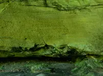
I have seen lots of green and yellow in the rock on cliff faces. I always assumed it was algae or moss causing that color. Thanks. DSCN9451.jpg
 

Last edited:
Great post very informative Im not to far from KY
 

these deposits should also be found in all the bordering states even ohio.
 

Draw you a straight line from Lover's Leap in Virginia, near where there is silver mines, thru Ingles Ferry again where there is silver mines on into Kentucky. That should give you the fault line where the silver is located, at least a general area.

My bad, I ran the line, it runs at 331 degrees NW. It takes you along a silver line but it only takes you to the silver mines near Tazewell, Virginia where counterfeit coins were made. The fault line must intersect another fault line that runs from Southern West Virginia, Southwest along the Pine Mountain Range of Kentucky.
 

Last edited:
Draw you a straight line from Lover's Leap in Virginia, near where there is silver mines, thru Ingles Ferry again where there is silver mines on into Kentucky. That should give you the fault line where the silver is located, at least a general area.

My bad, I ran the line, it runs at 331 degrees NW. It takes you along a silver line but it only takes you to the silver mines near Tazewell, Virginia where counterfeit coins were made. The fault line must intersect another fault line that runs from Southern West Virginia, Southwest along the Pine Mountain Range of Kentucky.

There is a Big Overthrust fault that runs along just inside the Ky. border from Pine Mtn. to near the southern tip of W Va.
Here is some interesting info on it.

http://www.uky.edu/KGS/education/pinemountain.htm
 

Last edited:
That is the same Thrust Line you can see on I-77 between Big Walker Tunnel and the East River Tunnel. Daniel Boone lived in this area at one time. You can see the same all the way into Tazewell Virginia. Once you cross Stony Mountain into Southern West Virginia, you will notice no more rolling hills with limestone, only sandstone out-croppings. Good Read, Ken S.
 

RGB 1: I like this theory and do not disagree with it at all. It seems like everywhere I look here in Kentucky, south central part anyway, there are fossilized sea creatures from long ago. They are just about everywhere and are abundant in quarried rock from the local area. Pyrite can be found in certain areas and, this is often found wherever gold is found. I have always thought there was "some" gold in these here parts. Of course, if I strike it rich here, I will never tell anyone, ha ha.

Bill
 

Creek rock around here is full of sea fossils, and the Falls of the Ohio has a massive area of exposed fossils all of this is in the limestone around and NE of Louisville.
 

Hey RGB is the bluish stuff we took a sample of in the huge hole some of the stuff you mentioned earlier? it had silver and platinum in it if I remember right and the yellow stuff had small amounts of gold I think you used some chloride to dissolve it out-right? This is near Carter KY.
 

hey curtis good to hear from you the stuff we collected was actually silver chloride the bluish color was caused by pt. metals the bull quartz samples were barren except for some base metals i know you thought i was wasting my time thats ok most do criticize when i ust to take samples probably a few miles from there someone is going to find a quartz vein that will carry both silver and gold it also seems to me someday there will be found a pt. deposit of great importance there is none known in the us. the samples were assayed them took balance smelted them and disolved them in aqua regia them selectivly precipatated them out of solution one by one this gave each element seperate.
 

Last edited:
hey hiker it looks like you might have something good in picture will not know till you take a sample if its yellow and green inside you might have a real valuable discovery this has been known to run as much as 20,000 ozs pr ton in silverif it is a carbonate thats is what it looks like to me must take those samples if good i will show you how to work it the impurities usually are gold and base metals dont go off deep end you do not know until proven what you might have
 

hey hiker it looks like you might have something good in picture will not know till you take a sample if its yellow and green inside you might have a real valuable discovery this has been known to run as much as 20,000 ozs pr ton in silverif it is a carbonate thats is what it looks like to me must take those samples if good i will show you how to work it the impurities usually are gold and base metals dont go off deep end you do not know until proven what you might have

The picture has a carving and spray paint on a the wall that is green/yellow. It is in a medium sized rock house half way up Auxier branch/Haystack Rock area of the RRG. Smack dab in USFS land...this is why I usually think that color is moss/algae since it is in a shady and damp rock house. I could get a sample but unfortunately there won't be any mining going on there! LOL
 

Geology and geography, plus history have been three of my favorite study areas for a long time now. I always marveled at how the older rocks lots of places were on top of the newer ones. In some Virginia mountains, we found fossils at the TOP of the mountains, and 30 miles due east, volcanic granites and precious metals associated with them and metamorphic rocks.

Where I live, it's metamorphic schist, with ultramafic rocks nearby with others hydrated to form serpentines. And layered in the creeks are a few fossils and sedimentary layers of two things: crushed pulverized limestones, cambrian in nature and sand! Some of the sand has been morphed into quartz, you can see the now cooked quartz through some of the metamorphic boulders, laid down as sand then cooked to quartz.

It's like someone took a bucket and put all of the above in it, added water (to form the serpentines) and shook and then just threw it out.

But Wait! Having seen the OLD rocks on top of the NEW ones, only one thing came to mind. Great Flood. My 2 cents.
 

About time someone got it right.:notworthy:
 

There is a guy who is a self taught geologist on YouTube who has some of the most interesting theories I have ever come across. We always hear of the gradual drip drip erosive effect that creates these beautiful rock formations over millions of years...he has a completely different approach to geology. His name is Randall Carlson, and he believes much of what has happened on Earth has come from comets and meteors and these things happen in long cycles (1000s of years) . Here is one of his presentations on the Carolina Bays. Rabbit hole alert! He has many many hours of video published on YouTube. Please check it out...every wonder why rivers only occupy 1/10 of a river valley's volume? Or why the the oceans depth has increased by 300-400ft in the last 10,000 years? You'll have to watch his stuff to see his alternative theories.


List of his videos on YouTube:

https://www.youtube.com/user/YSIproductions/videos
 

Last edited:
i notice in replies some of you think the blanket and sheet deposits are dependent on existing faults, they are not these deposits were formed whilestill under water long before the mountain building began and were created in place before this happened when the uplift happened it placed them where they are todayand can be found through out the areas ofeastern states the problem is recognition by the layman when in the field . even the geologist missed themin there so called studies
 

Top Member Reactions

Users who are viewing this thread

Back
Top