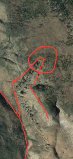
The lost Dutchman’s gold mine location

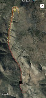
That map is the oldest historical map left behind by the Spaniards who occupied the mountain top. How lucky! That someone found it! And used it as a book cover! Amazing discoveries! That is the trail way that the Spaniards used coming down the ridge top towards the east to get to the goldmine. Well! Look at that it goes right into the horse’s mouth! Since your using the satellite right now, I hope you can spot the cotton wood stand that Jacob used to sleep in while spying on the rock horse canyon. It’s still there after more than a hundred and fifty years. That is a well made stand. Let me know when you see it? Or do I have to pointed out to you also?
 

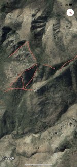
Well, like I said before, it makes no sense not to follow a map or to understand that the needle left side points to the saddle in the east on top of the Sierra Ancha mountain range just as Jacob Waltz drew it on his doodle map and now that you have informed that there is another old Templar map, you still don’t believe in that. Those of you who don’t ask to know more know what I mean, but some of you need to shown more proof of the actual place so from now on I will just post the photos of what these maps are talking about. Let’s start with the first map, again! You don’t have to put on your boots, but you will have to use the satellite to get there.
Ramiro,

I found the place in the photo. I won't post the GPS coordinates. However, I did attach an image I copied from Google Earth. It is similar to the one you posted.

This definitely not where I have been looking or were I expected the mine to be located. I am curious as to why you think this is the place. All the stories and clues I have read or heard about, none of them lead you to this area.

I really do hope you or someone finds the mine. If you do end up finding it out there, I hope you will post more pictures and information that lead you to this location.

The Best of Luck!

EDN
 

Attachments

  • Ramiro Valdez.jpg
    Ramiro Valdez.jpg
    156.7 KB · Views: 118
The mine is located just south of the Salt River, and west of 80, but there is placer gold in a few places nearby in lower washes, and also just north of the river. What looks like the mine entrance, looks inaccessible without some intense labor, and actually looks like it caved in, perhaps. There are signs, such as tailings, quartz(?) veins, and other evidence of an old mine in the area, but obviously the entrance is well hidden or covered up, and will be very difficult to find and dig out.
 

If you dare to go to the saddle’s high point located on top of the Sierra Ancha mountain ridge you will understand the satellite photo that I’m posting and when you get a good look of what I’m posting you will then understand Jacob waltz’s second doodle that he drew for you describing the high point of the saddle. From there you can use your telescope to find the needle so you can compare the way the needle looks in reference to his drawing.
 

Attachments

  • A167CDBC-28CC-440C-9AB6-F565CCAEA6D3.jpeg
    A167CDBC-28CC-440C-9AB6-F565CCAEA6D3.jpeg
    375.5 KB · Views: 98
  • 771D98CF-5E23-46EB-97D1-C086C5091375.png
    771D98CF-5E23-46EB-97D1-C086C5091375.png
    247.4 KB · Views: 96
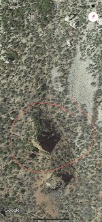
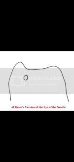
The third of Jacob Waltz’s doodle is an easy one to locate. It’s a very historical place for the Indians because the Indians usually went north to the mountains for the winter. When they came down from the north to spy on the rock horse area they would slide down a hill behind a rock structure which had an open hole that could see the surrounding area of the rock horse area. Jacob Waltz called it the eye and it was very important that you paid attention to the eye or else you could be captured by the Indians. The eye has nothing to do with the needle or miners needle. It is a small rock structure located towards the northwest from the horse’s mouth. You have to get behind the eye like your looking through it to see the outline of two drawing that Jacob drew. The satellite defines what it looks like by the shadow imprint on the ground. Here is the two drawings and the satellite photo.
 

Attachments

  • 4F10C622-2DF4-4EAC-B8AF-77A7C48A29EE.jpeg
    4F10C622-2DF4-4EAC-B8AF-77A7C48A29EE.jpeg
    414.6 KB · Views: 126
  • 5242F083-C08D-47E2-82AA-A80FE416EDC6.png
    5242F083-C08D-47E2-82AA-A80FE416EDC6.png
    62.5 KB · Views: 120
  • FC8FE838-DF03-4626-AB27-22D870C90745.png
    FC8FE838-DF03-4626-AB27-22D870C90745.png
    140.2 KB · Views: 130
The third of Jacob Waltz’s doodle is an easy one to locate. It’s a very historical place for the Indians because the Indians usually went north to the mountains for the winter. When they came down from the north to spy on the rock horse area they would slide down a hill behind a rock structure which had an open hole that could see the surrounding area of the rock horse area. Jacob Waltz called it the eye and it was very important that you paid attention to the eye or else you could be captured by the Indians. The eye has nothing to do with the needle or miners needle. It is a small rock structure located towards the northwest from the horse’s mouth. You have to get behind the eye like your looking through it to see the outline of two drawing that Jacob drew. The satellite defines what it looks like by the shadow imprint on the ground. Here is the two drawings and the satellite
The eye of the needle.
 

Attachments

  • unnamed.jpg
    unnamed.jpg
    9.4 KB · Views: 77
The eye of the needle.


Nice! Photo! Very similar and it’s a good possibility that it could be the same structure. Looks like a very close photo from behind the eye. As the elevation goes up on its right side there are several rock structures and that may very well be them. We can only hope for other adventurers to go out there and provide us with other photos. Roberts! You are an instigator! I like that! Could you tell us again for the second time, the history of your photo? If you don’t mind?
 

Nice! Photo! Very similar and it’s a good possibility that it could be the same structure. Looks like a very close photo from behind the eye. As the elevation goes up on its right side there are several rock structures and that may very well be them. We can only hope for other adventurers to go out there and provide us with other photos. Roberts! You are an instigator! I like that! Could you tell us again for the second time, the history of your photo? If you don’t mind?
Ramiro,

Some 40 plus years ago, Clay Worst and I were camped for several days nearby the landmark with the eye. We knew of this landmark from some of the first searchers for the LDM.
Gottfreid Petrasch had his camp on a mountain at the head of the canyon near to where the landmark is located.
Petrasch's camp was far off the beaten path and picked for a reason. Herman was with him in that camp for a time.
 

Attachments

  • unnamed.jpg
    unnamed.jpg
    9.4 KB · Views: 39
I
Ramiro,

Some 40 plus years ago, Clay Worst and I were camped for several days nearby the landmark with the eye. We knew of this landmark from some of the first searchers for the LDM.
Gottfreid Petrasch had his camp on a mountain at the head of the canyon near to where the landmark is located.
Petrasch's camp was far off the beaten path and picked for a reason. Herman was with him in that camp for a time.


Roberts, Is this the same eye that I posted or is this a different eye in another area?
 

Jacob Waltz described a gorge when you went over the ridge that you had to cross before entering the summit in order to climb up to the rock horse area. Yesterday I saw Ray Howland cipher map the eye of the needle and I know that many believe that he never found the LDM. Although his map describes an area where the eye was supposed to be. The gorge is a place that collect mud and it’s mainly described as a dark black area. Looking at Ray’s map I spotted black round spotted area on his trail map pertaining to the gorge. The gorge usually has a natural water drain that leads into the gorge and the excess water may exit out into another drain. The Templars maps uses iconic rock structures and natural water drains as trails cause they don’t change much in appearance for a long time. I know this and Ray’s map has the eye of the needle plus the outline of the water drain trail that runs into the gorge. The map maker was someone who learned about ciphering from the Templar maps or stone maps. Templar maps are supposed to make you think about an adjustment that has to be made to make things right and that’s why your supposed to carry a compass at all times. The trail has to look very similar to the actual trail but not perfect. You won’t find many trails that look alike but some do. What will define the trail, if you have two similar trails, will be the additional important added information that you will find on the trail that is on your map. Ray’s map has the eye, so the eye must be on the actual trail and Ray’s map has the location of the gorge. Two very important symbolic symbols that will make this map true to the area that your looking at and because the Dutchman describes many other clues, to be located near the clues that you have we on your map, one should not worry too much cause the other clues that are located near by will enforce the clues on your map. There are lots of clues to this story and all of them will be found close to each other and the reason why is because they are supposed to identify the area that you are looking for. You don’t need to define all the clues you just need to define enough clues that describe the area so you can find the goldmine. In this case you need to define a descent amount of clues within reason so you can continue locating the goldmine. If you cannot find enough clues then your probably in the wrong area. Some people think that I got lucky and found a magical place has helped me connect a good number of clues, but that’s not true because that doesn’t make sense I can assure you that if you describe what is in your house I could not find the same thing in another house? It just doesn’t make sense. That is the reason why I try to define as many clues as I can for you! If I wanted to find the goldmine myself I wouldn’t had to find this many clues. I would have been on the wall climbing into the goldmine. So think about Ray’s map and the photos I’m going to post and I hope that you don’t doubt the area if your truly searching for the goldmine. Be safe! Be cautious! Watch yourself! Because I’m only posting photos the rest of the way and you figure them out!
 

Attachments

  • ABBC61C4-7116-448A-89D7-B1C6D605AA32.jpeg
    ABBC61C4-7116-448A-89D7-B1C6D605AA32.jpeg
    292.3 KB · Views: 100
I


Roberts, Is this the same eye that I posted or is this a different eye in another area?
Ramiro,

This eye is not the one you posted earlier but is the one depicted on the drawing Waltz made in 1891.
Your eye is a spire formation and looks nothing like the drawing as seen from the ground.
 

Last edited:
The battle of the eyes, when someone goes there and sends us a close up photo from behind the eye I posted we will know for sure that it is spired as the shadow that you see. Let’s not be too hasty on what the eye really looks like from satellite view.
 

I'm planning one final trip back to the mine. I will take photos this time of the area and surrounding evidence of gold and markings showing 'human' excavations were done in the area. Maybe a GPS lock on the exact area. I am hoping to bring back some gold though, no matter how small amount it may be.
 

Well, like I said before, it makes no sense not to follow a map or to understand that the needle left side points to the saddle in the east on top of the Sierra Ancha mountain range just as Jacob Waltz drew it on his doodle map and now that you have informed that there is another old Templar map, you still don’t believe in that. Those of you who don’t ask to know more know what I mean, but some of you need to shown more proof of the actual place so from now on I will just post the photos of what these maps are talking about. Let’s start with the first map, again! You don’t have to put on your boots, but you will have to use the satellite to get there.

Ramiro Valdez

I see your location - as I've spotted it on GE. What makes you think, THAT'S the LDM area/zone? I've noticed a lot of work (mining) in that surrounding area, and to think NO ONE has noticed YOUR area - seems hard to believe. I'm not discounting your theory, but I am questioning your elements of clues that got you there. This as opposed to the Superstition Mountains area(s).

-SPARTANOC
 

The location of the horse head and neck was described on the Julia Thomas cipher map. The trail Apache trail on the map came down from the north which followed the Salt River valley. Th needle was used to point as a directional pointer pointing towards the northeast across the Salt River Valley. It pointed towards the thunder god mountain saddle peak located on the Sierra Ancha mountain highest peak. From that peak you could see the needle across the River Valley towards the west and the four peaks towards the northwest. There once was a Spaniard fort in that same location. Getting to the peak was the most important thing because the horses head and neck plus goldmine was hidden on the eastern side summit where you could spot it from the peak. That was Apache dangerous territory and you could claim that mine. It is located on the horses mouth. During the day the sunlight exposes the face of the mine and the sun also peaks in the funnel shape entry of the only sunken hidden canyon. The priest on the stone referenced the specific sea level of 1847 because its not on the saddle peak it on the Eastern summit. The true needle’s eye is located on the summit also towards the north. The priest gave away the direction and sea level elevation to get you in the area of location. It is in fact well hidden. There are two funnel shape entrances, but the goldmine is still well hidden on the ledge of the most northern funnel. To get to the ledge you have to find it on the wooded are south of the ledge. Jacob Waltz was across the top of the funnel over looking at the ledge when he shot the two Mexican Indian natives. The face of the mine is defined on Julia’s Thomas stone map at the top there is a circular looking face which should be visible from the peak. The ciphers were very well though off and they were made to deceive those who do not understand cipher symbolic symbols. They had to use several maps to get you there. I don’t really care who finds it, but I do appreciate your interest and the cotton wood stand that Jacob used to use today on the mine is still there as you come down the mountain range. If you want to be a better treasure hunter you should study the maps
 

The location of the horse head and neck was described on the Julia Thomas cipher map. The trail Apache trail on the map came down from the north which followed the Salt River valley. Th needle was used to point as a directional pointer pointing towards the northeast across the Salt River Valley. It pointed towards the thunder god mountain saddle peak located on the Sierra Ancha mountain highest peak. From that peak you could see the needle across the River Valley towards the west and the four peaks towards the northwest. There once was a Spaniard fort in that same location. Getting to the peak was the most important thing because the horses head and neck plus goldmine was hidden on the eastern side summit where you could spot it from the peak. That was Apache dangerous territory and you could claim that mine. It is located on the horses mouth. During the day the sunlight exposes the face of the mine and the sun also peaks in the funnel shape entry of the only sunken hidden canyon. The priest on the stone referenced the specific sea level of 1847 because its not on the saddle peak it on the Eastern summit. The true needle’s eye is located on the summit also towards the north. The priest gave away the direction and sea level elevation to get you in the area of location. It is in fact well hidden. There are two funnel shape entrances, but the goldmine is still well hidden on the ledge of the most northern funnel. To get to the ledge you have to find it on the wooded are south of the ledge. Jacob Waltz was across the top of the funnel over looking at the ledge when he shot the two Mexican Indian natives. The face of the mine is defined on Julia’s Thomas stone map at the top there is a circular looking face which should be visible from the peak. The ciphers were very well though off and they were made to deceive those who do not understand cipher symbolic symbols. They had to use several maps to get you there. I don’t really care who finds it, but I do appreciate your interest and the cotton wood stand that Jacob used to use today on the mine is still there as you come down the mountain range. If you want to be a better treasure hunter you should study the maps
 

Attachments

  • IMG_0623.jpeg
    IMG_0623.jpeg
    97.4 KB · Views: 45
Spartanoc :

For those who asked and are seriously looking for the goldmine. The question was how did I come to the conclusion that the Lost Dutchman’s goldmine is hidden on the eastern summit of the Sierra Ancha mountain range? Not everyone loves history like I do and history combined with all the information brought forward by the many individuals that contributed to the many unresolved treasures, including this one, help in deciphering different types of ciphered treasure maps. My knowledge first started in 2015 by deciphering a symbolic Templars goblet with history of Scotland in the late 13th century. From there everything snowballed starting with old 18th century treasure in the pacific followed by treasures in the Indian Ocean treasures, treasures in Texas, the Beale treasures, the lost Dutchman’s goldmine, Otto Hillig coin treasure, the Nazi Lue cipher treasure map, Dutch Shultz, and Oak Island treasure. There are about five other treasures maybe six that I won’t mention. Now! I know that some of you just want the location and some of you want to know more of the cipher map to make sure you don’t waist time or a lot of money looking for it? I understand the situation at hand. So, because I know the deception that comes with a cipher map, I’m going to caution you to not look for the treasure if you do not believe in cipher maps. Just about 99 percent of the treasures that have not been found have to do with cipher maps. Those who proceed and don’t believe are going to be easily deceive. There are two other options that will help you. One is if someone tells you the location of the goldmine and the other one has to do with luck. Learning to decipher the map is going to be the better option. That is the option that I take but it’s not easy. It takes a while and if you have enough knowledge of ciphering? You can do it! so I’m going to decipher in better detail based on my knowledge the part of the lost goldmine story that lead to the location because the last gentleman treasure hunter asked for it. In order for someone to act on something that he is uncertain off, it’s better to have a better understanding and I concur! If you have the time I’ll get to that soon!
There is a treasure in the Sierra Ancha mountains, But not the LDM.
 

in a a sense? That is good information for a miner who’s looking for gold there. That should make miners feel more at home knowing that someone has been there. So the museum expert of the cipher stones in Arizona superstitious mountains agreed that the cipher stones are in fact precise and it’s true! So, if the stones are precise and you can’t find the goldmine? That would identify the cipher reader as not have enough training to decipher the stones. The truth is that Julia’s cipher stone map, which was given to her by Jacob Waltz was actually discovered by a Peralta family member. That specific stone map, Jacob’s verbal cipher messages included his three doodle maps, the rest of the stones are in fact precise in the cipher sense. So the gentleman is asking is how do you interpret the ciphers so he doesn’t go the wrong in search of the lost Dutchman’s goldmine? He specifically wants to know more of the cipher in order to feel confident in his search? He is a smart miner! It’s easier to be taught tgan to learn it the hard way. If you like history combined with mystery, your going to half to read history of the Spaniards occupation in Arizona, History of the priest who wore the black robe, the two destructions of the church of Santa Fe before Mexico won their independence, the years following their independence, the Thomas Beale treasure story and history of the year 1817 through the year 1822 and combined that with the knowledge of ciphering pertaining to the secret societies plus much more history in order to understand the whole story of the Apache hidden goldmine. I know that most miners don’t care about history, so they can’t complain with the failure of not finding the goldmine. So it is smarter to ask someone who knows more? Especially when dealing with ciphers. The ciphers knowledge has been past down through centuries. Its use is mainly apply to keep something very special a secret. Most simple mind individuals do not have use for it plus you have to be taught to use it and you can only get that type of old training from a secret society or church priest that keep the old writings on ciphers which were stole by the Germans who put it to their use when the hide all their treasures. Since the Germans lost the war, all that knowledge became lost plus if you don’t regularly use it you loose it. The secret societies were getting very thin in the 19th century loosing a lot of knowledge concerning ciphers. Same thing happened to the Templars. But there is no reason why not to reinstate some of that knowledge here to help the gentlemen find the goldmine.
 

Spartanoc :

For those who asked and are seriously looking for the goldmine. The question was how did I come to the conclusion that the Lost Dutchman’s goldmine is hidden on the eastern summit of the Sierra Ancha mountain range? Not everyone loves history like I do and history combined with all the information brought forward by the many individuals that contributed to the many unresolved treasures, including this one, help in deciphering different types of ciphered treasure maps. My knowledge first started in 2015 by deciphering a symbolic Templars goblet with history of Scotland in the late 13th century. From there everything snowballed starting with old 18th century treasure in the pacific followed by treasures in the Indian Ocean treasures, treasures in Texas, the Beale treasures, the lost Dutchman’s goldmine, Otto Hillig coin treasure, the Nazi Lue cipher treasure map, Dutch Shultz, and Oak Island treasure. There are about five other treasures maybe six that I won’t mention. Now! I know that some of you just want the location and some of you want to know more of the cipher map to make sure you don’t waist time or a lot of money looking for it? I understand the situation at hand. So, because I know the deception that comes with a cipher map, I’m going to caution you to not look for the treasure if you do not believe in cipher maps. Just about 99 percent of the treasures that have not been found have to do with cipher maps. Those who proceed and don’t believe are going to be easily deceive. There are two other options that will help you. One is if someone tells you the location of the goldmine and the other one has to do with luck. Learning to decipher the map is going to be the better option. That is the option that I take but it’s not easy. It takes a while and if you have enough knowledge of ciphering? You can do it! so I’m going to decipher in better detail based on my knowledge the part of the lost goldmine story that lead to the location because the last gentleman treasure hunter asked for it. In order for someone to act on something that he is uncertain off, it’s better to have a better understanding and I concur! If you have the time I’ll get to that soon!

in a a sense? That is good information for a miner who’s looking for gold there. That should make miners feel more at home knowing that someone has been there. So the museum expert of the cipher stones in Arizona superstitious mountains agreed that the cipher stones are in fact precise and it’s true! So, if the stones are precise and you can’t find the goldmine? That would identify the cipher reader as not have enough training to decipher the stones. The truth is that Julia’s cipher stone map, which was given to her by Jacob Waltz was actually discovered by a Peralta family member. That specific stone map, Jacob’s verbal cipher messages included his three doodle maps, the rest of the stones are in fact precise in the cipher sense. So the gentleman is asking is how do you interpret the ciphers so he doesn’t go the wrong in search of the lost Dutchman’s goldmine? He specifically wants to know more of the cipher in order to feel confident in his search? He is a smart miner! It’s easier to be taught tgan to learn it the hard way. If you like history combined with mystery, your going to half to read history of the Spaniards occupation in Arizona, History of the priest who wore the black robe, the two destructions of the church of Santa Fe before Mexico won their independence, the years following their independence, the Thomas Beale treasure story and history of the year 1817 through the year 1822 and combined that with the knowledge of ciphering pertaining to the secret societies plus much more history in order to understand the whole story of the Apache hidden goldmine. I know that most miners don’t care about history, so they can’t complain with the failure of not finding the goldmine. So it is smarter to ask someone who knows more? Especially when dealing with ciphers. The ciphers knowledge has been past down through centuries. Its use is mainly apply to keep something very special a secret. Most simple mind individuals do not have use for it plus you have to be taught to use it and you can only get that type of old training from a secret society or church priest that keep the old writings on ciphers which were stole by the Germans who put it to their use when the hide all their treasures. Since the Germans lost the war, all that knowledge became lost plus if you don’t regularly use it you loose it. The secret societies were getting very thin in the 19th century loosing a lot of knowledge concerning ciphers. Same thing happened to the Templars. But there is no reason why not to reinstate some of that knowledge here to help the gentlemen find the goldmine.

Ramiro Valdez
I think for now, I'd have to side with Doc4261. The possible Mine you are referring to is not the LDM. Of course, I can't be definitive about my decision, but there's just not enough clues/evidence that would match what Jacob had stated AND the info Julia was given. In your statement, you keep mentioning 'Julia' cipher stone map'. I don't recall Julia EVER having access to any Stone Map of any kind. She was given a map, as Jacob drew his path and clues in a doodle more or less. She was never given a stone map. In fact, the Peralta Stone maps were found at a different time period, in a different location to where Jacob resided/mined in. What I understand is, there are maps and then there are the Peralta Stone Maps. Could the Stone maps AND the drawn maps lead you to similar areas/mines? It's possible. But as for the LDM itself - that location I believe is still the Superstition Mountains. There's just too much that says - the LDM and other possible Spanish Mines are in the vicinity of the Supes, not North of it. Even if you took all the maps (fake or not) and followed the clues/monuments/past diggings, things STILL point to the Supes being the holder of most Mines - including the LDM.

Now, that all being said, the area that you've brought to light, is an interesting area/mountain. In viewing GE on said mountain (Sierra Ancha Mountains - east side), I do see some spots on the ridge that resemble some type of indentation/impression that is sunken down like a funnel shaped cone (see attached screenshots). I can't verify if that's natural or manipulated ground - as GE doesn't play nice when it comes to details. IMHO, I believe either the Spaniards or going back further in respect of the Aztecs, were in the area in question - but to say Jacob made his way into this area, is stretching things. With all the clues I've read, in regards to what Jacob mentioned, to Julia and others don't seem to fit this exact area. Could it be another Peralta Mine? Quite possibly. Could it be workings by the Spaniards, could very well be, but to try and match the area in question by the statements of Jacob, Julia, and all the others involved doesn't seem to be a conclusion we're all looking for. There is evidence of a type of structure on the South base side of said mountain, though it does look more modern than other remnants I've seen around in the Arizona highlands. The East area of the Mountain is pretty remote and rugged and would take a considerable amount of effort and time to reach any peak or ridge and I'm not sure you could take a mule or burrow up into those ridges. I would suspect it would be treacherous for a person let alone a mule up in the sheer and steep cliffs of the East side or anywhere on that Mountain. Plus, I'm not sure Waltz could have made that trip once let alone twice.

In recent times, I've spoken to some of the 'hunters' here on TN - specifically Idahodutch. In his assessment, he's pulled the clues together, matched up areas of interest and has found certain elements of the story - to not only be true, but has allowed him to go a second time (he's going back this year), to follow up on samples. THAT is what's needed for the most part, samples. All of us on this site can say all day - "I know where and I've seen...", but nothing gets validated till there's samples of Ore and the only way that's going to happen, is to get those boots-on-the-ground.

Ramiro Valdez, I wish you the best in your searches, providing you are still on the hunt for success. I am not discounting your theories and I believe you've found an area of great interest, but as most will say here, the ones that will be successful are the ones focused on a path and not to get side tracked by other possibilities. Though your information might be valid and genuine - the story you've provided just isn't a great match to the known clues out there, for the LDM. - SPARTANOC
POSS FUNNEL MINE.PNG
INTERESTING DEPRESSION FUNNEL.PNG
 

Top Member Reactions

Users who are viewing this thread

Back
Top