LDM why you cant get it ! MAP #10

JackH

Full Member
Feb 26, 2011
211
19
Central Pennsylvania, ex SoCal
Detector(s) used
White's DFX
LDM why you can't get it ! MAP #10

Gentlemen, Ladies,
It has come to my attention that nearly 18,000 hits on my first thread has some people's interest.

Especially since my last post (#256) was April 15, 2011.

There were a few who followed their own conversation well into June 17th, 2011.

I would like to think that those who have kept that first thread "LDM why you can't get it !"
this active are interested in what I have presented & not that conversation that extended
well beyond my last post of 8450 hits. I came back last Aug to find over 16,000 hits and
kept an eye on the count. We should hit 18,000 by the first of the year, and I have felt
that I needed to clean up my act in a few areas.

First I want to break down that thread into the individual Maps, this being the first of that,
my second thread.

I have gone back several times to fine tune Map #10 on the old thread post #195 page 10
and decided to carry it over here to continue the discussion if anyone would like to do so.


Thank You for your Time and Interest,

Jack
================================================== ==============


Quote:
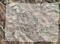
Map #10 (again),

I have come back to this Map because there is additional information to give credit to Red Mountain.

Additionally my point is Red Mountain, and little reference to the Superstitions only as viewed from a distance at a high point.

Not to repeat what has been discussed in previous posts, I refer back to post #110 Pg #6 for Map #10, and satellite image post #116

That being said:

a) Center of Map is from 4 Peaks.
b) Small circles with line extending out (tail), Peaks. Height/size of Peak in relationship to circle. Tail of circle direction in which to look,
c) Peaks drawn (as fist, index finger extended) have same shoulder (look @/towards).

Start point is small peak Stewart Mt (in line) between the two (radiating circles), one below 4 Peaks, other above MEQSA (MESA).
Radiating circles (view from this angle as an eye/eyes).

Tail pointing beneath (symbol) 4 to finger pointing (look from here "eye"), arrow curves (turn around) at 4 Peaks. The eye sees Red Mt as drawn from this view, which is in 180 deg. reverse on map.

Key is you can only see Weavers Needle from 4 Peaks, not from start point.

Wavy line from 4 Peaks (Salt River).

From 4 Peaks: Peak above Weavers Needle (between Malapais Mt & Tortilla Wells?) pointing towards correct direction, in close relationship to Needle. I believe this area would be a good spot to communicate by reflective mirror back to Red Mt or back depending on the days sun.

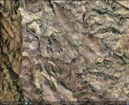
From 4 Peaks look beyond small peak: look to MEQSA (small peak in middle of MESA). adjoining Red Mountain. (Red Mountain is in 180 deg. reverse) character marks of Red Mountain reference post #110.

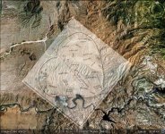
Descriptive change of the association of outcrop and Red Mountain, changes 2nd photo's accuracy and 3rd photos angle slightly.
(In this presentation I have replaced those images with new ones.) This change will bring a more accurate relationship to Map #10.

From a small peak close at hand (large hand) pointing to outcrop @ Red Mountain. Outcrop drawn on map can be found 800 yds east, down the arroyo from largest outcrop that nearly touches the arroyo @ Red Mountain.

Ancient Salt channel is long red line with slight change and back on same direction.

Above 4 Peaks on map are two small peak symbols surrounding a symbol (MMM). Look this way between the 2 peaks (b reference) to view the range/ridge line away from 4 Peaks

(IMO) There is Nothing on this Map that gives any precedence to the Superstitions, only Red Mountain, three or more times.......J


Attachments

  • map #10 illustrated.jpg
    map #10 illustrated.jpg
    81.5 KB · Views: 1,581
  • View from 4 Peaks.jpg
    View from 4 Peaks.jpg
    205.4 KB · Views: 568
  • View from high point Outcrop close at hand.jpg
    View from high point Outcrop close at hand.jpg
    254 KB · Views: 523
Last edited:
Some tips to decrypt a map with "Google Earth "
All maps are 2D and must to look vertically to the ground . After , with the clues and the map , you must match the map with the landmarks , of course from the altitude who match better . Be careful because some maps are reverse , like the " Perfil " or " Waltz " . Usually , the human face or animals on the maps , looking to the treasure . In the " Ruth-Gonzales " map "The face " look and says : " To the mountain below , between the peaks " , and in the " Peralta horse " map the treasure is in the horse mouth becouse the horse grazing south from the " river " . The word " RIO " means " river " and "reverse " in the Spanish- Mexican maps .
I hope to help you a little , and thank`s for your attention .

P.S.
I give you an example with the " Virgil Bowmen " map which you post .The map shows around to the La Barge Canyon south to Black Mountain . In most cases a letter on the map is a landmark outline .

Virgil Bowmen map verification.jpg

Have a nice day
 

Last edited:
markmar I do not at this time have the knowledge to produce an overlay.

I would like to suggest to you, to take the Map #10 and place 4 Peaks and
Red Mountain or Ancient Salt Channel beneath it and take another look...J
 

I give you a matched map . Why do you insist to other places ?. Begin to investigate the new map .

P.S.

2013 comes in few hours and I would like to wish everyone a happy new year with health , good luck , good finds and nice emotions .
 

Last edited:
please separate the two along side of each other, not layered.

I have not the talent to see what you see in this.......

thanks in adv....J
 

Map.jpg

This is the picture separated . Be patient and don`t run .
 

Markmar,

I can't help but notice that You are New to this Arena "TreasureNet".

It takes a Special willingness to Post within the Arena, usually a feeling
that overtakes you, and you have to share that Knowledge which has
come over us.

I can't say you are a Veteran of "TreasureNet", and neither am I, since
this Forum has changed when I came back. But you are on your way
to becoming one.

I would suggest to You Markmar, to start your own Thread and share
your thoughts/theory of what you have found, just as I have done and
so many others.

My Experience here has generated a powerful resolve to Prove that
theory. I could Not have done this without the negative response from
so many which eventually narrowed down to a few. A learning process
for myself as well as those willing to read and or exchange as you have
done here on this Thread.

I have come back to this Arena because the Evidence of those who
believe ? what I have to say (18,000+ hits) deserves my continued
attention to their Interest. And I have much more to offer to those
who have followed my posts. At this time, I have a half dozen Maps
that will show that "Red Mountain" is where it's at. Most Maps have
already been discussed in my first Thread, but not the depth that I
have given here on Map #10.

In Response to your Offering, & the layered image, I can only assume
that you have not read my whole first Thread, a Learning Process.
Because if you had like so many others, I believe our Exchange would
have taken a different course.

I Wish You Markmar a Grand and Prosperous New Year along with Those
who read my offerings in this never-ending Learning Process.

Please Continue.......

Jack
 

JackH

I rerspect what you believe about your maps and your opinions . I didn`t want to change what you believe about your investigation . My intervetion was becouse you tried to match a 3D picture with 2D map , which is impossible , and I wanted to bring you closer to what you looking for (ever to my opinion) . My knowledge don`t teached , is "gift " and what i will say about , can "scare " somebody .

Now about the maps which were made to find the LDM and Peralta mine . The clues are clear : 2,5 miles radius from the Sombrero Peak . Why you don`t believe that ? Why you do the easy , hard ?
I read hundred posts about and a very small percent focus to the real place ( ever to my opinion ) . Now i know why you can`t get the LDM . I could say that I know were is the LDM or Peralta mine or aztec Painted rock , but for this time I will wait , watching your progress .

Marius


P.S.

I am new in " Treasure Net ' arena but I have experience in " Life " arena . Good luck in what are you will doing in the future .
 

Last edited:
My intervetion was becouse you tried to match a 3D picture with 2D map , which is impossible

Marius,

It is not impossible, based on the interest of my first Thread.

The clues are clear : 2,5 miles radius from the Sombrero Peak . Why you don`t believe that ?

I Really Do Believe That ! El Sombrero is Red Mountain.

I read hundred posts about and a very small percent focus to the real place ( ever to my opinion ) . Now i know why you don`t get the LDM .

If you had taken the time to read through the 1st Thread like I suggested, you would have found that "No One" can have
the LDM because it belongs to the Pima-Maricopa Tribe that own's it on their Reservation. And that there is a fence around
Red Mountain keeping everyone out but their fellow Tribe Members.

Additionally the closest Members have moved away, the properties have nothing their but empty homes. I believe they were
asked to move, because Nothing was left behind but a few old appliances in a heap behind one of the properties.

Secondly, Arizona stopped giving out Mining Permits a year before I started this Project (my investigation). Last I read,
You cannot turn over a rock, dig, or use a miners pic anywhere in Arizona looking for Gold or Silver.

Sadly, You can't have it either.

watching your progress .

The Only Progress for well over a year was your first Post. I decided to carry the Subject MAP #10 onto it's own Thread
because of You & the Fact that 18,000 hits on that Thread "LDM why you can't get it !" tells me that a few people seem
to think the same way I do.

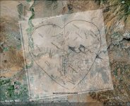
Please take a look at my Explanation of the Peralta Heart Stone. A 3D picture and a 3D rock. It is an exact duplicate of
Map #10 and the Satellite image I have Presented. You can find this on Post #130, page 7.
 

Last edited:
SOMBRERO

Andalusia - Wikipedia, the free encyclopedia

Sombrero de catite Andalusia, Spain worn by Jose' Garcia Ayola (1836-1900)

Red Mountain (El Sombrero)

A question asked of me sometime back about what I thought about the origin
of the Sombrero landmark concerning Peralta. I said it most likely would have
been General Peralta giving credit to his many Peons. But after I found this
today, I would think that Peralta may have had a link to Andalusia, Spain where
this hat originated.......J
 

Attachments

  • 481px-Chorromujo, sombrero de catite.jpg
    481px-Chorromujo, sombrero de catite.jpg
    54.9 KB · Views: 278
  • redmtn.jpg
    redmtn.jpg
    60.1 KB · Views: 323
JackH

I apologise because I used the word " Sombrero Peak ' . I mean " Weaver`s Needle"

I see your picture on Post #130, page 7. The heart looks very clear , but she haven`t the clues who give us the Peralta " Latin Heart " . Only the orientation is right (NW) . The terain is open to the spies and would very difficult to hide .


JackH heart.jpg


Or you mean this "heart " ?


JackH Heart 2.jpg


Now the orientation is wrong too . What can i say ? Are many "hearts in "Superstition Mountains " and somebody may be confused .
 

Last edited:
Marius,

I have forgotten most of which I have replied to in the first Thread "LDM why you can't get it !"
But I do retain my convictions that I am where I will stay on the satellite map for the "LDM", and
several other Maps that lead me back to the same place "Red Mountain".

You entertain me with your hard work on this subject "Lost Dutchman Mine" overlays. And You
are almost where it all comes together. Turn the whole stone with the Heart in Place, so that the
knife (Verde River) is at the top. The Heart will almost be vertical. The Map on the "Heart" shows the
relationship of where it should be in the first place, not "Clock-wise" at just past 3 o'clock. That
curved line from just below #1 means the direction has changed. That arrow on the end of the
curved line, points at a place just below 1 (below the first Peak closest to the river). Just above
that point (below #1) is the starting point of a long curved string. The string has 4 dimples along
that trail, each one hour intervals of travel between the next dimple. 4 Peaks @ 20 miles from
Red Mountain and the "X" on the left side of the string. Right side of string at this area is Red
Mountain on the arroyo side where the entrance to the LDM is and the "Omega" sign which I
believe means "Gold". The placement of the "Omega" well up along the side of Red Mountain
where the "Outcrop is also located. Additionally, the line on the left side of the string of time
travel/travel I believe is the Salt River once again. The "X" is in the same place along the Salt
as where MAP #33 shows ARRASTAS & Placeres del oro along the Salt River. That leads left
on MAP #33 to "CAMINO/AUGUA CAMINO" to "ARROYO CAVERNA" to "CASA CAVERNA".

I have on my first Thread written about where "NEGRA" is located here and the relationship
of "CERROS COLORADO" TO "NEGRA". That is my next Thread MAP #33 coming soon.

There are a few people who see "Why" I keep coming back to Red Mountain !

If you do not have MAP #33 available, I will attempt to recover it and place it here.


Thank You for the opportunity to "get back into it".......Jack
 

Attachments

  • LDM MAP #33.jpg
    LDM MAP #33.jpg
    246.1 KB · Views: 648
  • PERALTA HEART STONE enlarged.gif
    PERALTA HEART STONE enlarged.gif
    158.9 KB · Views: 412
Last edited:
Jack ,

Give me the map #33 , and i will try to resolve .

P.S.

A simple arrow show the direction to the treasure . The arch arrow means " opposite" or " reverse ". Look at www.mii.org/pdfs/legends.pdf
 

Last edited:
computer would not co-operate.

I am Not trying to Confuse you, since I have almost done
that to myself trying to include the Peralta Heart & Stone
in both positions here, but (PC) not Co-operating.
 

Attachments

  • PERALTA HEART STONE enlarged.gif
    PERALTA HEART STONE enlarged.gif
    170.3 KB · Views: 590
  • LDM MAP #33.jpg
    LDM MAP #33.jpg
    257.1 KB · Views: 576
Last edited:
Never mind , anyway do not match .
I want to tell you my opinion about the knife on the Peralta stone map , the Peralta stones trail and Peralta whitch stone map . The knife means "trail " and have two parts : the handle ( who help us to cut ) and the blade ( who is the important tool to cut ) . The arrow on the Peralta knife show us how after half of way the trail run East and " tell " us : "After the first map ( number #1 ) the trail is easier to get the mine .
Also , the Peralta Stones trail map are two ( the " Don " and the " Cross " ) and cut the trail in the middle . And now comes the whitch and " say " : " Follow the cross map , up to the East and you find the way to the heart . The " knife ' and the "whitch " ask us to ignore the " Don " map , because is not important and was made to confuse us . The question is : were is the middle of the trail ? And now we remember the Peralta`s Clues who says how the " party" performed in a circle with 5 miles diameter and in the centre is the " Weaver`s Needle " .
Yes , my brave hunters the " Whitch " is " Weaver`s Needle " and is in the middle of the trail .

It is enough for this time . Have a nice day .

Marius
 

Last edited:
MM,

Sounds like you have it worked out pretty well. Can you tell us your source for this statement:

"And now we remember the Peralta`s Clues who says how the " party" performed in a circle with 5 miles diameter and in the centre is the " Weaver`s Needle " .

No problem if you want to keep that information to yourself........Just wondering.
:dontknow:

Thanks in advance,

Joe Ribaudo
 

Never mind , anyway do not match

Marius,

It does Match, more Perfectly than you have Missed/overlooked.

I do not use overlays. In most cases, these MAP's represent a time over 150 years
past, and some have probably been copied several times over. Direct proportions are
not going to fit in any overlay without some generosity in the relationship to the "Key"
elements of each MAP.

There are at least (8) "Key" points on this MAP #33.

But this is not the place to debate/discuss MAP #33. That is
going to be reintroduced as my next Thread "LDM why you can't get it ! MAP #33.

Jack
 

Hi jack

The " heart " map do not match with the " MINAS DEL ORO " map because the Peralta "heart " is in the Bluff Spring Mountains , and the "MINAS DEL ORO '' map cover about 240,5 square miles in the Superstition Mountains with the heart location in Black Mesa Mountain ( or Cerro Colorado ) . The only similarities is their direction ( NW ) .

The reason for not give you the " Mapa del oro " overlayered , is because the quest will be ended . The " Casa Caverna " on the map show the location of the LDM . Show the center of the " heart " .

Don`t run . Will go there using Waltz`s and Peralta`s clues . We have all the time to do this , of course if don`t find it first other hunters .

P.S.

To my opinion and investigation the LDM is not the same with Peralta mine , but are close each other . Because the " MINAS DEL ORO " map have large area to investigate , the mines looks like one . If you want, I will give you my explanation .
 

Last edited:
Hi hunters .
I supose you are in the Superstition Mountains because nobody reply to my thread . Didn't have time to tell you how in the route of the trail of the " Cross " map , is a trap . Not far before the mine is a tunel covered with a wide stone which is carved with the word " CAVERNA " . Is not the real mine . Below the trap is a stone heart which warning you . To decrypt the symbol look at Treasure Hunters University
I whish you good luck and watch your back ( and steps ).


CAVERNA   trap.jpg


P.S.

I owe you an explanation about the trap . Look the "Whitch " map . The word "COAZON " means a "broken " heart . A broken heart Warning as about a death trap . Below the word "COAZON " is a white heart with an arrow who show the place were the word is broken .The white "clear " heart means " gold " or " wealth " . This image says : " In the route to the gold is a death trap " . If you look the Heart stone map you will see a crack on the top of the left side .
And now about "CAVERNA " trap . In all cases on the maps , the words " MINE " and "GOLD " are written alone and not together (in clues not in title ). In the Peralta's latin heart map ( which give us the clues ) , the words are written together . The word who match better in the LATIN heart is the word "AURUM" . The word "CAVERNA " is the trap . An impatient hunter who search for "CAVERNA AURUM " maybe will lose his life .
Thank you for your atention .

Marius
 

Last edited:

Top Member Reactions

Users who are viewing this thread

Back
Top