Witch map's

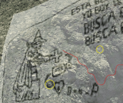
What if the witch is a mountain the cross is a wash and the words on the map are on the ground the size of a football field what could it be . I think the hat is the Sombrero mine.
Torie, have you tried to smoke that damn weed? I'm joking.

After an extended research, i found out how the Priest/Witch which is depicted on the stone tablet, it's only about 240 feet high, on a mountainside. It's shape, as the Spanish/Jesuit treasure maps rules require, is following rows of rocks on the ground, like all the other drawings/carvings on the tablet.

The Priest/Witch and the words on the tablet, as a final shape and meaning, are a result of the existing rows of rocks in the region which have helped and inspired the imagination of the map maker, nothing less and nothing more.

Actually, all the stone maps are Jesuit treasure maps to their hidden church belongings, which each one has been made for a specific spot or showing multiple spots of where the Church treasure has been buried, and there are three places where their treasure is buried.
The Priest map has depicted on it only one location of the three, the lower dot in circle, but actually was made to show and advice the way to approach another location, that at the end of the stone trail. The map shows how from a lugar to another, someoane has to follow a cross carved on a flat rock, rocks which few have confused as a grave's head monument. The priest cross, which holds in his arms, is pointing to another location of the treasure at a short distance, but also shows with the upper edge of the cross, where the trail of the 18 lugares ( cross markings ) to a different location is starting.

I post an overlay of the Priest/Witch on the ground for better understanding, and I marked two of the three location of the treasure with a yellow circle. The upper dot in circle depicted on the Priest tablet and also on the Horse tablet, is for another entrance from above to the one of the treasure's location. Enjoy!

PS
And for the Sombrero mine, IMHO is in another region to the north.
 

Attachments

  • Priest.png
    Priest.png
    428.6 KB · Views: 36
Last edited:
The picture of one of several I have found mostly silver this one gold all catamarans what do you think of water stations please tell your thoughts
 

If you know where the x on the big rock with shovel next to it as shown on us desert that would be witch mountain as in the real spirt of the now dead couple that they had hoped to have this area closed they found this place with my notes what the history Channel did not say about there satellite experiments was the hearts each one containing gold bars go to US Desert lost dutchmen my plan for years was to see there dream I will see it through a book and directions (in the book I will ? ,...)and get this place saved...
 

Torie, have you tried to smoke that damn weed? I'm joking.

After an extended research, i found out how the Priest/Witch which is depicted on the stone tablet, it's only about 240 feet high, on a mountainside. It's shape, as the Spanish/Jesuit treasure maps rules require, is following rows of rocks on the ground, like all the other drawings/carvings on the tablet.

The Priest/Witch and the words on the tablet, as a final shape and meaning, are a result of the existing rows of rocks in the region which have helped and inspired the imagination of the map maker, nothing less and nothing more.

Actually, all the stone maps are Jesuit treasure maps to their hidden church belongings, which each one has been made for a specific spot or showing multiple spots of where the Church treasure has been buried, and there are three places where their treasure is buried.
The Priest map has depicted on it only one location of the three, the lower dot in circle, but actually was made to show and advice the way to approach another location, that at the end of the stone trail. The map shows how from a lugar to another, someoane has to follow a cross carved on a flat rock, rocks which few have confused as a grave's head monument. The priest cross, which holds in his arms, is pointing to another location of the treasure at a short distance, but also shows with the upper edge of the cross, where the trail of the 18 lugares ( cross markings ) to a different location is starting.

I post an overlay of the Priest/Witch on the ground for better understanding, and I marked two of the three location of the treasure with a yellow circle. The upper dot in circle depicted on the Priest tablet and also on the Horse tablet, is for another entrance from above to the one of the treasure's location. Enjoy!

PS
And for the Sombrero mine, IMHO is in another region to the north.
This is the real pic of the Witch/Preist. I wasnt quite ready to share this but.. U Cant believe everything you read. No need for any long explanation... Just a Pic. Sometimes the simple answers are the right answers. No need to overthink it. It was meant to be found, hense why they made a map. Just gotta look in the right place.
 

Attachments

  • Screenshot_20240327-195241.png
    Screenshot_20240327-195241.png
    232.8 KB · Views: 45
Last edited:
Cochise said he spent half his life hiding thing's in Adobe one day I found a bird looking rock messed with and came to a wooden thing gave it to some one as a joke year later messing again got to wood and then a Silver necklace. I have seen people crush rocks here burn rock's to get Silver and gold here just saying...I like Silver and gold thing's better...like picture of
catamaran...2 + ounce .
 

Nice witch there is plenty of the first Aztec god looks like him I'm not a big fan of catholic priest's your's is to small...
 

The witch maps are one thing and that new thing on the history Channel that couple and hearts here is a heart or plenty on strong hold mountain az near the end camp ground there is a big rock in road stop go to right find trail if you go all the way up you will find painted rocks much like the painted rock's near superstition mountain come back down look for big rock on left with heart on it turn to the right go round the corner small heart is there gold bars on federal land ...I don't know...
 

If you take the stone maps and save the image you can overlay them onto google earth and use the ruler tools to see that a person with drafting skills made them. You will see that they used a drafting compass and a straight edge to place the carvings. I believe that the priest represents 4 Peaks mountain. It is all about triangulations. 1847 is 18 miles to the mine, 47 miles to Phoenix
 

If you use Google maps in pearce az go down dream catcher road go past road keep going straight to mountain that is witch then to the right is the writing that simple. The rose quartz gold comes from diamond mountain .I just like finding things .
 

Top Member Reactions

Users who are viewing this thread

Back
Top