West coast storms ------- Cold snow dumper followed by warm could = WATCHOUT !

It's been coming down steady all day in El Dorado County. Expecting blizzard conditions tomorrow!
 

We are getting a rare steady rainfall this week in SoCal Streets are starting to get a lot of running water on them!!
 

Here in the east, more snow. It will end by April I'm sure.
 

Right idea but IMHO but I don't think there was enough snow base to get the event you are thinking of. Might make for some messy areas and will be a PITA for some but not enough for a gold moving event.

Nice observation though
 

@ 8:35 AM 16 Jan 2019 the current Ski Resort reports show's a real mixed bag of results for snow fall in the last 24 hours and 72 hours as well as base levels:

Lowest 24hr/72hr amount = Zero Inches with a base layer of 96" minimum to 96" maximum

Highest with recent snow 24hr/72hr amount = 29"(so limited snow fall), with a base layer of 67" minimum to 107" maximum

Lowest with recent snow 24hr/72hr amount = 7", with a base layer of 20" minimum to 33" maximum

Of course if you look at the snow fall in the last 24/72 hours and add that to the minimum base layer it Never adds up to the maximum base layer amount they indicate. I would say they are estimating (guessing as to draw more people up to the mountains-maybe I'm just a skeptic but I've had it with governments and big business in the USA lying to us little folks) anyway, the results are Estimated.

IF a hot spell were to come through And it would include all of the NorCal Sierra Nevada mountains All At Once and last long enough then maybe it would do something But as the river drainage's are by a canyon to canyon basis it is impossible to tell just what could happen. Or, wait and see what actually happens as opposed to the "Science" of weather guessing! IMHO...............63bkpkr

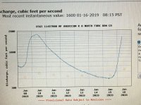
IMG_4474.JPG 9:21 PM 16 Jan 19 the NFAR flow is just short of 3000 CFS, looks like its starting to lower.
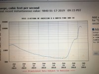
The above water flow chart from Lake Clementine along the NFAR was just downloaded, it seems to still be rising but 2000 CFS is nothing but one Heck of a Raft Ride down that river!!!!!!!!!!!!!!!!!!!!! Let's see where it tops out at! In 2017 the flow hit 50,000 CFS followed ~ 2 months later by 40,000 CFS, now That's some amount of water And Yes it Really Moved a lot of gravel/boulders/dirt and whatever else was down there AND the fish and aquatic life survived like it was normal, GEE!! I think Somebody LIED to Everyone about all the damage suction dredging does!
 

Last edited:
Drove by and over Lake Shasta in late December and my hillbilly official observation was there is room for a LOT more water!
 

its a blowin hard out there. watch out for debris and low flying waterfowl. creeks and rivers are swollen.
 

What a Difference a Day Makes like My Oh My!

IMG_4476.JPG So here is this mornings CFS flow rate for the NFAR in the Sierra Nevada Mountains out of Sacramento (California of course).
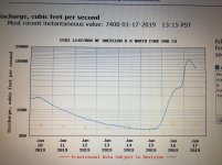
Last night around 9PM it was just below 3000 CFS and here it is this morning (now 9:53 AM) peaking at just over 11,000 CFS! I would have loved to have been camped in the canyon last night 300' or 400' or more above the sunset water level of the river as last night there had to be some crashing, banging, roaring and such going on down there! However, 11K CFS is something but not a lot as compared to 40K or 50K but, still its nothing to get caught in! Stay Safe, its winter after all!...............63bkpkr

IMG_4477.jpg So Four Hours later, it is down to ~7,040 CFS. I'd say the big dump is over unless more comes through late today??????

It is now ~ 4:00 PM 17 Jan 2018 and the CFS is at ~ 6500. It is snowing from Blue Canyon (5022' elevation) on up Highway 80, at Soda Springs (6095' Elv) the snow is heavier with more showing on Hwy 80 itself. At Dutch Flat highway 80 is wet but no snow. The area is expecting Rain/Snow as the temperature varies.

It seems like it is winter in the Sierras!
 

Last edited:
Drove by and over Lake Shasta in late December and my hillbilly official observation was there is room for a LOT more water!

Have ya ever detected it when it was low?? There's so much area there, you would have to do it like an 8 to 5 job and never cover it all.
 

T.C. - even when any location is high or low it is just SO Much area to cover by one person it would take a lifetime and still not reach it all. Of course the targets can shift some so each year any location is somewhat different especially closer to even minimally active water sources but then, a person has just got to try! Keep enjoying being out there................63bkpkr
 

Over 4" on wednesday at shasta dam and shasta rising at lakehead finally as they had 10" of rain at the forest station there-John
 

There’s more raincoming your way John. Raining like a cow peeing on a flat road over here on the coast. I’ve a 12 hour solo shift tomorrow on Hwy 199. There’ll be a lot of rocks to plow, hopefully no big slides. The Smith River is already running high and muddy. Moving some material.

Mike
 

delnorter, didn't realize uz was in flat rock cow peein country,careful where you step! :laughing7:...........63bkpkr

Thanks for the heads up! Be interesting to see what it does up NorCal way.
 

You darn right Herb, it’s not so bad those cows peeing on a flat rock, but when they crap on a good river skipping rock it’s another story. Ha ha.

Well the storm has passed and it’s beautiful up here again today. A pretty good amount of rain, about 11 inches in 4 days. Not a flood, but turned the otherwise gin clear Smith River pretty chocolate colored. There will be a little rearaingment of the gravel bars and a few slides, but not much change in the river.

Come on up this way some day Herb, we’ll do a little panning.

Mike
 

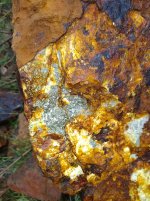
63bkpkr, I was out on NFAR just below the confluence a good ways Thursday and Friday at water level. 11,000cfm wasn't moving much. Perfect opportunity to go get an idea for what the stream is doin at 40-50,000cfm though I'll tell ya ;) now those perennial creeks & drainages on the other hand... Found this along the way, any clue as to what the hell I found? Heavy as hell. Like soaking wet in leather heavy IMG_20190117_103052108.jpg
 

Last edited:
E&C, The multicolored rock - take a magnet to it, I offer that as it may have iron in it that will attract the magnet, the red/rust color. If not magnetic then can you easily separate or cause flakes to come off of it, like peeling layers loose? If you can peel layers then possibly Mica. If a magnet clings to it then iron and if so I'd break it open as Iron might be associated with gold.

The river flow - when you say confluence do you mean the meeting of the North Fork and the Middle Fork between the new vehicle bridge and the old Train bridge?? Or elsewhere?? They may be letting Clementine Dam fill and are only letting the normal flow for this time of year exit the Dam, total guess on my part. 11,000 CFS should not be massive but it still should be noticeable.

Thank you for the input..............63bkpkr
 

Top Member Reactions

Users who are viewing this thread

Latest Discussions

Back
Top