US Govenment Removing Gold Areas from Topo Maps

Davidail

Jr. Member
Nov 3, 2012
53
12
North FL and North GA
Detector(s) used
Garrett AT Pro Metal Detector with 5" coil making it the AT gold
Primary Interest:
All Treasure Hunting
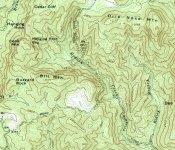
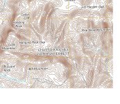
Over the Thanksgiving holidays I went prospecting in the North Ga mountains, I was in some known Good gold areas, and was taking sample from several creeks. On my last sample I had actually wondered off my map and came upon a creek crossing the National Forest Road I was on. I took the GPS Coordinates and saved them in the unit. When I got home I looked the coordinates up on a USGS 2011 Topo map, and the map didn't have the creek on it. So I thought my coordinates was off, and re-confirmed the location, which was right. I pulled out a 1961 USGS topo map same scale of the same area, and the creek was there. Not only was the creek missing, roads have been removed, Water falls and numerous tributaries to this creek. I did some research on this area and it was one of the biggest gold deposits in the North Ga area. It appears Uncle Sam doesn't want anyone finding this area with modern maps. This area is mention in the 1896 Gold Deposit of Ga. Guess my question is, has anyone else came across something like this in any areas? or states ?? I am reluctant to give out the area on a open form in that the Government may ban panning in this area. The state of Ga has already banned panning on the State Owned Wildlife areas. The area I am talking about is located in US National Forest.
 

Upvote 0
I can see from some of this post several of you mite not realize you can get USGS topo's from the USGS site for Free Most all the Maps are available for download, and they are free. Most all the Maps of Ga go back to the 1890's

The USGS Store - One stop shop for all your maps, world, United States, state, wall decor, historic, planetary, topographic, trail, hiking, foreign, satellite, digital

Another great item to have is their free program called TerraGo which allows you to take a downloaded map, and click anywhere on the map and it will take you to goggle earth to that point you clicked on. I myself have downloaded every map for All of Ga, SC, NC, TN, and FL working on AL now before they decide to no longer allow free downloads.
 

In my experience, the Google earth ones aren't always where they say they are. I actually caught the US Government about a year ago, In this same area changing the Data. I had downloaded the MRDS Google File for North GA about 2 years earlier and re downloaded it back in January of this year and several mines locations had been moved, over a mile from where they where on the other map. My thinking is, They want you to go pan in the wrong area, so you will go back home and say all the gold is gone.

There are still ways to get the old topo maps. (Not for GPS that I know of.) I think they would be worth getting before they all disappear though.. I have some for my area on google earth that show old gold mines and diggins.
 

I agree 100% Several areas in North Ga, Including the one I mentioned at the beginning of this post were producing 4 to 6 ounces of Gold per ton of ore. numerous areas were mined up to the Civil War and then abandon. Not to mention all the areas flooded by the building of Lakes.
Its a shame, but low and behold i believe there are millions and millions in Gold in Georgia, wish i were around that area, i look at a certain kind of map it has the same
type of structure as the the CA mother lode and other golden areas ive researched, just dig a little deeper guys. Heres a blurb of what i was reading, it correlates with the
structure im seeing on the map. ( By 1830, historians estimate that there were 4,000 miners working on just the X Creek in X County and over 300 ounces (8.5 kg) of gold per day was being produced in an area from north of X to the southeast corner of X County. Other estimates were that there were 6,000 to 10,000 miners between the X River and the River in 1831. )

My take is they got all of the easy stuff. Theres a whole lot more.

johnnysau
 

Wow I didn't even know. Davidail, I just looked up a few places here in California that I know are there (I was there last week), and sure enough, a few of the cabins and mines I just visited (found by using my old topo maps) are not on the maps shown at the site stated. I checked the maps on LR2000 and sure enough, they are gone from those maps as well (may be the same source). I think those topos have already been manipulated. My friend found a place to get copies of old topo maps, pre manipulation, I'll try to find where that is. Our government in no longer for the people.
 

Hahaha so it is like we do not already have these maps? Idiots.

Maps don't last very long, especially when used outdoors. How long before those existing maps are gone and people are buying new ones? They aren't playing a short-term game here.
 

If you go here, you can download them to your PC, Jump Drive or what ever and you can have them printed or print them yourself. The USGS Store - One stop shop for all your maps, world, United States, state, wall decor, historic, planetary, topographic, trail, hiking, foreign, satellite, digital
Maps don't last very long, especially when used outdoors. How long before those existing maps are gone and people are buying new ones? They aren't playing a short-term game here.
 

That's my point Davidail. You will be downloading the new, edited maps.
 

Wow, if I want a good laugh, I can always check into a CT thread. Agenda 21 is no threat to anyone. Neither is the UN. If we stopped paying our UN dues, they would immediately have to shut their doors due to lack of funding. We ARE the UN.

I remember when the UN put up a sign at the front of Mesa Verde Park that recognized the park as having significance to the whole world. All the paranoid extremists in the area started panicking that the UN was taking over! Some of my relatives among them! I just sat back and laughed at that kind of thought process over such a thing.

And I can get USGS printed maps in Durango, CO that are exact matches of the same maps from the 70's and 80's. No trails removed, re-labeled, and no creeks either. Oh, and "ni-gger baby mine" in the area has not been removed from any official mining records as near as I can tell...
 

Yes, But as of now you can still download the old ones as well. Someday in the future they may remove the old ones. Only time will tell.
That's my point Davidail. You will be downloading the new, edited maps.
 

Not sure if they are doing it everywhere, And I don't think its the Agenda 21, However here in the Southern US, they are cracking down in every way. Panning is only allowed in certain areas in the NF in GA Sluicing is illegal,except on private land Metal Detecting is illegal except on private land and you can't be prospecting on any NF, Only hobby panning, In some areas it clearly states you can't remove any item of more than $25.00 value and if further states you must turn it in to the Park Ranger should you find any mineral valued over $25.00. I believe the no prospecting is designed to help keep you from filing a claim. They are removing our Freedoms.
Wow, if I want a good laugh, I can always check into a CT thread. Agenda 21 is no threat to anyone. Neither is the UN. If we stopped paying our UN dues, they would immediately have to shut their doors due to lack of funding. We ARE the UN.

I remember when the UN put up a sign at the front of Mesa Verde Park that recognized the park as having significance to the whole world. All the paranoid extremists in the area started panicking that the UN was taking over! Some of my relatives among them! I just sat back and laughed at that kind of thought process over such a thing.

And I can get USGS printed maps in Durango, CO that are exact matches of the same maps from the 70's and 80's. No trails removed, re-labeled, and no creeks either. Oh, and "ni-gger baby mine" in the area has not been removed from any official mining records as near as I can tell...
 

1961 Map.JPG2011 Map.JPG Here's an Example note the 2011 map verses the 1961
 

I live in nw ga but yet have found a good map of gold deposits or areas .... Can someone point me in a direction to find some.
 

Hay I just downloaded 2 topo maps for free.
1955 and 1998.
They are different.
The mines are missing on the later map.
So I download the older maps while I still can.
 

Heres a few, The 1st one is a great book for references, and it does have some old maps the author describes the locations of many old Gold mines in GA. You can download it by using the program Google Book Downloader see link below
A Preliminary Report on a Part of the Gold Deposits of Georgia - William Smith Yeates, Samuel Washington McCallie, Francis Plaisted King - Google Books

You can download the Google Book Downloader program and save it to your PC Download Google Books Downloader Free

Detail - Cherokee LIfe

GEORGIA_GOLD
I live in nw ga but yet have found a good map of gold deposits or areas .... Can someone point me in a direction to find some.
 

I think you guys are confusing rasterized and vectorized maps (as in the the only example above where screenshots were posted).

The vectorized topos don't have a lot of the placemarks and names, it's not part of any agenda though it has more to do with compressing file sizes and cutting down on extraneous information to convert for files to fit nicely onto handheld GPS units and such. Some of the 3rd party (ie non-usgs maps) don't include this data either because it's more work (and $$) to include all the extra information into the maps when the majority of people who use them (hikers, hunters, fisherman, etc) don't need to know about mines.

Also, the MRDS has a lot of data entry errors which are occasionally corrected so mines may change locations in that database if someone at the USGS notices one with an error.

As has been mentioned, the older maps are still available directly from the USGS, and will always be available as many people have made complete digital copies of the entire set of quads. "They" can't scrub this information from the internet even if there was a conspiracy or something, which there is not.
 

THANKS Jason...keepin' it sane :-)
 

Most all the maps downloaded from the USGS Older ones are actual Defense Dept Maps 7.5 X 7.5 which clearly show the mines. Now there appears to be 2 versions the civilian version which has been heavy edited. and the Dept of Defense version. My brother-in-law who is currently station at Camp Lejeune NC took there computer which has a complete up to date list of all the US Topo's compared theirs to the civilian version and the missing features were on theirs. As for map sizes and GPS. The new 2011-2012 maps are from 20-40 MB each I can understand removing a mine mark from a map but I get very suspicious, when they remove over 2 miles of creek, and all its tributary's including numerous water falls... As I mention above it looks as if someone in the Government read the A Preliminary Report on a Part of the Gold Deposits of Georgia - William Smith Yeates, Samuel Washington McCallie, Francis Plaisted King - Google Books and decided we need to remove all reference mention in that book since its a very detailed journal telling exactly where the mines were located. Thus either renaming creeks, or in this case entirely removing them from area maps, I have also noted if you try and do a Google search for this creek in Ga it doesn't come up anymore.
With 2/3 of the population of the US within a days drive of these areas and a new Gold Rush going on it makes sense. They are trying to protect the gold on public lands. I don't agree with it, But on the other hand alot of people who would have found this and other areas, want do it as easily as before. I have been to this area on 4 different trips in the past year it is very remote, probably one of the most remote areas in the state of GA. and the government wants to keep it that way. I agree they can't remove all the info from the internet, However with the stroke of a pen they can make it illegal to post or trade or sell those maps.
I think you guys are confusing rasterized and vectorized maps (as in the the only example above where screenshots were posted).

The vectorized topos don't have a lot of the placemarks and names, it's not part of any agenda though it has more to do with compressing file sizes and cutting down on extraneous information to convert for files to fit nicely onto handheld GPS units and such. Some of the 3rd party (ie non-usgs maps) don't include this data either because it's more work (and $$) to include all the extra information into the maps when the majority of people who use them (hikers, hunters, fisherman, etc) don't need to know about mines.

Also, the MRDS has a lot of data entry errors which are occasionally corrected so mines may change locations in that database if someone at the USGS notices one with an error.

As has been mentioned, the older maps are still available directly from the USGS, and will always be available as many people have made complete digital copies of the entire set of quads. "They" can't scrub this information from the internet even if there was a conspiracy or something, which there is not.
 

Last edited:
Wow, if I want a good laugh, I can always check into a CT thread. Agenda 21 is no threat to anyone. Neither is the UN. If we stopped paying our UN dues, they would immediately have to shut their doors due to lack of funding. We ARE the UN.

Care to make a little wager?:laughing7:
 

B H Prospector said:
And yet the forest service is running adds to get out and explore the forest. What hypocrites!

B H Prospector

They are hypocrites, but the correct term would be propaganda. Unfortunately, most have not heard of Agenda 21 and believe the message of e Forestry Service.
 

Red James cash said:
No drones here Watchman.And all the respect back at you.I know exactly whats going on,you can count on it.:icon_thumright:

I read these forums for a while as a "guest" and joined because the majority on here still love our country and believe in freedom.
 

Top Member Reactions

Users who are viewing this thread

Back
Top