Tree of life, Nolan’s Cross, & ancient cave petroglyphs…

WestCoastDan

Newbie
Nov 9, 2024
2
1
New member, big fan of the show…
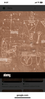
I just happened to watch a show tonight that showed the Fremont petroglyphs in Utah… and I think they may share an interesting coincidence.

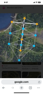
There appears to be an ancient carving in Utah that resembles the TOL & Nolan’s Cross.

Related? You decide…
 

Attachments

  • IMG_6786.png
    IMG_6786.png
    714 KB · Views: 23
  • IMG_6787.png
    IMG_6787.png
    824.7 KB · Views: 25
Except that Nolan’s cross was assembled very recently.

Nolan was trying to tap into the scam tourist attraction Dan Blankenship started by building his own attraction.
 

Except that Nolan’s cross was assembled very recently.

Nolan was trying to tap into the scam tourist attraction Dan Blankenship started by building his own attraction.
Compared to the age of the petroglyphs, America "was assembled very recently", and your comment has no relevance to the point that the two locations share a similarity w/ respect to the TOL reference.
 

Except that Nolan’s cross was assembled very recently.

Nolan was trying to tap into the scam tourist attraction Dan Blankenship started by building his own attraction.
It was first suggested in the early 1980s. The suggestion that Nolan "assembled it" does not hold a lot of water since he wasted a lot of time exploring what it could mean (no reason it needs to mean anything). This was confirmed by Robert S. Young who owned lot 5 and knew Nolan well. In his opinion Nolan was actively trying to account for it and to find relationships to other known surveyed features. Significant effort was made to clear trees and survey further along the "stem" in both directions. This suggests that Nolan was "sold" on that being there prior to his noticing of it. He didn't fool himself. The real question is "does it represent anything of special significance?" There does appear to be a clear relationship between the base of the stem of the "cross" and the road which divided the island in 1762. This would suggest that, in the case it was actually a surveyed feature, it's from 1762 at the earliest. The reported distances are a sort of suggestion that implies a plan too. If it was "faked" then there should be a rationale for why the distances compute to regular ratios. That doesn't come out of random invention.
 

What's this I've read about there being an iron stove under one of the stones?
It's a detail like so many others that cannot be substantiated. If is in fact the case then you have enough to know that a large stone was moved to a location after cast stoves became common things (1850s). That would allow you to possibly suggest that any planning in that cross layout was from the searcher era. It's one of the possibilities. If there is a noticeable relationship in the stone positions then you have to assign that arrangement to someone. It would also mean that Nolan was dumb, because he could have deduced the same thing and stopped looking. What was also said is that there was garbage all around one of those stones, and that Nolan moved some of those stones (some have alleged he moved them to conceal their exact position). The Laginas will tell you there is "cement" there that that would coincide with colonial settler sites on that island. If that's the case then ca 1760 makes sense for the placement of the stones. The question still remains as to why anyone would do that. except to mark off regular boundaries.
 

No, Nolan's Cross is total BS. He didn't assemble it but did move a rock or two to make the suggestion it exists fit better.

Yes, Nolan was sanctioned by the association of professional surveyors after he was found to have moved boundary markers in a land dispute there he was having.

The only available photos of 'Cone C' (in the tidal zone) are taken from one particular angle only.

The reason being it's not a cone at all, it's just some random rock in the water like others there.

Here is the picture of it taken to show what its real shape is.

That doesn't stop people claiming it is all some special proportional relationship so there MUST be meaning to be found there.

And also changing a few of the original measurements as they did on 'The Curse of Oak Island' to make it all fit better.

Find some rocks there, there are plenty, and you too can join them in some diagram to show they form a star, or the shape of some ancient symbol you chose or they project a line across the globe to somewhere you want to say has meaning or how the distance between two rocks is 1/71500000 the distance to Cleopatra's Needle. It all depends on which of the numerous rocks you pick and what you want to suggest their meaning is.

But of course all that is produced subjective suggestions only, none of it then exists objectively.

It's not about what is real there, it's about what they want you to waste your time on arguing how it is real because it was on TV and in colour.
 

Attachments

  • IMG_20230329_144818_749.png
    IMG_20230329_144818_749.png
    790.4 KB · Views: 16
  • nolan's fake.png
    nolan's fake.png
    96.3 KB · Views: 16
Last edited:
The picture from above of the cone rock looks interesting. It suggests that originally it really was cone shaped, but sea action wore away the base. Possibly someone with experience could estimate how long that took?
 

No, Nolan's Cross is total BS. He didn't assemble it but did move a rock or two to make the suggestion it exists fit better.

Yes, Nolan was sanctioned by the association of professional surveyors after he was found to have moved boundary markers in a land dispute there he was having.

The only available photos of 'Cone C' (in the tidal zone) are taken from one particular angle only.

The reason being it's not a cone at all, it's just some random rock in the water like others there.

Here is the picture of it taken to show what its real shape is.

That doesn't stop people claiming it is all some special proportional relationship so there MUST be meaning to be found there.

And also changing a few of the original measurements as they did on 'The Curse of Oak Island' to make it all fit better.

Find some rocks there, there are plenty, and you too can join them in some diagram to show they form a star, or the shape of some ancient symbol you chose or they project a line across the globe to somewhere you want to say has meaning or how the distance between two rocks is 1/71500000 the distance to Cleopatra's Needle. It all depends on which of the numerous rocks you pick and what you want to suggest their meaning is.

But of course all that is produced subjective suggestions only, none of it then exists objectively.

It's not about what is real there, it's about what they want you to waste your time on arguing how it is real because it was on TV and in colour.
That's not very well thought out. All we have are printed numerical details from an account from the early 1980s that do have a non randomness to them. How does one deduce a fraud from that? If Nolan picked out those measurement then he either had no bias or he had one. If he had no bias then the positions given have no reason to equate/relate to anything. The reality here is that Nolan would have needed to be informed by something he's fishing from to give us the positions he gave us. That's the starting point. If he's guilty of a design, then what is his bias for giving that? What is he trying to suggest to people which is going to be recognizable to us? It's certainly not a tree of life because that's not a feature of the points in question when treated geometrically. That's crackpot theorist stuff from after Nolan. We can compare the positions to such a regular scheme and see that they don't compute. It does look like something else, though. It's pretty obvious to me that Nolan was actually puzzled by the stones on the stem (due to their uniqueness among many other smaller erratic's and the fact they are in an alignment to a statistically significant degree). Having surveyed the heading of the stem he must have immediately noticed that it stuck out as not being random (very near 30 NE). That's not nothing. It should have worked to get him interested. Keep in mind that all other efforts he made to map stones and to relate them never gave anything else. He actually tried, and failed, to produce anything else.

The massive arm end stones were obviously never moved. They are permanent and uniquely prominent features. The one in the intertidal zone is by its nature an excellent marker/beacon for anyone approaching by water on that side. It would also have worked very well as starting reference point for the surveying of the island in 1762 as a coastal reference marker (before any tree line as ever cut). It was already known by Nolan that a marked stone had been found on the shore near it in this cove (the blown up H+O stone).

We have statistics and observation as our friends to reason this out a bit. If we are to deduce that Nolan duped himself into seeing something here then that is going to be something that we can at least quantity by looking at how convincing the suggestion was/is. If he outright crafted this detail then there has to be a recognizable influence in some story which we should look for. That's how I see it.

To think that there is nothing at OI is fine, but that doesn't align with some realities. The island was once proficiently surveyed. Alignments are features of surveys. Alignment headings tend to be chosen for a reason. If Nolan found something that makes sense to have been produced in conjunction with the survey of 1762 then that is bad news for all the treasure theorists. It also means that he isn't deluded or a fraudster. I would not bet money on Nolan having "created" this from his own cherry picking. The proof seems to be that he wasted an awful lot of time and energy to "decode" it. Delusion is another matter. There probably was enough there to convince him of something that is not warranted.

A nuanced view is that there could very well be discovered alignments on that island. The road that cut the island in two is based on an alignment, and so are the lot boundaries. The road has a certain heading. The boundaries do to. What does NC look like in relation to those? Can there be a meaning in the choice of an alignment?
 

But if the cross is a part of a standard survey practice there should be other examples of it.
What is standard can be found from reading Vitruvius, because he was still the main influence on design, architecture and planning in the early Georgian period (he's the influence on proportion that Leonardo used in his Vitruvian man in the Renaissance). The planning that Morris did in NS at various Townships shows the use of basic 2:1, 3:1 and 3:2 proportions. From that, all of geometry can be coaxed out, so nothing regular is out of place. There are crosses everywhere the road meets the lot boundaries. They just don't get presented as that, because they don't stick out as being anything but 90 degree angles.

The NC alignment's heading is not arbitrary. It doesn't randomly land on 30NE and 50NE of the road heading by chance. Neither does the appearance of the 40 degree angle that is internal to NC. Someone made that happen. It could be anyone between 1762 and 1980, but it may help us to know that another feature related to it geometrically (the Welling pointer) is from at least the 1890s. I'm not against the idea that it was imagined by some surveyor as a feature of some symbolic plan. A feature of a plan need not have any involvement in the signaling of anything treasure related below the surface, though.

It is only because we know of the Cygnus mythologies that are found in Freemasonry that we can surmise that this is what was working as an inspiration for a plan of the island that shows some Geo-metry and Astro-metry references (doesn't have to be a faithful 1:1 mapping of anything either). Pointing North is a symbolic act too. That idea is not as wild a suggestion as it appears. It is as mundane a suggestion as saying that churches were built facing East for symbolic reasons or that Jerusalem was to be seen as a spiritual pole for this globe (akin to a North star). I think we can eliminate Nolan from the role of planner here, because I don't think he was motivated by anything that he didn't appreciate. He saw that alignment as evidence of British military surveying (we know that was his view). He most likely got the right man associated with it in Charles Morris (he charted Mahone Bay for the Royal Navy in 1751), but I don't think he really understood why Morris would have preferred the heading he did for the road and it's perpendicular lot boundaries when he surveyed in 1762. The Archibalds of Truro are a different story. When they showed up later they may have had an inkling of the symbolism and THEY may have used it to adorn all the accounts we have that are unreliable. So, we would then inherit what looks like evidence of the Masonic mythologies.

By making stories align they could have benefited form the interest that this would have created for those investors who could be sold on the Christian mythologies. If you want to delve into what was in Charles Morris head at the time, you'll have to read about his personal relationship to Erasmus James Philipps, the man who brought Freemasonry to NS in 1742 to the regiment that Morris belonged to. He left a deep symbolic mark on NS. Philipps died suddenly in 1760, and his death is a possible inspiration for Morris evoking some of the details of the stories Philipps introduced him to. He could have done so by orienting the plan in a preferential direction. It may be why the NC heading is the great circle heading from OI to Jerusalem. That smells like a symbolic detail to me. It's not random. Could Nolan have understood this to fake it? You be the judge. He lived his life a the time in such a way that he tried to make sense of it. I don't think he was faking activity to make his bogus suggestion look real, but we really do not know with eccentric people. They can be quite analytical in their delusions. All this to say that there is also another way to account for it being there. That other way happens to be be echoed in the searcher era accounts of details of the alleged pit. As I have motioned before, The NS author Thomas Haliburton was suggesting that as early as 1847, so let's be clear that the Masonic linkages are there in the skepticism of the mid 19th century. Halliburton knew the people involved, and I think he recognized the stories being borrowed from to suck the public interest.

What is perhaps most complicated in all this is the many twists and turns the OI story has taken since the first accounts generated a total of zero results. The older mythologies were then put aside and things slowly shifted to pirates, and eventually where we are today. There are still today variations on a theme of a relation to stars in this story. Creative license to go a million different ways with that is being seen. But what if the story was only really about the North star and its equivalent on the globe? It's too weak a suggestion to apparently sell books. lol
 

Top Member Reactions

Users who are viewing this thread

Back
Top