Towfish vs. Downrigger

Novak5001 - yes, drilled holes and mounted with stainless bolts and lock washers. We have been tying it off the port stern corner and trailing it on about 30 feet of line which has given it a depth of 6 feet at 4.5 kts. That is subject to change, dependent on what boat we are using it behind, speed, etc. This WILL give you a layback error to compensate for. The distance of the offset between your GPS antenna and the location of the fish is going to introduce some variation between the real world and your map.

Thanks for the heads up. I figured there would be some layback involved.
 

Seeker — I think I will run that pattern. What width in between passes do you recommend?

the width will be a function of the depth, to where you can make a turn without going over speed on the sensor.

You can also use a downrigger, and attach the fish to that, you have far better control, depth and location information that way. This setup will take the strain off of the data cable, and take a hit first on the bottom debris. Already available in fishing supply shops.

Good luck

similar

BasicDwnrgr_min.jpg
 

Last edited:
on my Humminbird 998hdSI and the Solix 15SI, the width of your path can be set on automatic or manually set to some width. HUMMINBIRD suggests to go no more than three times the depth for a good side image. In 40 feet of water with the ducer 5 ft down, I run 105' out on each side. If you are just sidescanning, I'd run 150' lanes to get some good overlapping coverage, then put it in my map generation software
 

Ultimately, I am going to use ArcMap to do my final analysis. But I need to have another piece of software to bridge between the Lowrance and ArcMap.

I am debating between Reefmaster and SonarTRX. Sonar is more in my budget, but Reefmaster has some neat bells and whistles.
 

I just set up a Humminbird Solix 15 hd SI CHIRP unit for bottom mapping in shallow saltwater <less than 300'>. I would strongly disagree with the idea that you need to run that close to the bottom with a modern sonar unit to map submerged buildings.
My system uses a Z-Wing downrigger with the Humminbird transducer. We ran about 15 miles of lines with the unit today and got great images. On a flat sand bottom in 45' we were showing every ripple in the sandy bottom and on the limestone ledges every known artifact we scanned (cannons) were easily visible. Granted, cannons on the Treasure Coast are ofter partially or completely buried in sand, but you could tell it was man-made and a target worth diving on.
The biggest reason I rigged mine this way was to get away from having the boat's motion/surface action directly affect the transducer. I will probably at some point rig a surge compensation device, but first I'll have to figure out how. :icon_scratch:
If it were me, I'd try the Z-wing (less than $100) and put it down 8 or 10 feet. We survey at about 4.5 kts and this really gave us good images.
Trial and error will be your friend!
Good luck!

That is a really good idea, can you tell me the depth you are getting with your downrigger with 60ft of cable on it at 4.5 knots? Do you have any examples of images you could let me see?
Thanks

Nick
 

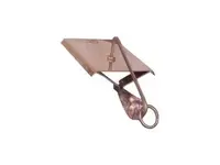
How about the trusty old drone planer...about $20.
 

Attachments

  • droneplaner4.jpg
    droneplaner4.jpg
    5.1 KB · Views: 95
That is a really good idea, can you tell me the depth you are getting with your downrigger with 60ft of cable on it at 4.5 knots? Do you have any examples of images you could let me see?
Thanks

Nick
I just wrote a 30 minute dissertation on this and lost it to screen freeze, but...
I am not convinced that the towfish idea is worthwhile unless you a) change boats often like I do or b) need to get images from more than 150'.
at a 30° angle to the surface you will get about 30' of depth
at a 45° angle - 40'
at a 60° angle -50'

Remembering that as shown in the drawing below, as the angle increases,. so will the drag force on the planer and the tension on the cable. Speed increases cause a big gain in drag as well.
Mine has a good black zip tie every 6 inches holding a piece of half inch yellow poly rope to it that is 25 feet longer than the cable, just in case something bad happens
angles.jpg

I will get the cards off the boat tomorrow and see about getting a screenshot for you.
All the best of luck
 

Top Member Reactions

Users who are viewing this thread

Back
Top