ancientones
Full Member
- #41
Thread Owner
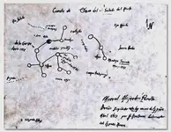
For those looking for mines in here, my guesstimate on how this would line up.This is where LaBarge turns and heads NW. I will show my estimation on his sketch map and his directions but
I have not verified this in the field. This is based off of GE and what I see.
There is a trail going straight N from LaBarge, and goes up a ridge. There is another trail to the left of this trail, a
rock pillar at this junction. There is a saddle on this long ridge, and at the end of the ridge 4 Peaks line up(N) and Weavers is South. Around the saddle area the trail goes down to enter the canyon to continue to the camp.
There are 'Mexican sign' on the hillside and a trail, this would match the sketch map if arrow is Peters. So mines on the 'West' side of Peters as well. I believe the straight and squiggly line and dot with arrow are pointing to the 'side' canyon East and its layout and mine-one of a few in this side canyon.
If his clue was 'It lies within a 5 mi circle of WN, Volcanic Peak, rock sticking up', his other clues will fit.
There is a 'large gold deposit' that runs 3 mi. along a ridge 'pushed up' exposing this on the Western
edges. The people finding and mining them(1846, 1847) had to leave, but they made sign/maps so future trips would know where to go-these were not 'tapped out'-they have value to come back to.
Is this the LDM? Which one?
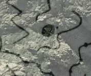
View attachment 2073688
View attachment 2073689
Thank you skyhawk1251 for the mine your found on the mtn.


