skyhawk1251
Sr. Member
... The woman's name was Maria Rables, and she was a widow. We found her living in the mining camp of Big Bug, near Humboldt, where she was taking in boarders. She was an intelligent woman, and she talked freely. Her story proved interesting indeed. She told us that, as a girl of fourteen, she had ridden a mule from Sonora to a gold mine in the Superstition Mountains of Arizona in the company of her sweetheart, Juan Gonzales ...
Maria said that Gonzales and his partners brought gold up from a pozo (shaft), working in their bare feet and climbing short ladders, which stood on terraces. They carried the ore in sacks slung over their backs and supported by straps around their foreheads. The material thus brought up was passed through a sieve, and Maria told us that she would amuse herself by taking some of it in her hand and blowing the waste away and then holding the gold in her palm. The gold was in small particles, like wheat grains ...
I asked her to tell Jim and me about the region in which she saw the mine. She said that they had gone up a trail by a peak, which we recognized from her description as the tortuous horseback trail by Minor's Needle from Bark Valley. As to the direction they followed from the summit, Maria said that they went down over a falda (slope). She repeated the word many times. This meant that they went north as far as Le Barge Canyon.
"What did you see there?" I asked. And Maria answered that in the background, a few miles away, there were three peaks, the middle one being the farthest away.
Jim and I recognized these peaks -- they mark the summit of a long arm extending northwest from Tortilla Mountain, which has an altitude of five thousand feet. Indeed, so vivid were Maria's memories of the terrain, so candid her answers, that we had no doubt that she, too, had seen and held in her hand the gold of the Lost Dutchman. -- "The Lost Dutchman Mine" (Chapter 13) by Sims Ely.
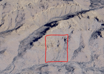
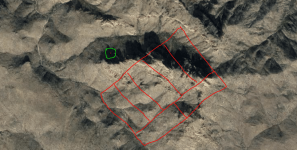
Could this be the pit described by Maria Rables, now mostly back-filled? The pit's location is indicated in the images below by placemarks. Were the three peaks she saw on the ridgeline extending northwest from Tortilla Mountain, as Sims Ely wrote in his book? Was the pit seen by Maria Rables not the Lost Dutchman mine, but a paleoplacer deposit? Did Alva Reser and Roy Bradford, who prospected this site, fail to find anything, because they didn't dig deep enough?