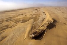
The Pearl Ship

Hey guys,
Just wanted to let you all know that I just got back from LA main Library and I did find a couple listing in the El Centro area for a " Jacobson " From 1907-1924. By 1924 there was only 1 left and in all that time there was only 2 listed as ranchers. I should have a better answer as far as where their land was by next week-I hope-. In the directory it simply says the name, followed by rancher, and then x number of miles from town. I'm going to try to get to El Centro next week and see if they can put a property to it.

PLL
 

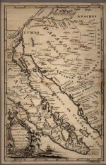
Meanwhile take a look at this map from the " Kino " years and note how far north the gulg goes. If the ships from Itrube, Mendoza or even Cavendish were at the most a 100 years earlier then possibly they gulf may have connected to old lake Cahuilla. It's just a little info.
PLL
 

Attachments

  • kino map.jpg
    kino map.jpg
    44 KB · Views: 1,718
Hey Mike,
This might put Mendoza's mutiny boat somewhere on dry land ?? Just a thought. I know the maps of this time are not the most accurate. However I think this based on actual exploration as opposed to guessing.
Pll
 

On finding which Jacobson's ranch. One of Choral Pepper's books had a mention about how much money he had when he left imperial valley. she found out that info through a newspaper account or tax record or something like that.
 

The newspaper account is from the Herald Examiner ( now defunct ) in 1919. I was in the main library in LA last week and got copies of the " j's " from the city directories from 1907-1924. In 1907 it list only one Jacobson ( not JacobsEn ). There is no first name it simply says " rancher " and the address is only a note of direction and distant from town. The town also was NOT El Centro but Imperial. A couple of years later the rancher has a first name and a different mileage from town. In 1917 it gives direction and includes a second name at the same address. I assume that would be his wife. In 1924 he's gone. I am going to Imperial tomorrow and seeing if there is anything in the city archives. Stay tuned.....

PLL
 

Yeah I think I was at that bar. Actually right now I am enjoying a GREAT burger at the Red Ocotillo and using the laptop. I just spent the day in El Centro and was able to find a lot on the subject. I found ALL of Jacobson's properties and even got a picture of the old boy. I went to the Pioneer Museum and got a TON of help from them. Not only did I find where the ship should be but I also found a newspaper article of a interview with a man that worked on the ranch as a young boy and talks about where the ship was. According to the article Mrs. Jacobson showed him some of the " loot " a ruby to be exact. My battery is running low so I will continue this tomorrow.... Sweet Dreams.
PLL
 

Ok all,
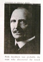
Here's what I found out so far, Nels ( short for Nelson ) Jacobson did own 720 acres of land in Imperial and when he left he sold it and 1000 hogs for about $ 137K. He did sell gems in LA. He cut a deal with a pawnbroker named Barney and a lawyer. All of them split the money 3 ways so as no law would be involved. Here's a foto of Nels.
PLL
 

Attachments

  • Picture 028.jpg
    Picture 028.jpg
    22.9 KB · Views: 1,266
I found something that gives a clue to the approximate location. Within 80 acres or so and I am sure it is buried DEEP. Of course there is more but I just can't say for now I want to verify a couple things first and then I'll let everyone know.
PLL
Mike check your mail...
 

Hi all,
I was looking thru some old things and I found a newspaper article that states that someone thought the wreck came from 1618. The 2 I was looking into was someone from the Mendoza fleet ( like Gollum ). The other was a English Capt by the name Cavendish, however he was from around 1586. Does anyone have anything from 1618 ?? I would be interested to see who it might be..
Thankx All
PLL
 

1618 could Still be either one of Juan De Iturbe's boats or a dutch pirate.
Iturbe did report that pirates captured one of his boats on a voyage sometime after the better known incident of 1615. Iturbe was Pearl fishing in the gulf from 1615 until retiring sometime after 1632.
 

Most of that area is incorporated into the San Sebastian Marsh Wilderness Area.

Much of both sides of Old Kane Springs Rd. are only accessible by foot or horseback.

:'( :'( :'( :'( :'( :'( :'( :'( :'( :'( :'( :'( :'(


Best-Mike
 

Thought you guys might like this from Redlands University.
The Salton Sea was NOT an accident.

Within historical times, water has been present in the Salton Basin more often then not. As sediment was eroded from the Grand Canyon, it would flow down the Colorado River into the Gulf of California. This sediment would deposit itself along the river bottom to a point where the river would change its course and flow into the basin, following the path of least resistance. It is estimated that the basin would take 18 years to fill to the point of overflow, forming the Ancient Lake Cahuilla, at which point the Colorado River would then flow to the gulf again. With no new inflow, Lake Cahuilla would take approximately 60 years to dry up. Radiocarbon dates from marsh deposits and archaeological sites around the lake indicate from three to four major infillings over the last 1300 years, each lasting for up to several hundred years. Recent finds also indicate much earlier phases extending well over 2,000 years ago. The chronology of Lake Cahuillas most recent phases continues to be refined with new archaeological investigations. Current data, including 85 radiocarbon dates, indicate a complete filling in the 13th century A.D., a recession in the late 14th or early 15th century, another infilling in the 15th century, a recession in the late 15th or early 16th century, and a final filling in the 17th century followed by the last recession that ended soon after A.D. 1700. There were also partial infillings and many fluctuations in lake levels over time. (Jerry Schaefer Ph.D., ASM Affiliates, Inc.) At the time of the formation of the Salton Sea, evidence indicates that the river bottom was choked with sediment and the river was preparing to swing north into the basin once again. The accident that caused the was in fact an attempt by the California Development Company to dig a new diversion canal after repeated complaints from the farmers of insufficient water in their sediment clogged irrigation ditches. As it would happen, 1905-1906 were years of heavy rainfall and snow pack which in turn caused large spring and summer flooding. The river would probably have turned into the basin regardless of any canal construction. The Salton Sea (Lake Cahuilla) was not an accident then and it is not an accident now. It is a vital resource to migrating birds whose wetland habitats have now been reduced by over 90%.

Might help and place a timeline.
Pll
 

Hey all,
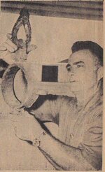
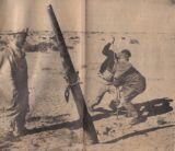
While i was down in Imperial County i found a newspaper article from the late 60's about some guys who found a ship south of the border. Here are the pixs from the article. Gollum I think Geo M. knew these guys and knew where this ship was. The paper said the the "collar" around the mast ( see lostship4 ) was hand forged and handmade. let me know what you all think of this...

PLL
 

Attachments

  • lostship4.jpg
    lostship4.jpg
    67.8 KB · Views: 1,252
  • lostship5.jpg
    lostship5.jpg
    5.4 KB · Views: 2,301
hey did anyone see the trailer for King of California with Michael Douglas ?? It's about a treasure hunter and a ship I think ??

PLL
 

Hello all,
Lately I have been trying to connect some of the dots in my theory. One of them was the story of a young guide who was with De Anza and found the " pearl " ship. Most of know the story but for those who don't. Basically he ent to the " right " of the path De Anza was taking. If this is true there should be a passage in De Anza's diary. There is. But also he talks of finding " sea " fish in small pools. He was quick to say that they were not lake or stream fish. To me this says that the lake would have just recently dried up. here's the passage I found:

Saturday, March 5.–Starting shortly before daybreak, we went west-northwest for about six leagues, having on our left a medium-sized range, [Footnote 96] toward which we traveled three more leagues to the northwest. Then we went between some medium-sized hills which make a good pass, after which one turns to the west to go around some sand dunes near them. In this direction one travels a little less than two leagues, during which the sand dune is doubled. After this one turns again to the north-northwest for about a league and a half, coming to some wells of fair surface water, and some pasturage. We reached the edge of the wells about vespers, and I named them San Eusebio. [Footnote 97] The journey made to this place in the manner described did not turn out so favorable to us as we had flattered ourselves it would, because of the prevarication of the guide.

On doubling the sand dune mentioned one comes out to an estuary of the sea. At least we inferred that it must be an estuary, because we found stranded an nfinite number of fish of kind and size appropriate to the sea and not to lakes and rivers, however large they may be. Whether or not this lake is of live water I am not able to say with certainty, but I do know that it is water depending upon the Gulf, from which it must be distant about thirty leagues, if not more. This estuary is the one which appeared to Father Garcés two years ago to be the Rio Amarillo which he mentions or cites in his diaries, because it did not occur to him to test what it really was, for he did not taste the water.

Within a few hours during the night such good water as flowed from the wells was completely exhausted, the new which came in being so salty that not even the animals could drink it, although more than half of them, which had not yet been watered, were greatly in need of it. All this trouble and care was added to the hard journey which we had made today.–From Tubac to San Eusebio, 188 leagues.

And this is the one about the guide leaving:

Sunday March 6.–To add to our ills, in the morning we learned that our guide had fled, leaving us his poor weapons as signs at the place where he had slept. For this reason, and for the lack of water which we were suffering, I sent six men with a corporal to look for the watering place which our runaway guide had said was nearby. The corporal bore appropriate instructions in case he should find heathen there or in any other place and to report to me whether or not he had found the water.

According to the story the guide was riding to the right looking for any alternate path. Plus he was traveling at night due to the heat. This ties in the connection with Imperial county. He found the ship half buried in a sand dune and took " as many pearls as I could carry ". Then headed straight for San Luis Rey Mission. Sometime later tried to find the ship again but never could. Think about it, you are trying to find a " sandhill " in the middle of a wasteland. The old needle in the haystack routine...
By my approxiamation I would put De Anza somewhere W of the Superstition Mts. I am righting this to see if the calculation is correct or would he have been further north. Any ideas???

Let me know if you can
Thankx to All
PLL
 

Ah this old legend refuses to die, and with good reasons. As for the possibility of even more lost ships here is one I have tried to track down personally:

A frequent theme in the sightings is that of a Viking ship. Around 1930, Julian residents Louis and Myrtle Botts, camping at Agua Caliente, were joined by a lone prospector asking to share their fire for the night. The couple was entertained by the man’s tales of his quest for precious minerals in the area, and soon the fortune seeker produced some dog-eared photographs. The images were of a ”wreck of a ship of some kind” that he had stumbled upon while prospecting down near the Mexican border. Though the photographs were quite worn, Myrtle Botts was surprised to see that the “ship,” half-buried in the bank of a wash, appeared to be of Viking design, a long boat, complete with a carved serpent on the bow. In the morning the prospector had moved on, taking the exact location of his “lost ship” with him. 2 Desert writer Choral Pepper writes in her Mysterious West that the Botts actually located the wreck first hand from the prospector’s directions, only to find upon a return trip that the ship had been buried in a rockfall as a result of the destructive Long Beach earthquake of 1933.

Photos of this wreck did exist, but do they still exist? I had zero luck in tracking any photo or even a reprint, but if anyone else has I would sure appreciate having a peek.

Good luck and good hunting, I hope you all find the treasures that you seek.

Oroblanco
 

Hey Oro,
I found thid pix.... Was this the one ?? just kidding....
PLL
 

Attachments

  • lost ship4.jpg
    lost ship4.jpg
    61.7 KB · Views: 22,774

Top Member Reactions

Users who are viewing this thread

Back
Top