EagleDown
Bronze Member
- Joined
- May 13, 2010
- Messages
- 1,857
- Reaction score
- 629
- Golden Thread
- 0
- Location
- California
- Detector(s) used
- Whites MXT, Whites TDI
- Primary Interest:
- All Treasure Hunting
- #21
Thread Owner
Re: The Many Lost Treasures of Mariposa, CA
Hokay, it had been suggested that I try the dredging up river, just below Briceburg. So, here I am in Mariposa. I've finished getting gas, Pepsi's and ice at the Mohawk Beacon station on the North end of town. (Around 1980, the name was changed to BP.)
I pull out on to hiway 140 and head North, towards Yosemite Nat. Park.
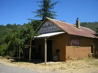
Beautiful country! The first interesting place I spot is an old cedar(?) building at the junction of Triangle Rd. I couldn't help but wonder how old it was. I had done a little reading about Mariposa and had found that the court house was/is the oldest courthouse in CA, that is still in use as a courthouse. Since 1852! And, at that time, (and 125 years later,) the old belfrey clock still kept good time and the bell still rang the hour and half hour.
Another little piece of info. was that Mariposa County was at one time, the largest county in CA, taking up parts of LA county and a good portion of San Bernardino county. If I remember correctly, it was split up into 12 other counties. If you would like to see the old courthouse, I took the link from Wikipedia: http://en.wikipedia.org/wiki/Mariposa_County,_California
Oops, better keep my mind on the road. Hiway 140 wasn't exactly a "Interstate Hiway" back in 1961. (Come to think of it, it still isn't.)
The next point of interest was Mid-Pines with it's combination store and post office + 2 gas pumps, where in later years, the owner allowed me to go under the wooden front porch with my metal detector, where I picked up so many coins off of the surface, (mostly silver,) that I never did use my metal detector. I always intended to go back with my MD, but never seemed to have the time. (You might keep that in mind if you're ever passing through Mid-Pines.) I could also show you an old dump about a half mile off of the hiway, (by a paved road,) where I found old auto license plates dating back into the 30s. They were barely covered by a layer of pine needles. I left them there. I have never been a collector of artifacts, unless they are made out of gold. (Sorry, I know where the road is, but I don't remember the name of it.)
Another mile up the hiway, on the left, is the old Muir Lodge, and just beyond that is a small bridge, (you'll have to look quick, or you'll miss it.) Just after passing over the little bridge, (Bear Creek,) there is a "turn out" where you can park before starting down the hill to Briceburg. I stopped here once in the early 80s and just for the heck of it, made about a 5 minute search with my Garrett ADS2. I picked up a 1945 Mercury dime in AU condition, under the old cedar tree, (which is still there.) You see, my interest was purely acidemic as I knew there was once a small market there. I guess they tore it down after the mines shut down in the 1920s.
While you're looking around, look directly across Bear Creek and up the side of the hill. You should notice signs of mining there. What you're looking at is the site of the King Solomon Mine. The Colorado Book of Mining and Geology lists it as the richest mine in CA while it was in operation. I believe the Mariposa Mining Museum has some specimens on display. I've held fist sized chunks of quartz, (a friends) that 2/3 of the weight was gold. Makes my hands itch just remembering it.
OK, we've wasted enough time here, let's get on down the hill to Briceburg.
Tomorrow.
Hokay, it had been suggested that I try the dredging up river, just below Briceburg. So, here I am in Mariposa. I've finished getting gas, Pepsi's and ice at the Mohawk Beacon station on the North end of town. (Around 1980, the name was changed to BP.)
I pull out on to hiway 140 and head North, towards Yosemite Nat. Park.
Beautiful country! The first interesting place I spot is an old cedar(?) building at the junction of Triangle Rd. I couldn't help but wonder how old it was. I had done a little reading about Mariposa and had found that the court house was/is the oldest courthouse in CA, that is still in use as a courthouse. Since 1852! And, at that time, (and 125 years later,) the old belfrey clock still kept good time and the bell still rang the hour and half hour.
Another little piece of info. was that Mariposa County was at one time, the largest county in CA, taking up parts of LA county and a good portion of San Bernardino county. If I remember correctly, it was split up into 12 other counties. If you would like to see the old courthouse, I took the link from Wikipedia: http://en.wikipedia.org/wiki/Mariposa_County,_California
Oops, better keep my mind on the road. Hiway 140 wasn't exactly a "Interstate Hiway" back in 1961. (Come to think of it, it still isn't.)

The next point of interest was Mid-Pines with it's combination store and post office + 2 gas pumps, where in later years, the owner allowed me to go under the wooden front porch with my metal detector, where I picked up so many coins off of the surface, (mostly silver,) that I never did use my metal detector. I always intended to go back with my MD, but never seemed to have the time. (You might keep that in mind if you're ever passing through Mid-Pines.) I could also show you an old dump about a half mile off of the hiway, (by a paved road,) where I found old auto license plates dating back into the 30s. They were barely covered by a layer of pine needles. I left them there. I have never been a collector of artifacts, unless they are made out of gold.
 (Sorry, I know where the road is, but I don't remember the name of it.)
Another mile up the hiway, on the left, is the old Muir Lodge, and just beyond that is a small bridge, (you'll have to look quick, or you'll miss it.) Just after passing over the little bridge, (Bear Creek,) there is a "turn out" where you can park before starting down the hill to Briceburg. I stopped here once in the early 80s and just for the heck of it, made about a 5 minute search with my Garrett ADS2. I picked up a 1945 Mercury dime in AU condition, under the old cedar tree, (which is still there.) You see, my interest was purely acidemic as I knew there was once a small market there. I guess they tore it down after the mines shut down in the 1920s.
While you're looking around, look directly across Bear Creek and up the side of the hill. You should notice signs of mining there. What you're looking at is the site of the King Solomon Mine. The Colorado Book of Mining and Geology lists it as the richest mine in CA while it was in operation. I believe the Mariposa Mining Museum has some specimens on display. I've held fist sized chunks of quartz, (a friends) that 2/3 of the weight was gold. Makes my hands itch just remembering it.

OK, we've wasted enough time here, let's get on down the hill to Briceburg.
Tomorrow.

Last edited:


 Keep it coming!
