Swift and the Waybill

Thanks guys. I was solo at that time but always had a partner after that. Wish I had a video of how I got out of there it would show you how a person can get in areal predicament. It was evening and no one knew where I was...silly but it happens...I live over 2 hours from the area so its not like your family can just go look for you. No more climbing and repelling without someone there.
 

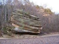
In the world of maybe...here is a picture of a rock that if you have a big imagination may look like a buffalo sitting on a hillside, it is very close, actually in the middle of the 6 silver mine locations. So again Swift mentions a buffalo rock, the Indian mentions this rock in his descriptions of the Waybill landmarks. Buffalo rock maybe.JPG
 

A few posts back I put up a picture of some turkey tracks, they were close to a waterfall, and there was this rock among even larger ones that have a silvery looking material...I should go back and get a sample and have it analyzed... unless someone knows what it is already. doubting its silver.hard silvery minersl near TT.JPG
 

It actually looks like it is sprayed on? It could be silver if in it's natural stage.
 

In the world of maybe...here is a picture of a rock that if you have a big imagination may look like a buffalo sitting on a hillside, it is very close, actually in the middle of the 6 silver mine locations. So again Swift mentions a buffalo rock, the Indian mentions this rock in his descriptions of the Waybill landmarks. View attachment 1571549

Sorry, but I don't see it at all in the foreground rock, maybe on the rock in the background?
 

A few posts back I put up a picture of some turkey tracks, they were close to a waterfall, and there was this rock among even larger ones that have a silvery looking material...I should go back and get a sample and have it analyzed... unless someone knows what it is already. doubting its silver.View attachment 1571551

Yea, from what I have been told...silver only looks silvery when in its more purer (refined) form. In its natural state (ore) It should be a dark blue to black in color. This almost looks wet...I have no idea if mica looks like this or not? Specs of white looks similar to what I have been told is Rockcastle conglomarent (spell check), its a type of sedimentary rock.
 

Last edited:
The big rock in the foreground, the hump in the middle and the lower left maybe the head? On one of my early trips time out there a snow storm came up on us relay fast and we took refuge behind that rock, and the storm was so intense it was scary, we could not see our hands in front of our face....literally.

On the shinny rock, don't think it was mica as it wasn't flaky, just going to have to hike down in there again. I think it maybe one of the most serine places I have been, a snow was on and the area had a lot of hemlocks and the babbling stream..wow! We found a tunnel like place that looked like it may have been to a mine, but didn't go too far as we were afraid of meeting a bobcat or angry raccoon face to face. I am working on a camera rig to use in cases like that,, using a larger RC tuck with lights and camera mounted to it.
 

rock composition

A few posts back I put up a picture of some turkey tracks, they were close to a waterfall, and there was this rock among even larger ones that have a silvery looking material...I should go back and get a sample and have it analyzed... unless someone knows what it is already. doubting its silver.View attachment 1571551

what this appears to be to me is one of the platinum metals there is several that is white palladium ,rhodium is another it would be worth while to investigate .
 

rock with white spots

for got iridium is also white it is very hard palladium and rhodium are soft and mallable
 

Huh I thought those were isotopes of platinum.... chemistry was so long ago. I should have paid more attention and also taken some geology!
 

hay I know those turkey track rocks I've ben to them many times, my wife's family just live on top of the cliff area.
I have looked in that area and found several hole that have been drilled in the rocks under the rock houses .
and about two hollows down stream on the left there is a mine with tailings at the mouth of it .
it only goes back about 30ft.
 

Well, it sounds like a hike to get some samples is in order. DSN - I may have met your mother in law, it was about 5 years ago when we were there. If so your wife comes from good people..really enjoyed talking with the folks!
 

Anyone up for a meeting to follow the Waybill? Brushy is finding some new stuff. We could meet at the boat ramp on

Caney ...maybe someone as a boat? My little john boat wont work for more than 2.
 

I would love to, but I have no boat! I'm more of a ...hiker than paddler. If you have room I'm in, or winter water levels where we could walk the stream? Either way I am interested!
 

Last edited:
I would love to, but I have no boat! I'm more of a ...hiker than paddler. If you have room I'm in, or winter water levels where we could walk the stream? Either way I am interested!

I wish I could go with you, but do not have the free time. In times past I have left the NC Line at 2:00 AM, drive to Caney Creek and back the same day. I have been up there an hour before daylight. Good ole days have come and gone.
 

The stream does get small enough in February to walk around to the Gap with a Lid on it...but even using the gap to get to the Little Sandy you have too much water to get to the other side. You can get to the line of rocks by walking from the cemetery (parking) but its too deep to cross there too. (about 15 feet by a strangers fish finder) I will try to see if MASON would bring his boat..if me, brushy, KY hiker, and another person went that would probably be all that could ride in his boat..no reason we couldn't make a couple of trips to drop more off and go back to get the rest. We just need a boat for one day to do the water traversing part, then maybe in another week or so take a day to finish the waybill on land....I always want to start at the begging for some reason. If mason was tied up we could actually walk down to the line of rocks and ferry people across there with my John boat..the problem with it is I only have a trolling motor so its really slow. Ideas?
 

I'll let you decide on logistics since I am not familiar with the area. Ferrying people across sounds like a plan, I didn't realize the waybill criss-crossed the stream. What is the total distance for the waybill walk?
 

The ferrying thing ..like you mentioned Hiker, may be the easiest, but I have to tell you that the walk down to the area where the line of rocks are...its very steep and easy to get down and very very rough coming back out. This time of year with the lake backed we would have to ferry from the north bank about 100 yards from the line of rocks as the water comes up to prevent you from walking over to the line of rocks.

If you could walk it all (and taking the Gap as a short cut) I would estimate it to be 3 to maybe 4 miles...only because of the meandering of the river and creek, as the crow flys less than 3. But its not all flat either...most of it is not bad walking....a little scampering over rocks, and about 1/8 mile is up a steep incline. The whole thing could be done in a day if a boat was used.
 

Top Member Reactions

Users who are viewing this thread

Back
Top