Stone Tablets-Most likely planted fakes.

The stone maps are correct. But they are a general view of the area, not a x marks the spot map.
 

I found a stone with a cross in it along with others, 40 years ago.
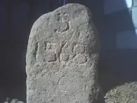
Picture of me as a teen with a stone marked 1568. I'm 56 now.
View attachment 1142221

S.S.
8
156B

It's a modern looking carving. Was it found within a large group of mining claims, or within subdivided land - possibly something in Section 8 of a surveyed Township?
 

I found a stone with a cross in it along with others, 40 years ago.
Picture of me as a teen with a stone marked 1568. I'm 56 now.
View attachment 1142221

Carrol, Welcome to Treasure Net!

Very interesting!

I found a marker similar in nature near a vey old Spanish Mine I'll see it I have a photo of it.
 

The stone tablets are very accurate , but to understand them , have to know the region where are the mines . The mines are seven in the region of the stone maps , five in the latin heart ( 3 meus , a caverna aurum and the moneta ) and two in the stone trail map ( the first two X from the bottom because the upper X in the heart , is the same with the " moneta " from the latin heart ) .
All the drawings in the maps , describe the ground's relief of the region .
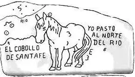
I post the larger map in reality , which is the Horse map . The picture is from GE so is not 100% real but is very close to the map .You have to use your imagination to see the horse , but I believe how is not very difficult if compare with the horse map . The horse's right ear touch the stone heart .
Enjoy it !

The Cobollo.jpg horse stone map.jpg
 

Last edited:
The stone tablets are very accurate , but to understand them , have to know the region where are the mines . The mines are seven in the region of the stone maps , five in the latin heart ( 3 meus , a caverna aurum and the moneta ) and two in the stone trail map ( the first two X from the bottom because the upper X in the heart , is the same with the " moneta " from the latin heart ) .
All the drawings in the maps , describe the ground's relief of the region .
I post the larger map in reality , which is the Horse map . The picture is from GE so is not 100% real but is very close to the map .You have to use your imagination to see the horse , but I believe how is not very difficult if compare with the horse map . The horse's right ear touch the stone heart .
Enjoy it !

View attachment 1144305 View attachment 1144310

The Horse map says you pasture north of the rio but the door symbols place the mines south of the river not north.
The cross on the hill points the way. Same cross with the Skull I show in the solar / lunar thread. My reasoning for the
horse side of the stone are the numerous carved horse heads through out the site which leads me to believe the map itself is a
Final Placement map for the end of the trail. But hold on because they used the horse at the beginning of the trails also!

So what the map accomplishes I believe is both. It's a long distance map that also works for the end. Dual purpose map!

Large horse becomes smaller and smaller as you get closer to the goal of the treasure gold mine site! Mirror Images Janus figures

Janus
'I am the beginning and I am the end'

This "Foot measured Path" it is dangerous'

'I am eighteen places'

'Follow the heart follow the map'

'I camp north of the river with my horse from Santa Fe'


Reverse it all as it has a river running through it!
 

No claims in that area that I know of back then.
heres another rock with codes.

View attachment 1144893

This marker was actually next to an area that the t-handled probe
after 2 foot would fall to the ground & I could hear rocks falling underground.

Carrol,

Nice photo!

I'm more intrigued by the mound the stone is sitting on!

That's a classic door or mine symbol!

It's all about the doorways with those masons everything's a doorway!
 

Hence the newspaper article I posted in another thread.
 

Last edited:
Bill

The horse is north of the " RIO " . The RIO is a temporary rain stream which runs from the horse's legs to his ears . The word RIO in the horse map is in the same place with the words " DESILIENS AQUA AURUM " from the Latin heart . So , the cross in the canyon shows the direction which runs the torrent .
The 18 places are biger rocks with marks . The trail is danderous because the DON trail is on a very steep side of a mountain .
The start is the end because to go to the start point of the trail , have go to from the same way which the trail ends ( only in the Don map ) . Don't exist another way to approach the start point .

Have a nice day

Marius, So your reading the Latin Heart with the Horse Priest Map?
I never thought of it that way!

My experience with the dangerous trial has been the magnificent outcrop monuments that are obviously booby trapped and dangerous once you climb them for reading.

The 18 Places I've never quite understood unless it means one of eight places which kind of makes more sense with the numeral 8's I've found at the final Gold Mines site down here.

Of course '8' is also the sign for Infinity the system they utilized for creating the monuments and markers so it could be saying;

'I am one with Infinity in these places of God' or it may be a reference to the astronomical sky.

At the site I work the ground based cross laid out on the mountain with monuments tip too tip are exactly 360 Castilian Feet. The master keys map shows the numeral "75" and behind it is a white horses head rough hewn with the letters 'FIN' carved in the outcrop behind it.

I believe the 360 represents the compass and the letters 'FIN' the final measurement of '75'.

This site has two old prospects near the monuments that look to be not very deep and possibly lost leaders for those that may make it that far with the map.

Those that may make it that far do not know about the 'Key Map' a couple thousand yards away from those shallow prospects giving the final measurements to the hidden rabbit hole entrance near by and always follow the cross which leads to a massive death trap that would bring down a quarter of a mountain on top of any would be interloper's of his Majesty's Royal Treasures.

We all have our own opinions and interpretations of the Stone Maps and it's with great pleasure I read yours as it always makes me think with an open mind about what I work that I found down here.


They did hide their entrances in small wash basin's and redirect the stream while working the underground vein of rich gold so the small torrent of a dry wash would be very plausible.

Thanks for the info!

And a good day it is!
 

Last edited:
Wyatt ( Bill )

No , I didn't read the Latin Stone map using the Horse map . The Horse I found using the mines in the Latin heart .
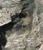
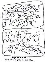
I made a picture from GE with the stone trail . Compare it with the stone trail map . I believe how is very close .


Trail.jpg Stone trail.jpg
 

Last edited:
The horsehead map shows the Rio Grande and the Caballo mtns deposits quite clearly. :laughing7::laughing7: :occasion14:

Don Jose

Yes , could be :tongue3: if we change some characteristics of the horse .
Here we have two horses in the same mountains complex . The horse from the stone map which his whole body is described up side down on a mountain side north from the latin heart , and the horse head which is described on a cliff close to the LDM ( Apache ) . This horse head we can see in Julia's map and in a DeGrazia sketch .

:coffee2::coffee2:
 

The Horse, in my opinion, can be broadcasted on mountain tops and sides in many different ways. The Horse Head, the body, a long necked three legged Giraffe type abstract used for a pointer up the side of a Mountain Trial.

It can be in shadow or rock or even sunlight direct reflection.

Take a look at this sun produced image. In the first photo you can see some sun reflected pointers but look at the second image in the right upper corner an upside down Horse complete with bridle, saddle and what looks to be ore in the bags.
This is a small image near the end of a trail. Right time of day has a lot to do with it.


View attachment 1145781View attachment 1145782

At the same site and below is a rock Horse Head with tongue sticking out slightly.

View attachment 1145786
 

Last edited:
Bill

Personally , I don't believe in the shadow signs . Most of the maps , like the stone maps , are 2D and all the markings are land shapes and land outcroping .
I have see 3D maps like Perfil and Minas del oro , and combination of 2D with 3D like in the Guzman map of Llanganati .
 

Bill

Personally , I don't believe in the shadow signs . Most of the maps , like the stone maps , are 2D and all the markings are land shapes and land outcroping .
I have see 3D maps like Perfil and Minas del oro , and combination of 2D with 3D like in the Guzman map of Llanganati .

I guess it's my job to show you guys they do exist.

I just purchased a bunch of equipment today for doing just that. Up until now surveillance type cameras couldn't zoom.
I bought a time lapsed camera 20 megapixel with lock box hand held reader, pole, extra 32 gigabit SD cards, extra mounts I'm serious about showing the existence of not only a shadow based symbolic language but a sun based language!

I've always been lucky in the shots I've taken. You know right time of year, day, angle so on.

I plan to buy at least six more cameras with time lapsed features. Not all of them have it yet for waterproof field cameras.

In order to find the right angles and distances I'm going to surround the important monuments with these camera's close and far in a circular pattern with a shot every ten minutes day and night (For Lunar illuminated images) for the whole year. They had sacred solar times and sacred viewing angles for the map system which I intend to show.

I don't believe in KGC Treasures either but like you we all have our opinions on different systems and usually don't deviate from our own work as it would be throwing out the dishwater with the dishes.

Sadly, I can't just post most of my proof so far it would be giving away years of research just to prove a small point.

So I'm going to show many different aspects of these symbols in actual time lapsed 'Metamorphosis' so anyone can see how they did it and when is the best times to view these fantastic images. The Warlock Priests had photographic memories unlike anything we've ever seen until the invention of digital camera's.

You talk about 2D and 3D just like I do. That's part of the way they viewed their own image creation.

Thanks
 

Top Member Reactions

Users who are viewing this thread

Back
Top