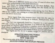
Silver Bars

I have been doing alot of research about this lost silver near Uniontown.....I live here and have been at the courthouse, library, and have been doing alot of research online. I can't find anything about this story until the 1970's. I don't think it is accurate. For one, there are really no caves "North" of Uniontown. I propose another location as the possible site for looking for this treasure and I will state some of my reasons.

The site I will be searching is near the Quebec Run Wild Area off of Quebec Road, about 14 miles from Uniontown and about 2 miles from Laurel Caverns. This area is littered with rock formations and caves. In the earliest maps of Fayette County you can find the Quebec Road, and in one map from 1816 this road is called "Turnpike Road". This is one of the earliest roads in the county and goes from Haydentown to Elliotsville, I found reference that it was either the third or fourth road cut. In the 1800's this area was full of mills and tanneries and iron furnaces. There are remnants of these still today, if you look close enough. So, 150 years ago, even though remote, it was bustling with industry and the road would have been well traveled. The second reason for my thinking that buried treasure is in this area is that people after the Civil War thought so. It is not documented on paper, but in the dirt itself. There are dozens of shallow holes hastily dug into the dirt, in the woods, in the Quebec Run Wild Area. I was up there this weekend to finally look for myself, and it is evident that long ago, people were digging holes up there. What were they looking for? Well local legend says that during the Civil War confederate raiders hid gold in a cave "above the run" and sealed the entrance with a blast. Well this is where all of the holes are dug, above the run.

So, right after the Civil War, people heard stories of either gold or silver having been buried by Confederate Soldiers and people started looking for it. I don't know if it has ever been found but it is interesting nonetheless.

Anyone have any thoughts on this? I would be willing to have a companion on these adventures, it is a long walk out there by yourself (about 1 mile).
 

In Old Economy County park is a shelter called the silver mine. Local lore said there was a silver mine back in the woods because of shallow depressions in the ground. What they are in reality are the remains of clay mines...for making brick.
The girl scouts did a nice job of restoring one of the sites back in he woods.

Al
 

I grew up just north of U'town. Me and my bmx mates scoured every trail between my house and U'town. The topography's very dynamic. Behind my house was Monarch mines and just south, towards U'town was what we called the bowl. A strange impression that we often talked about. Of course we wanted to clear it out and make a bmx trail in the early 80's. I'm looking forward to putting the kids to bed tonight and reading through this article. If something like this is to be found it will take the knowledge of someone that's lived there and has spent time in the woods. Our trail building found us lots of strange geo impressions but the area was heavily mined.
 

How do you go about starting to find out information on this? It would be an awesome adventure even if nothing is found.
 

does anyone have any more info on this....this story has really gotten my attention.

What are the names of the mountains around uniontown. Also what is the name of the companies that used to mine in those areas
 

Allegheny mountains, Chestnut ridge. However these are to the west of Uniontown. There's no "mountains" due north. I was just out there this past weekend visiting my folks and was thinking about this. Their house is due north of U'Town. My guess is, if this is true, no one hauled 15 tons of silver 3 miles up the mountains in the mid 1800's. I really don't know all the details though. I'd bet this cache is in the hilly area that surrounds the city.
 

Allegheny mountains, Chestnut ridge. However these are to the west of Uniontown. There's no "mountains" due north. I was just out there this past weekend visiting my folks and was thinking about this. Their house is due north of U'Town. My guess is, if this is true, no one hauled 15 tons of silver 3 miles up the mountains in the mid 1800's. I really don't know all the details though. I'd bet this cache is in the hilly area that surrounds the city.

I read a story which stated they where hauled away by a bunch of wagons. If the dobbs story is true i have no clue how he would move all of that by himself without someone seeing him. I doubt he really would have taken them far
 

has anyone heard anything about these bars since. I have this book but I cannot find any other information on where Jameson got his information
 

has anyone heard anything about these bars since. I have this book but I cannot find any other information on where Jameson got his information

Sorry Only thing I have on It

LastScan.jpg
 

I have been doing alot of research about this lost silver near Uniontown.....I live here and have been at the courthouse, library, and have been doing alot of research online. I can't find anything about this story until the 1970's. I don't think it is accurate. For one, there are really no caves "North" of Uniontown. I propose another location as the possible site for looking for this treasure and I will state some of my reasons.

The site I will be searching is near the Quebec Run Wild Area off of Quebec Road, about 14 miles from Uniontown and about 2 miles from Laurel Caverns. This area is littered with rock formations and caves. In the earliest maps of Fayette County you can find the Quebec Road, and in one map from 1816 this road is called "Turnpike Road". This is one of the earliest roads in the county and goes from Haydentown to Elliotsville, I found reference that it was either the third or fourth road cut. In the 1800's this area was full of mills and tanneries and iron furnaces. There are remnants of these still today, if you look close enough. So, 150 years ago, even though remote, it was bustling with industry and the road would have been well traveled. The second reason for my thinking that buried treasure is in this area is that people after the Civil War thought so. It is not documented on paper, but in the dirt itself. There are dozens of shallow holes hastily dug into the dirt, in the woods, in the Quebec Run Wild Area. I was up there this weekend to finally look for myself, and it is evident that long ago, people were digging holes up there. What were they looking for? Well local legend says that during the Civil War confederate raiders hid gold in a cave "above the run" and sealed the entrance with a blast. Well this is where all of the holes are dug, above the run.

So, right after the Civil War, people heard stories of either gold or silver having been buried by Confederate Soldiers and people started looking for it. I don't know if it has ever been found but it is interesting nonetheless.

Anyone have any thoughts on this? I would be willing to have a companion on these adventures, it is a long walk out there by yourself (about 1 mile).

I suspect the original cave may very well have been Laurel Cavern. The story may even state that somewhere? I was near that area last year searching for a different cache. I would be surprised if the silver bars were moved more than ten miles. If I make it back that way again, it probably won't be until early fall. If you still want help at that point, let me know.
 

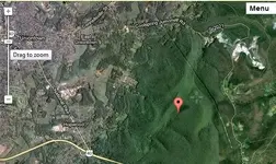
there is a Laurel Caverns cache story Lat. N39 52.793' Long W79 39.932'

(accuracy on Coordinates are Unknown)


Untitledss.jpg


dates from 1804

about 1 8/10th. mi. s./s.e. of Cool Springs
Kirk Outlaw Gang used Dulaney's cave now known as Laurel Caverns as a hideout.
they were all killed and nothing was recovered
 

Last edited:
is there any information on the kirk gank anywhere

If anyone needs help accessing any of these areas. Pm me. I have a 2 seater side by side and would be very happy to help explore. Me and my friends know many of the trails and paths from jaminville coolspring road clear to Morgantown and bruceton mills and we'll and Wharton furnace lemon furnace and skyline drive!
 

If anyone needs help accessing any of these areas. Pm me. I have a 2 seater side by side and would be very happy to help explore. Me and my friends know many of the trails and paths from jaminville coolspring road clear to Morgantown and bruceton mills and we'll and Wharton furnace lemon furnace and skyline drive!
I live right here all my life. I live right above coolspring. There is a cave below my house called the what I always thought was called coal caves. My mom said When she was a little girl which she was born in 1942. They were playing down by the coal caves with her cousin and brother Jack. They saw these men on horses when we now know as cowboys.. they said One day they were playing and seem these men come out of the coal caves.she said they used to go down there to get a drink of water the water was so cold it would make your head hurt. It very well could be cool caves she said she never inside those caves.too afraid of a collapse. But where your Mark is the Stone quarry in coolspring right below the jummonville cross. She told me the old tram road was once the Way the stage coaches used to go up the mountain towards the summit.. My Great great grandfather was named Samuel yauger.. He was a Land Baron. He owned from my home cleat out Evans mannor. He left every one of his children 14 archer of Land. We still own the original house that was built in 1850. Plus the 14 acres. Back then they thought My Great great grandfather stowed his money here. To with it the point some men come to Rob him One day. They held him hostage and one guy took him down to the milk house. Why another man was up stairs searching for his money. Well the one guys name Abraham Dobbs and when he come down stairs a guy name was bunky bosley grabbed a ,10 corn cycle. Cut him head off
It. They said the next days morning herald read robber got his head cut off with 0.10 come cycle. Now I never heard of this Dobb man's name until I read your message today. Now I do not know if this is a related to this story or not. But I do know one thing I may go down and search this cave if possible the cave I am talking about is right off turkey food road..
 

I live right here all my life. I live right above coolspring. There is a cave below my house called the what I always thought was called coal caves. My mom said When she was a little girl which she was born in 1942. They were playing down by the coal caves with her cousin and brother Jack. They saw these men on horses when we now know as cowboys.. they said One day they were playing and seem these men come out of the coal caves.she said they used to go down there to get a drink of water the water was so cold it would make your head hurt. It very well could be cool caves she said she never inside those caves.too afraid of a collapse. But where your Mark is the Stone quarry in coolspring right below the jummonville cross. She told me the old tram road was once the Way the stage coaches used to go up the mountain towards the summit.. My Great great grandfather was named Samuel yauger.. He was a Land Baron. He owned from my home cleat out Evans mannor. He left every one of his children 14 archer of Land. We still own the original house that was built in 1850. Plus the 14 acres. Back then they thought My Great great grandfather stowed his money here. To with it the point some men come to Rob him One day. They held him hostage and one guy took him down to the milk house. Why another man was up stairs searching for his money. Well the one guys name Abraham Dobbs and when he come down stairs a guy name was bunky bosley grabbed a ,10 corn cycle. Cut him head off
It. They said the next days morning herald read robber got his head cut off with 0.10 come cycle. Now I never heard of this Dobb man's name until I read your message today. Now I do not know if this is a related to this story or not. But I do know one thing I may go down and search this cave if possible the cave I am talking about is right off turkey food road.. I said Samuel yauger I meant to say Samuel Evans, hence the name Evans mannor . Sorry I missed spoke.
 

I have been doing alot of research about this lost silver near Uniontown.....I live here and have been at the courthouse, library, and have been doing alot of research online. I can't find anything about this story until the 1970's. I don't think it is accurate. For one, there are really no caves "North" of Uniontown. I propose another location as the possible site for looking for this treasure and I will state some of my reasons.

The site I will be searching is near the Quebec Run Wild Area off of Quebec Road, about 14 miles from Uniontown and about 2 miles from Laurel Caverns. This area is littered with rock formations and caves. In the earliest maps of Fayette County you can find the Quebec Road, and in one map from 1816 this road is called "Turnpike Road". This is one of the earliest roads in the county and goes from Haydentown to Elliotsville, I found reference that it was either the third or fourth road cut. In the 1800's this area was full of mills and tanneries and iron furnaces. There are remnants of these still today, if you look close enough. So, 150 years ago, even though remote, it was bustling with industry and the road would have been well traveled. The second reason for my thinking that buried treasure is in this area is that people after the Civil War thought so. It is not documented on paper, but in the dirt itself. There are dozens of shallow holes hastily dug into the dirt, in the woods, in the Quebec Run Wild Area. I was up there this weekend to finally look for myself, and it is evident that long ago, people were digging holes up there. What were they looking for? Well local legend says that during the Civil War confederate raiders hid gold in a cave "above the run" and sealed the entrance with a blast. Well this is where all of the holes are dug, above the run.

So, right after the Civil War, people heard stories of either gold or silver having been buried by Confederate Soldiers and people started looking for it. I don't know if it has ever been found but it is interesting nonetheless.

Anyone have any thoughts on this? I would be willing to have a companion on these adventures, it is a long walk out there by yourself (about 1 mile).
They could have been looking for Clay for the furnace a wagon of clay was worth about 500 is what my mom told me. Her grandfather would dig a wagon full take it to town and she said he would stay down in the patch for weeks drinking until All the money was gone.
 

Top Member Reactions

Users who are viewing this thread

Back
Top